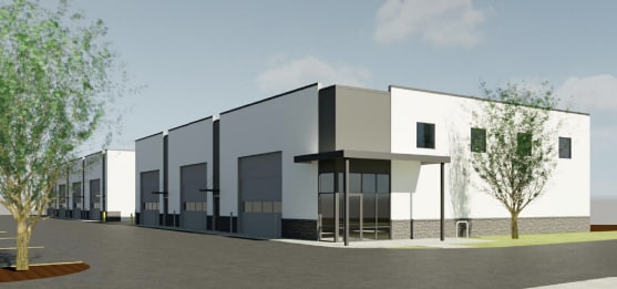
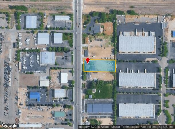
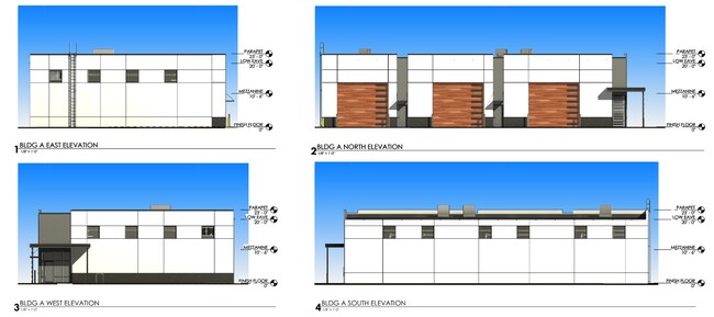
Property Record
300 N Linder Rd, Meridian, ID 83642
NEARBY LISTINGS FOR SALE OR LEASE
Property Detail
300 N Linder Rd
Boise City, ID
Heppers Acre Sub
R3579000020
Ada
Sfr
Idaho
A
1 AC
16001C0231J
Meridian
1,331 SF
Boise City/Nampa
DEMOGRAPHICS near 300 N Linder Rd
1 Mile
3 Mile
5 Mile
2024 Total Population
11,988
85,659
182,858
2029 Population
13,483
96,721
207,198
Pop Growth 2024-2029
+ 12.47%
+ 12.91%
+ 13.31%
Average Age
38
39
39
2024 Total Households
4,636
30,903
64,573
HH Growth 2024-2029
+ 12.94%
+ 13.34%
+ 13.64%
Median Household Inc
$67,028
$82,535
$92,340
Avg Household Size
2.50
2.70
2.80
2024 Avg HH Vehicles
2.00
2.00
2.00
Median Home Value
$356,775
$426,537
$461,266
Median Year Built
1994
2002
2004
Nearby Places
Map Layers
Map Styles
 Street
 Aerial
- Restaurants
- Banks
- Shops
- Fitness
- Groceries
PUBLIC TRANSPORTATION
AIRPORT
Boise Air Trml/Gowen Field
DRIVE
WALK
Distance
Boise Air Trml/Gowen Field
32 min
15.6 mi
Freight Ports
Port of Portland
DRIVE
WALK
Distance
Port of Portland
466 min
422.5 mi
SALE & LEASE HISTORY
LISTING DATE
SALE/LEASE

Jun 11, 2019
For Sale
Jan 09, 2025
For Sale
Jan 07, 2025
For Sale
Nearby Properties
Address
Land Use
TOTAL SIZE
Lot Size
Zoning
Address
Land Use
TOTAL SIZE
Lot Size
Zoning
319,968 SF
19.50 AC
TN-C
Address
Land Use
TOTAL SIZE
Lot Size
Zoning
263,964 SF
16.29 AC
C-G
Address
Land Use
TOTAL SIZE
Lot Size
Zoning
309,845 SF
14.53 AC
R-15
Address
Land Use
TOTAL SIZE
Lot Size
Zoning
413,805 SF
15.64 AC
C-G
Address
Land Use
TOTAL SIZE
Lot Size
Zoning
268,802 SF
8.35 AC
R-40
Address
Land Use
TOTAL SIZE
Lot Size
Zoning
335,459 SF
11.23 AC
R-40
Address
Land Use
TOTAL SIZE
Lot Size
Zoning
12.44 AC
R-15
Address
Land Use
TOTAL SIZE
Lot Size
Zoning
243,949 SF
13.81 AC
R-40
Address
Land Use
TOTAL SIZE
Lot Size
Zoning
239,584 SF
7.83 AC
C-G
Address
Land Use
TOTAL SIZE
Lot Size
Zoning
161,870 SF
8.48 AC
C-G
Address
Land Use
TOTAL SIZE
Lot Size
Zoning
171,454 SF
10.66 AC
C-G
Address
Land Use
TOTAL SIZE
Lot Size
Zoning
200,636 SF
8.95 AC
C-G
Address
Land Use
TOTAL SIZE
Lot Size
Zoning
144,918 SF
4.95 AC
C-G
Address
Land Use
TOTAL SIZE
Lot Size
Zoning
141,360 SF
30.32 AC
I-L
Address
Land Use
TOTAL SIZE
Lot Size
Zoning
10.44 AC
R-15
Address
Land Use
TOTAL SIZE
Lot Size
Zoning
238,300 SF
34.70 AC
I-L
Address
Land Use
TOTAL SIZE
Lot Size
Zoning
127,560 SF
4.29 AC
C-G
Address
Land Use
TOTAL SIZE
Lot Size
Zoning
125,241 SF
6.53 AC
C-G
Address
Land Use
TOTAL SIZE
Lot Size
Zoning
121,306 SF
1.45 AC
C-G
Address
Land Use
TOTAL SIZE
Lot Size
Zoning
211,460 SF
11.75 AC
C-G
Address
Land Use
TOTAL SIZE
Lot Size
Zoning
164,916 SF
8.89 AC
R-15
Address
Land Use
TOTAL SIZE
Lot Size
Zoning
262,845 SF
11.97 AC
R-15
Address
Land Use
TOTAL SIZE
Lot Size
Zoning
128,063 SF
10.78 AC
R-15
Address
Land Use
TOTAL SIZE
Lot Size
Zoning
207,060 SF
9.88 AC
I-L
Address
Land Use
TOTAL SIZE
Lot Size
Zoning
106,606 SF
12.25 AC
C-G
Address
Land Use
TOTAL SIZE
Lot Size
Zoning
184,577 SF
11.39 AC
C-G
Address
Land Use
TOTAL SIZE
Lot Size
Zoning
167,524 SF
7.40 AC
I-L
Address
Land Use
TOTAL SIZE
Lot Size
Zoning
120,500 SF
12.28 AC
I-L
Address
Land Use
TOTAL SIZE
Lot Size
Zoning
89,176 SF
C-G
Address
Land Use
TOTAL SIZE
Lot Size
Zoning
83,636 SF
2.54 AC
C-G
The World's #1 Commercial Real Estate Marketplace
Connect with us
© 2026 CoStar Group
The information above has been obtained from sources believed reliable. While we do not doubt its accuracy we have not verified it and make no guarantee, warranty or representation about it. It is your responsibility to independently confirm its accuracy and completeness. Any projections, opinions, assumptions, or estimates used are for example only and do not represent the current or future performance of the property. The value of this transaction to you depends on tax and other factors which should be evaluated by your tax, financial, and legal advisors. You and your advisors should conduct a careful, independent investigation of the property to determine to your satisfaction the suitability of the property for your needs.