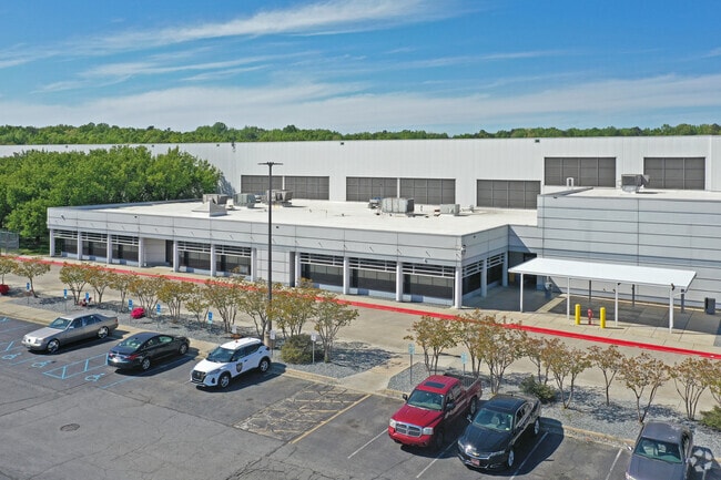
Property Record
300 Penry Rd, Greensboro, NC 27405


NEARBY LISTINGS FOR SALE OR LEASE
Property Detail
300 Penry Rd
Greensboro-High Point, NC
Penrose Estates Sub
0082847
KMART DISTRIBUTION CENTER
Industrialgeneral
Guilford
X
North Carolina
3710788500J
77
2024
93.94 AC
2025
NE Guilford County
012803
Greensboro/Winston-Salem
8,250 SF
DEMOGRAPHICS near 300 Penry Rd
1 Mile
3 Mile
5 Mile
2024 Total Population
2,803
35,817
114,650
2029 Population
2,800
35,994
115,068
Pop Growth 2024-2029
(0.11%)
+ 0.49%
+ 0.36%
Average Age
37
36
36
2024 Total Households
1,036
13,536
42,959
HH Growth 2024-2029
(0.10%)
+ 0.52%
+ 0.48%
Median Household Inc
$38,729
$38,708
$45,085
Avg Household Size
2.60
2.50
2.30
2024 Avg HH Vehicles
2.00
2.00
2.00
Median Home Value
$114,049
$122,472
$157,810
Median Year Built
1970
1977
1978
Nearby Places
Map Layers
Map Styles
 Street
 Aerial
- Restaurants
- Banks
- Shops
- Fitness
- Groceries
PUBLIC TRANSPORTATION
COMMUTER RAIL
Greensboro Station (Piedmont - North Carolina by Train (NC Train))
DRIVE
WALK
Distance
Greensboro Station (Piedmont - North Carolina by Train (NC Train))
10 min
5.5 mi
AIRPORT
Piedmont Triad International
DRIVE
WALK
Distance
Piedmont Triad International
30 min
16.3 mi
Nearby Properties
Address
Land Use
TOTAL SIZE
Lot Size
Zoning
Address
Land Use
TOTAL SIZE
Lot Size
Zoning
313,033 SF
71.38 AC
O
Address
Land Use
TOTAL SIZE
Lot Size
Zoning
364,783 SF
30.12 AC
RM-18
Address
Land Use
TOTAL SIZE
Lot Size
Zoning
418,596 SF
23.53 AC
LI
Address
Land Use
TOTAL SIZE
Lot Size
Zoning
224,444 SF
80.09 AC
PI
Address
Land Use
TOTAL SIZE
Lot Size
Zoning
275,282 SF
43.43 AC
PI
Address
Land Use
TOTAL SIZE
Lot Size
Zoning
505,615 SF
39.50 AC
LI
Address
Land Use
TOTAL SIZE
Lot Size
Zoning
661,843 SF
46.38 AC
PI
Address
Land Use
TOTAL SIZE
Lot Size
Zoning
344,972 SF
65.45 AC
LI
Address
Land Use
TOTAL SIZE
Lot Size
Zoning
293,760 SF
21.94 AC
LI
Address
Land Use
TOTAL SIZE
Lot Size
Zoning
363,920 SF
34.27 AC
LI
Address
Land Use
TOTAL SIZE
Lot Size
Zoning
112,050 SF
9.24 AC
LI
Address
Land Use
TOTAL SIZE
Lot Size
Zoning
419,126 SF
33.68 AC
LI
Address
Land Use
TOTAL SIZE
Lot Size
Zoning
240,170 SF
14.01 AC
LI
Address
Land Use
TOTAL SIZE
Lot Size
Zoning
270,848 SF
18.28 AC
RM-18
Address
Land Use
TOTAL SIZE
Lot Size
Zoning
238,315 SF
19.63 AC
RM-12
Address
Land Use
TOTAL SIZE
Lot Size
Zoning
214,583 SF
20.64 AC
C-H
Address
Land Use
TOTAL SIZE
Lot Size
Zoning
109,948 SF
392.35 AC
HI
Address
Land Use
TOTAL SIZE
Lot Size
Zoning
128,500 SF
14.15 AC
LI
Address
Land Use
TOTAL SIZE
Lot Size
Zoning
1,097,293 SF
73.53 AC
HI
Address
Land Use
TOTAL SIZE
Lot Size
Zoning
204,260 SF
11.83 AC
RM-18
Address
Land Use
TOTAL SIZE
Lot Size
Zoning
152,857 SF
11.58 AC
RM-18
Address
Land Use
TOTAL SIZE
Lot Size
Zoning
305,428 SF
13.72 AC
PUD
Address
Land Use
TOTAL SIZE
Lot Size
Zoning
4,960 SF
29.39 AC
PI
Address
Land Use
TOTAL SIZE
Lot Size
Zoning
153,900 SF
14.23 AC
LI
Address
Land Use
TOTAL SIZE
Lot Size
Zoning
137,573 SF
14.01 AC
C-H
Address
Land Use
TOTAL SIZE
Lot Size
Zoning
83,057 SF
10.24 AC
R-3
Address
Land Use
TOTAL SIZE
Lot Size
Zoning
86,872 SF
8.50 AC
PI
Address
Land Use
TOTAL SIZE
Lot Size
Zoning
6,910 SF
173.96 AC
HI
Address
Land Use
TOTAL SIZE
Lot Size
Zoning
62,524 SF
6.04 AC
RM-18
The World's #1 Commercial Real Estate Marketplace
Connect with us
© 2025 CoStar Group
The information above has been obtained from sources believed reliable. While we do not doubt its accuracy we have not verified it and make no guarantee, warranty or representation about it. It is your responsibility to independently confirm its accuracy and completeness. Any projections, opinions, assumptions, or estimates used are for example only and do not represent the current or future performance of the property. The value of this transaction to you depends on tax and other factors which should be evaluated by your tax, financial, and legal advisors. You and your advisors should conduct a careful, independent investigation of the property to determine to your satisfaction the suitability of the property for your needs.