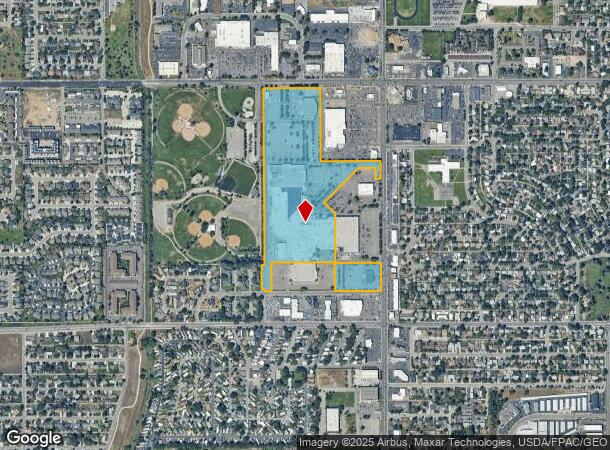
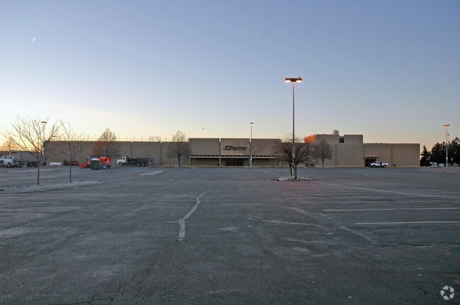
Property Record
300 S 24Th St W, Billings, MT 59102


NEARBY LISTINGS FOR SALE OR LEASE
Property Detail
300 S 24Th St W
03-0926-12-1-04-03-0000
A-1 Cos 1136 2Nd Amd
Commercialnec
S12, T01 S, R25 E, C.O.S. 1136, PARCEL A1, 2ND AMND
X
Yellowstone
30111C1265E
Montana
2024
36.83 AC
2025
Billings
001704
Other Market Areas
537,864 SF
Billings, MT
DEMOGRAPHICS near 300 S 24Th St W
1 Mile
3 Mile
5 Mile
2024 Total Population
11,019
70,594
101,636
2029 Population
11,977
76,588
110,193
Pop Growth 2024-2029
+ 8.69%
+ 8.49%
+ 8.42%
Average Age
42
41
41
2024 Total Households
4,788
30,889
43,665
HH Growth 2024-2029
+ 8.94%
+ 8.67%
+ 8.60%
Median Household Inc
$65,781
$69,143
$68,662
Avg Household Size
2.20
2.20
2.20
2024 Avg HH Vehicles
2.00
2.00
2.00
Median Home Value
$251,028
$286,259
$300,099
Median Year Built
1982
1977
1977
Nearby Places
Map Layers
Map Styles
 Street
 Aerial
- Restaurants
- Banks
- Shops
- Fitness
- Groceries
PUBLIC TRANSPORTATION
AIRPORT
Billings Logan International
DRIVE
WALK
Distance
Billings Logan International
25 min
8.3 mi
Freight Ports
Port of Everett
DRIVE
WALK
Distance
Port of Everett
882 min
839.6 mi
SALE & LEASE HISTORY
LISTING DATE
SALE/LEASE

Sep 25, 2016
For Lease
Mar 04, 2022
For Lease
Dec 12, 2018
For Lease
Nearby Properties
Address
Land Use
TOTAL SIZE
Lot Size
Zoning
Address
Land Use
TOTAL SIZE
Lot Size
Zoning
483,842 SF
55.14 AC
P
Address
Land Use
TOTAL SIZE
Lot Size
Zoning
145.51 AC
Address
Land Use
TOTAL SIZE
Lot Size
Zoning
343,075 SF
0.56 AC
Address
Land Use
TOTAL SIZE
Lot Size
Zoning
164,242 SF
33.08 AC
P
Address
Land Use
TOTAL SIZE
Lot Size
Zoning
167,261 SF
10.55 AC
R-150
Address
Land Use
TOTAL SIZE
Lot Size
Zoning
136,588 SF
21.01 AC
CI
Address
Land Use
TOTAL SIZE
Lot Size
Zoning
32,460 SF
10.88 AC
A-1
Address
Land Use
TOTAL SIZE
Lot Size
Zoning
188,030 SF
13.88 AC
A-1
Address
Land Use
TOTAL SIZE
Lot Size
Zoning
259,684 SF
14.73 AC
Address
Land Use
TOTAL SIZE
Lot Size
Zoning
258,977 SF
18.05 AC
CI
Address
Land Use
TOTAL SIZE
Lot Size
Zoning
173,042 SF
10.27 AC
Address
Land Use
TOTAL SIZE
Lot Size
Zoning
116,250 SF
9.39 AC
Address
Land Use
TOTAL SIZE
Lot Size
Zoning
138,502 SF
18.97 AC
Address
Land Use
TOTAL SIZE
Lot Size
Zoning
156,883 SF
12.86 AC
Address
Land Use
TOTAL SIZE
Lot Size
Zoning
168,124 SF
14.39 AC
HC
Address
Land Use
TOTAL SIZE
Lot Size
Zoning
70,034 SF
7.29 AC
Address
Land Use
TOTAL SIZE
Lot Size
Zoning
173,807 SF
11.56 AC
CI
Address
Land Use
TOTAL SIZE
Lot Size
Zoning
156.04 AC
Address
Land Use
TOTAL SIZE
Lot Size
Zoning
16,656 SF
10.85 AC
Address
Land Use
TOTAL SIZE
Lot Size
Zoning
218,478 SF
18.19 AC
CI
Address
Land Use
TOTAL SIZE
Lot Size
Zoning
109,467 SF
5.97 AC
Address
Land Use
TOTAL SIZE
Lot Size
Zoning
13,216 SF
144.80 AC
A-1
Address
Land Use
TOTAL SIZE
Lot Size
Zoning
177,290 SF
14.59 AC
HC
Address
Land Use
TOTAL SIZE
Lot Size
Zoning
188,907 SF
3.83 AC
CC
Address
Land Use
TOTAL SIZE
Lot Size
Zoning
151,056 SF
49.20 AC
A-1
Address
Land Use
TOTAL SIZE
Lot Size
Zoning
42,186 SF
13.43 AC
Address
Land Use
TOTAL SIZE
Lot Size
Zoning
149,797 SF
12.95 AC
CC
Address
Land Use
TOTAL SIZE
Lot Size
Zoning
26.09 AC
Address
Land Use
TOTAL SIZE
Lot Size
Zoning
1,200 SF
57.17 AC
P
The World's #1 Commercial Real Estate Marketplace
Connect with us
© 2026 CoStar Group
The information above has been obtained from sources believed reliable. While we do not doubt its accuracy we have not verified it and make no guarantee, warranty or representation about it. It is your responsibility to independently confirm its accuracy and completeness. Any projections, opinions, assumptions, or estimates used are for example only and do not represent the current or future performance of the property. The value of this transaction to you depends on tax and other factors which should be evaluated by your tax, financial, and legal advisors. You and your advisors should conduct a careful, independent investigation of the property to determine to your satisfaction the suitability of the property for your needs.