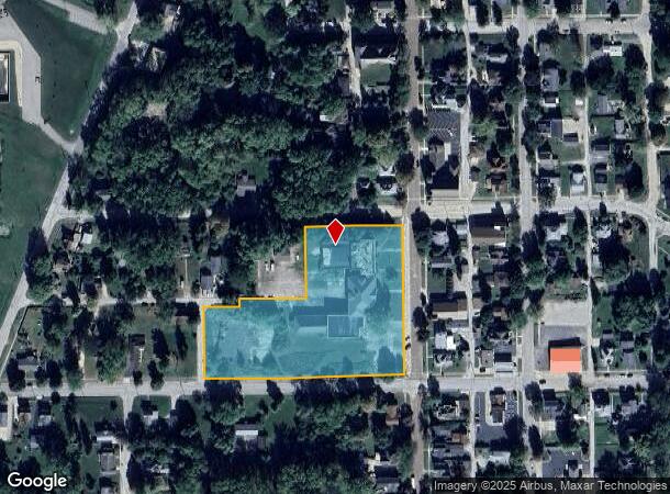
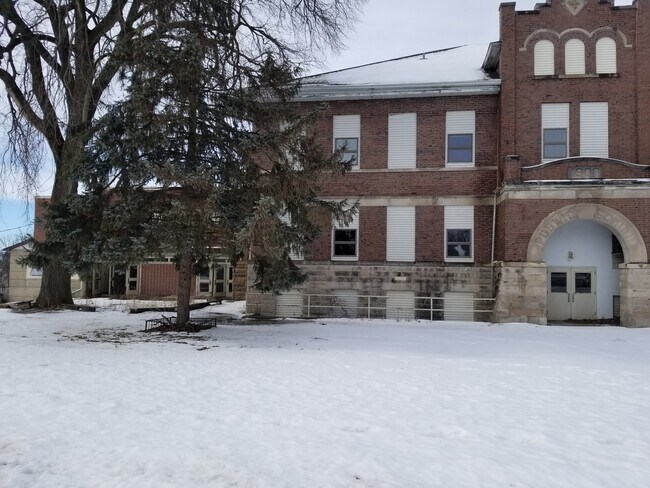
Property Record
300 N Main St, Mount Carroll, IL 61053

NEARBY LISTINGS FOR SALE OR LEASE
-
-
View all Mount Carroll listings for sale on LoopNet.com
Property Detail
300 N Main St
05-08-01-404-009
R & H 3Rd Adt
Publicschool
LOTS 1,2 & 6 BLOCK 5 R & H 3RD ADT PT E 1/2 NW; NE SW SEC 17,TWP 24, RG 5E PARCEL A NORWEST SURVEY
X
Carroll
17015C0205C
Illinois
2024
1-6
2024
3.58 AC
960400
Illinois North Area
55,377 SF
Other Market Areas
DEMOGRAPHICS near 300 N Main St
1 Mile
3 Mile
5 Mile
2024 Total Population
1,617
1,922
2,422
2029 Population
1,609
1,911
2,404
Pop Growth 2024-2029
(0.49%)
(0.57%)
(0.74%)
Average Age
46
46
47
2024 Total Households
717
855
1,082
HH Growth 2024-2029
(0.56%)
(0.70%)
(0.83%)
Median Household Inc
$54,859
$54,940
$55,480
Avg Household Size
2.10
2.10
2.20
2024 Avg HH Vehicles
2.00
2.00
2.00
Median Home Value
$79,829
$83,333
$92,472
Median Year Built
1949
1949
1951
Nearby Places
Map Layers
Map Styles
 Street
 Aerial
- Restaurants
- Banks
- Shops
- Fitness
- Groceries
SALE & LEASE HISTORY
LISTING DATE
SALE/LEASE

Sep 12, 2022
For Sale
Feb 03, 2020
For Sale
Nearby Properties
Address
Land Use
TOTAL SIZE
Lot Size
Zoning
Address
Land Use
TOTAL SIZE
Lot Size
Zoning
3,840 SF
1 AC
Address
Land Use
TOTAL SIZE
Lot Size
Zoning
143.52 AC
Address
Land Use
TOTAL SIZE
Lot Size
Zoning
2,040 SF
1.29 AC
Address
Land Use
TOTAL SIZE
Lot Size
Zoning
2,640 SF
0.60 AC
Address
Land Use
TOTAL SIZE
Lot Size
Zoning
17,930 SF
2.25 AC
Address
Land Use
TOTAL SIZE
Lot Size
Zoning
13,650 SF
1 AC
Address
Land Use
TOTAL SIZE
Lot Size
Zoning
12,000 SF
1 AC
Address
Land Use
TOTAL SIZE
Lot Size
Zoning
3,840 SF
2.73 AC
Address
Land Use
TOTAL SIZE
Lot Size
Zoning
7,200 SF
2.69 AC
Address
Land Use
TOTAL SIZE
Lot Size
Zoning
1,888 SF
2.87 AC
Address
Land Use
TOTAL SIZE
Lot Size
Zoning
264.28 AC
Address
Land Use
TOTAL SIZE
Lot Size
Zoning
3,104 SF
3.30 AC
Address
Land Use
TOTAL SIZE
Lot Size
Zoning
7,120 SF
0.10 AC
Address
Land Use
TOTAL SIZE
Lot Size
Zoning
10,620 SF
4.45 AC
Address
Land Use
TOTAL SIZE
Lot Size
Zoning
2,460 SF
0.66 AC
Address
Land Use
TOTAL SIZE
Lot Size
Zoning
38,400 SF
0.01 AC
Address
Land Use
TOTAL SIZE
Lot Size
Zoning
4,160 SF
1.44 AC
Address
Land Use
TOTAL SIZE
Lot Size
Zoning
198.97 AC
Address
Land Use
TOTAL SIZE
Lot Size
Zoning
Address
Land Use
TOTAL SIZE
Lot Size
Zoning
183.43 AC
Address
Land Use
TOTAL SIZE
Lot Size
Zoning
158.42 AC
Address
Land Use
TOTAL SIZE
Lot Size
Zoning
210.57 AC
Address
Land Use
TOTAL SIZE
Lot Size
Zoning
1,792 SF
0.33 AC
Address
Land Use
TOTAL SIZE
Lot Size
Zoning
2,388 SF
1.59 AC
Address
Land Use
TOTAL SIZE
Lot Size
Zoning
197.65 AC
Address
Land Use
TOTAL SIZE
Lot Size
Zoning
1,644 SF
198.60 AC
Address
Land Use
TOTAL SIZE
Lot Size
Zoning
124.93 AC
Address
Land Use
TOTAL SIZE
Lot Size
Zoning
6,660 SF
1.52 AC
Address
Land Use
TOTAL SIZE
Lot Size
Zoning
171.53 AC
Address
Land Use
TOTAL SIZE
Lot Size
Zoning
8,003 SF
1.29 AC
The World's #1 Commercial Real Estate Marketplace
Connect with us
© 2025 CoStar Group
The information above has been obtained from sources believed reliable. While we do not doubt its accuracy we have not verified it and make no guarantee, warranty or representation about it. It is your responsibility to independently confirm its accuracy and completeness. Any projections, opinions, assumptions, or estimates used are for example only and do not represent the current or future performance of the property. The value of this transaction to you depends on tax and other factors which should be evaluated by your tax, financial, and legal advisors. You and your advisors should conduct a careful, independent investigation of the property to determine to your satisfaction the suitability of the property for your needs.