Property Record
300 S Walnut St, Las Cruces, NM 88001


Property Detail
300 S Walnut St
02-11042
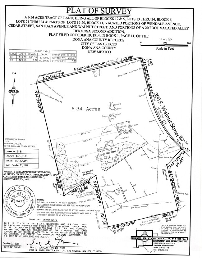
SUBD: HERMOSA SECOND ADDITION SUBDIVISION (BK 1 PG 11) 193 LOT: 1-24 BLOCK: 5 SUBD: HERMOSA SECOND ADDITION SUBDIVISION (BK 1 PG 11) 193 LOT: 13-24 BLOCK: 6 SUBD: HERMOSA SECOND ADDITION SUBDIVISION (BK 1 PG 11) 193 LOT: 19-24 BLOCK: 11 SUBD: HERMOSA
Commercialacreage
DONA ANA
M2
New Mexico
B and X Area of moderate flood hazard, usually the area between the limits of the 100-year and 500-year floods.
1-24
2024
6.34 AC
2025
Las Cruces/Alamogordo
000402
Other Market Areas
6,990 SF
Las Cruces, NM
NEARBY LISTINGS FOR SALE OR LEASE
DEMOGRAPHICS near 300 S Walnut St
1 mile
3 mile
5 mile
2025 Total Population
13,826
81,900
125,281
2030 Population
14,333
85,440
130,786
Pop Growth 2025-2030
+ 3.67%
+ 4.32%
+ 4.39%
Average Age
35
39
39
2025 Total Households
4,809
34,536
50,884
HH Growth 2025-2030
+ 4.33%
+ 4.52%
+ 4.56%
Median Household Inc
$36,579
$47,979
$54,099
Avg Household Size
2.30
2.20
2.30
2025 Avg HH Vehicles
2.00
2.00
2.00
Median Home Value
$153,096
$212,398
$240,498
Median Year Built
1974
1982
1987
Nearby Places
Map Layers
Map Styles
 Street
 Aerial
Layers
 Traffic
 Biking
Places
Listings with unknown addresses are not visible on the map
- Restaurants
- Banks
- Shops
- Fitness
- Groceries
SALE & LEASE HISTORY
LISTING DATE
SALE/LEASE

Sep 24, 2016
For Sale
Nearby Properties
Address
Land Use
TOTAL SIZE
Lot Size
Zoning
Address
Land Use
TOTAL SIZE
Lot Size
Zoning
266,671 SF
23.96 AC
PUD
Address
Land Use
TOTAL SIZE
Lot Size
Zoning
198,290 SF
33.76 AC
R4
Address
Land Use
TOTAL SIZE
Lot Size
Zoning
413,000 SF
R4
Address
Land Use
TOTAL SIZE
Lot Size
Zoning
77,691 SF
Address
Land Use
TOTAL SIZE
Lot Size
Zoning
106,866 SF
10.61 AC
R1
Address
Land Use
TOTAL SIZE
Lot Size
Zoning
240,030 SF
14.74 AC
R4
Address
Land Use
TOTAL SIZE
Lot Size
Zoning
280,731 SF
15.55 AC
PUD
Address
Land Use
TOTAL SIZE
Lot Size
Zoning
29,466 SF
1.33 AC
C2
Address
Land Use
TOTAL SIZE
Lot Size
Zoning
206,137 SF
9.96 AC
R1
Address
Land Use
TOTAL SIZE
Lot Size
Zoning
49 AC
C1
Address
Land Use
TOTAL SIZE
Lot Size
Zoning
66,410 SF
7 AC
PUD
Address
Land Use
TOTAL SIZE
Lot Size
Zoning
6,232 SF
22.74 AC
C2
Address
Land Use
TOTAL SIZE
Lot Size
Zoning
170,972 SF
16.38 AC
R4
Address
Land Use
TOTAL SIZE
Lot Size
Zoning
135,605 SF
6 AC
PUD
Address
Land Use
TOTAL SIZE
Lot Size
Zoning
207,825 SF
25.73 AC
A2
Address
Land Use
TOTAL SIZE
Lot Size
Zoning
98,015 SF
7.85 AC
A1
Address
Land Use
TOTAL SIZE
Lot Size
Zoning
394,043 SF
26.74 AC
C2
Address
Land Use
TOTAL SIZE
Lot Size
Zoning
139,122 SF
6.12 AC
C2
Address
Land Use
TOTAL SIZE
Lot Size
Zoning
52,991 SF
5.95 AC
C2
Address
Land Use
TOTAL SIZE
Lot Size
Zoning
49,295 SF
6.29 AC
R3
Address
Land Use
TOTAL SIZE
Lot Size
Zoning
7,483 SF
16.15 AC
PUD
Address
Land Use
TOTAL SIZE
Lot Size
Zoning
65,535 SF
5.64 AC
R1
Address
Land Use
TOTAL SIZE
Lot Size
Zoning
242,177 SF
21.36 AC
M1
Address
Land Use
TOTAL SIZE
Lot Size
Zoning
14.47 AC
R4
Address
Land Use
TOTAL SIZE
Lot Size
Zoning
27,528 SF
4.65 AC
R1
Address
Land Use
TOTAL SIZE
Lot Size
Zoning
74,724 SF
8 AC
PUD
Address
Land Use
TOTAL SIZE
Lot Size
Zoning
132,179 SF
14.24 AC
M1
Address
Land Use
TOTAL SIZE
Lot Size
Zoning
42,295 SF
7.45 AC
C2
Address
Land Use
TOTAL SIZE
Lot Size
Zoning
76,950 SF
3.95 AC
Address
Land Use
TOTAL SIZE
Lot Size
Zoning
44,506 SF
C2
The World's #1 Commercial Real Estate Marketplace
Connect with us
© 2026 CoStar Group
The information above has been obtained from sources believed reliable. While we do not doubt its accuracy we have not verified it and make no guarantee, warranty or representation about it. It is your responsibility to independently confirm its accuracy and completeness. Any projections, opinions, assumptions, or estimates used are for example only and do not represent the current or future performance of the property. The value of this transaction to you depends on tax and other factors which should be evaluated by your tax, financial, and legal advisors. You and your advisors should conduct a careful, independent investigation of the property to determine to your satisfaction the suitability of the property for your needs.