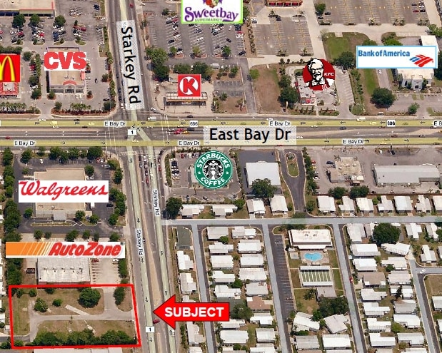
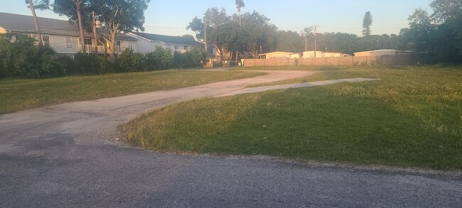
Property Record
300 Starkey Rd, Largo, FL 33771

NEARBY LISTINGS FOR SALE OR LEASE
Property Detail
300 Starkey Rd
Tampa-St. Petersburg-Clearwater, FL
Starkey Carwash
35-29-15-85153-000-0020
STARKEY CARWASH LOT 2
Commercialacreage
Pinellas
X
Florida
12103C0117J
2
2024
0.99 AC
2025
Mid-Pinellas
025417
Tampa/St Petersburg
DEMOGRAPHICS near 300 Starkey Rd
1 Mile
3 Mile
5 Mile
2024 Total Population
14,045
118,884
258,146
2029 Population
13,999
119,200
260,010
Pop Growth 2024-2029
(0.33%)
+ 0.27%
+ 0.72%
Average Age
51
46
46
2024 Total Households
7,071
55,012
116,494
HH Growth 2024-2029
(0.64%)
+ 0.11%
+ 0.70%
Median Household Inc
$52,853
$55,437
$57,518
Avg Household Size
1.90
2.10
2.10
2024 Avg HH Vehicles
1.00
2.00
2.00
Median Home Value
$170,644
$218,176
$254,418
Median Year Built
1976
1975
1976
Nearby Places
Map Layers
Map Styles
 Street
 Aerial
- Restaurants
- Banks
- Shops
- Fitness
- Groceries
PUBLIC TRANSPORTATION
AIRPORT
St Pete-Clearwater International
DRIVE
WALK
Distance
St Pete-Clearwater International
10 min
5.0 mi
Tampa International
DRIVE
WALK
Distance
Tampa International
32 min
18.9 mi
Freight Ports
Port of Tampa Bay
DRIVE
WALK
Distance
Port of Tampa Bay
42 min
25.2 mi
SALE & LEASE HISTORY
LISTING DATE
SALE/LEASE

Sep 24, 2016
For Sale
May 27, 2022
For Sale
May 18, 2022
For Sale
Mar 16, 2023
For Sale
Jul 27, 2023
For Sale
Jan 18, 2023
For Sale
Feb 21, 2024
For Sale
Nearby Properties
Address
Land Use
TOTAL SIZE
Lot Size
Zoning
Address
Land Use
TOTAL SIZE
Lot Size
Zoning
537,958 SF
41.61 AC
C2
Address
Land Use
TOTAL SIZE
Lot Size
Zoning
498,319 SF
15.52 AC
Address
Land Use
TOTAL SIZE
Lot Size
Zoning
529,506 SF
23.06 AC
Address
Land Use
TOTAL SIZE
Lot Size
Zoning
520,871 SF
29 AC
R6
Address
Land Use
TOTAL SIZE
Lot Size
Zoning
367,411 SF
16.12 AC
Address
Land Use
TOTAL SIZE
Lot Size
Zoning
367,081 SF
13.80 AC
Address
Land Use
TOTAL SIZE
Lot Size
Zoning
382,389 SF
13.62 AC
Address
Land Use
TOTAL SIZE
Lot Size
Zoning
333,425 SF
33.66 AC
Address
Land Use
TOTAL SIZE
Lot Size
Zoning
337,954 SF
21 AC
R3
Address
Land Use
TOTAL SIZE
Lot Size
Zoning
305,592 SF
9.65 AC
C2
Address
Land Use
TOTAL SIZE
Lot Size
Zoning
588,657 SF
33 AC
Address
Land Use
TOTAL SIZE
Lot Size
Zoning
364,675 SF
66.40 AC
AE
Address
Land Use
TOTAL SIZE
Lot Size
Zoning
509,129 SF
18.74 AC
Address
Land Use
TOTAL SIZE
Lot Size
Zoning
290,269 SF
8.49 AC
Address
Land Use
TOTAL SIZE
Lot Size
Zoning
384,124 SF
25.78 AC
C3
Address
Land Use
TOTAL SIZE
Lot Size
Zoning
321,140 SF
18.02 AC
Address
Land Use
TOTAL SIZE
Lot Size
Zoning
545,062 SF
8.37 AC
Address
Land Use
TOTAL SIZE
Lot Size
Zoning
266,396 SF
23.18 AC
Address
Land Use
TOTAL SIZE
Lot Size
Zoning
352,158 SF
47.45 AC
Address
Land Use
TOTAL SIZE
Lot Size
Zoning
160,014 SF
7.77 AC
Address
Land Use
TOTAL SIZE
Lot Size
Zoning
296,919 SF
39.10 AC
Address
Land Use
TOTAL SIZE
Lot Size
Zoning
244,655 SF
16.84 AC
AE
Address
Land Use
TOTAL SIZE
Lot Size
Zoning
582,271 SF
17.14 AC
Address
Land Use
TOTAL SIZE
Lot Size
Zoning
225,515 SF
26.82 AC
Address
Land Use
TOTAL SIZE
Lot Size
Zoning
241,547 SF
9.27 AC
Address
Land Use
TOTAL SIZE
Lot Size
Zoning
249,699 SF
15 AC
Address
Land Use
TOTAL SIZE
Lot Size
Zoning
198,688 SF
11.99 AC
Address
Land Use
TOTAL SIZE
Lot Size
Zoning
280,129 SF
Address
Land Use
TOTAL SIZE
Lot Size
Zoning
319,725 SF
9.14 AC
Address
Land Use
TOTAL SIZE
Lot Size
Zoning
84,057 SF
34.26 AC
The World's #1 Commercial Real Estate Marketplace
Connect with us
© 2026 CoStar Group
The information above has been obtained from sources believed reliable. While we do not doubt its accuracy we have not verified it and make no guarantee, warranty or representation about it. It is your responsibility to independently confirm its accuracy and completeness. Any projections, opinions, assumptions, or estimates used are for example only and do not represent the current or future performance of the property. The value of this transaction to you depends on tax and other factors which should be evaluated by your tax, financial, and legal advisors. You and your advisors should conduct a careful, independent investigation of the property to determine to your satisfaction the suitability of the property for your needs.