Property Record
300 Sumpter Rd, Van Buren Township, MI 48111


NEARBY LISTINGS FOR SALE OR LEASE
-
-
View all Van Buren Township listings for sale on LoopNet.com
Property Detail
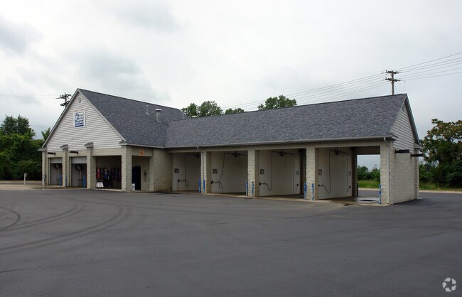
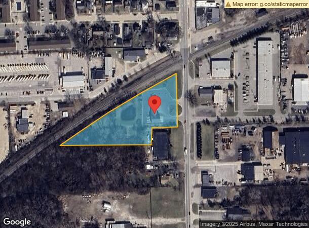
300 Sumpter Rd
Detroit-Warren-Dearborn, MI
Assessors Belleville
31-109-02-0037-002
28B37A1 LOT 37 EXC E 27FT OF PT ADJ TO SUMPTER RD ALSO EXC PT BEG DUE S 1327.60FT AND DUE W 60FT FROM NE COR SEC 28 TH DUE S 8.08FT TH S88DEG 43M 20S W 142.81FT TH S0 DEG 58M 10S W 99.03FT TH S89DEG 37M 40S W 537.63FT TH ON A CUR CONC SELY RAD 5710FT
Autorepair
Wayne
X
Michigan
26163C0353E
37
2025
1.92 AC
2025
Airport District
587000
Detroit
3,916 SF
DEMOGRAPHICS near 300 Sumpter Rd
1 Mile
3 Mile
5 Mile
2024 Total Population
5,218
27,671
58,801
2029 Population
5,019
26,532
57,195
Pop Growth 2024-2029
(3.81%)
(4.12%)
(2.73%)
Average Age
43
41
41
2024 Total Households
2,316
12,187
24,737
HH Growth 2024-2029
(3.80%)
(4.11%)
(2.82%)
Median Household Inc
$55,565
$66,948
$68,794
Avg Household Size
2.20
2.20
2.30
2024 Avg HH Vehicles
2.00
2.00
2.00
Median Home Value
$215,000
$233,694
$211,941
Median Year Built
1979
1978
1978
Nearby Places
Map Layers
Map Styles
 Street
 Aerial
- Restaurants
- Banks
- Shops
- Fitness
- Groceries
PUBLIC TRANSPORTATION
AIRPORT
Detroit Metro Wayne County
DRIVE
WALK
Distance
Detroit Metro Wayne County
18 min
9.6 mi
Windsor International
DRIVE
WALK
Distance
Windsor International
59 min
38.3 mi
Freight Ports
Port of Toledo
DRIVE
WALK
Distance
Port of Toledo
67 min
52.6 mi
Nearby Properties
Address
Land Use
TOTAL SIZE
Lot Size
Zoning
Address
Land Use
TOTAL SIZE
Lot Size
Zoning
461,566 SF
50.13 AC
RM MULT
Address
Land Use
TOTAL SIZE
Lot Size
Zoning
357,286 SF
36.79 AC
RM MULT
Address
Land Use
TOTAL SIZE
Lot Size
Zoning
432.42 AC
M2 GEN
Address
Land Use
TOTAL SIZE
Lot Size
Zoning
206,958 SF
8.33 AC
AP
Address
Land Use
TOTAL SIZE
Lot Size
Zoning
198,549 SF
13.43 AC
RM MULT
Address
Land Use
TOTAL SIZE
Lot Size
Zoning
630,828 SF
62.51 AC
R1B
Address
Land Use
TOTAL SIZE
Lot Size
Zoning
196,044 SF
18.67 AC
RM MULT
Address
Land Use
TOTAL SIZE
Lot Size
Zoning
161,794 SF
17.73 AC
RM MULT
Address
Land Use
TOTAL SIZE
Lot Size
Zoning
132,528 SF
5.91 AC
C2 EXT
Address
Land Use
TOTAL SIZE
Lot Size
Zoning
199,776 SF
39.34 AC
C2 EXT
Address
Land Use
TOTAL SIZE
Lot Size
Zoning
137,893 SF
16.21 AC
C2 EXT
Address
Land Use
TOTAL SIZE
Lot Size
Zoning
191,446 SF
22.76 AC
C2 EXT
Address
Land Use
TOTAL SIZE
Lot Size
Zoning
198,304 SF
23.96 AC
C2 EXT
Address
Land Use
TOTAL SIZE
Lot Size
Zoning
3,184 SF
41.02 AC
Address
Land Use
TOTAL SIZE
Lot Size
Zoning
119,319 SF
10.23 AC
RM MULT
Address
Land Use
TOTAL SIZE
Lot Size
Zoning
62,633 SF
6.39 AC
C LOC
Address
Land Use
TOTAL SIZE
Lot Size
Zoning
69,415 SF
11.32 AC
C2 EXT
Address
Land Use
TOTAL SIZE
Lot Size
Zoning
102,395 SF
11 AC
RM MULT
Address
Land Use
TOTAL SIZE
Lot Size
Zoning
140,677 SF
11.19 AC
RM MULT
Address
Land Use
TOTAL SIZE
Lot Size
Zoning
158,744 SF
10.17 AC
RM MULT
Address
Land Use
TOTAL SIZE
Lot Size
Zoning
500 SF
37.70 AC
Address
Land Use
TOTAL SIZE
Lot Size
Zoning
86,611 SF
15.38 AC
C2 EXT
Address
Land Use
TOTAL SIZE
Lot Size
Zoning
62,729 SF
20.01 AC
C2 EXT
Address
Land Use
TOTAL SIZE
Lot Size
Zoning
72,834 SF
4.97 AC
RM MULT
Address
Land Use
TOTAL SIZE
Lot Size
Zoning
3,640 SF
60.01 AC
RMH MOB
Address
Land Use
TOTAL SIZE
Lot Size
Zoning
83,673 SF
8.22 AC
AP
Address
Land Use
TOTAL SIZE
Lot Size
Zoning
73,239 SF
6.18 AC
RM MULT
Address
Land Use
TOTAL SIZE
Lot Size
Zoning
96,458 SF
7.80 AC
RM MULT
Address
Land Use
TOTAL SIZE
Lot Size
Zoning
95,230 SF
6.32 AC
RM MULT
Address
Land Use
TOTAL SIZE
Lot Size
Zoning
107,235 SF
7.37 AC
The World's #1 Commercial Real Estate Marketplace
Connect with us
© 2026 CoStar Group
The information above has been obtained from sources believed reliable. While we do not doubt its accuracy we have not verified it and make no guarantee, warranty or representation about it. It is your responsibility to independently confirm its accuracy and completeness. Any projections, opinions, assumptions, or estimates used are for example only and do not represent the current or future performance of the property. The value of this transaction to you depends on tax and other factors which should be evaluated by your tax, financial, and legal advisors. You and your advisors should conduct a careful, independent investigation of the property to determine to your satisfaction the suitability of the property for your needs.