Property Record
300 Trails Rd, Eldridge, IA 52748

NEARBY LISTINGS FOR SALE OR LEASE
-
-
View all Eldridge listings for sale on LoopNet.com
Property Detail
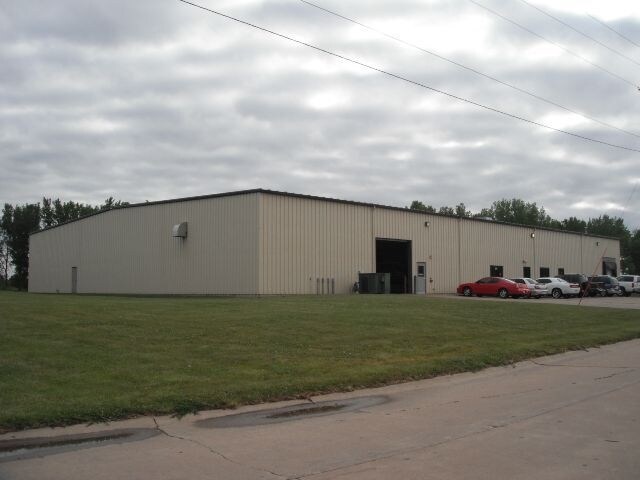
300 Trails Rd
Davenport-Moline-Rock Island, IA-IL
Lancer Ind Park South
932605104
LANCER IND. PARK SOUTH LOT: 004 LANCER IND. PARKSOUTH
Warehouse
Scott
X
Iowa
19163C0355H
4
2025
2.71 AC
2025
Outlying Scott County
010201
Davenport/Moline/Rock Island
320 SF
DEMOGRAPHICS near 300 Trails Rd
1 Mile
3 Mile
5 Mile
2024 Total Population
549
12,475
50,178
2029 Population
542
12,386
49,925
Pop Growth 2024-2029
(1.28%)
(0.71%)
(0.50%)
Average Age
44
39
40
2024 Total Households
253
4,955
20,829
HH Growth 2024-2029
(1.58%)
(0.83%)
(0.58%)
Median Household Inc
$66,923
$69,115
$64,937
Avg Household Size
2.20
2.50
2.30
2024 Avg HH Vehicles
2.00
2.00
2.00
Median Home Value
$270,270
$227,406
$205,004
Median Year Built
1997
1988
1982
Nearby Places
Map Layers
Map Styles
 Street
 Aerial
- Restaurants
- Banks
- Shops
- Fitness
- Groceries
PUBLIC TRANSPORTATION
AIRPORT
Quad Cities International
DRIVE
WALK
Distance
Quad Cities International
35 min
18.3 mi
Freight Ports
Port Milwaukee
DRIVE
WALK
Distance
Port Milwaukee
241 min
213.7 mi
Nearby Properties
Address
Land Use
TOTAL SIZE
Lot Size
Zoning
Address
Land Use
TOTAL SIZE
Lot Size
Zoning
2,615,134 SF
120.68 AC
Address
Land Use
TOTAL SIZE
Lot Size
Zoning
2,545,300 SF
159.73 AC
Address
Land Use
TOTAL SIZE
Lot Size
Zoning
3,360 SF
42.55 AC
Address
Land Use
TOTAL SIZE
Lot Size
Zoning
45,602 SF
149.61 AC
Address
Land Use
TOTAL SIZE
Lot Size
Zoning
688 SF
56.76 AC
Address
Land Use
TOTAL SIZE
Lot Size
Zoning
26,460 SF
42.72 AC
Address
Land Use
TOTAL SIZE
Lot Size
Zoning
12,500 SF
578.76 AC
Address
Land Use
TOTAL SIZE
Lot Size
Zoning
1,440 SF
9.29 AC
Address
Land Use
TOTAL SIZE
Lot Size
Zoning
4,804 SF
202 AC
Address
Land Use
TOTAL SIZE
Lot Size
Zoning
197,946 SF
18.64 AC
Address
Land Use
TOTAL SIZE
Lot Size
Zoning
99,540 SF
10.95 AC
Address
Land Use
TOTAL SIZE
Lot Size
Zoning
422,688 SF
16.44 AC
Address
Land Use
TOTAL SIZE
Lot Size
Zoning
348,893 SF
15.30 AC
Address
Land Use
TOTAL SIZE
Lot Size
Zoning
387,408 SF
13.68 AC
Address
Land Use
TOTAL SIZE
Lot Size
Zoning
98,297 SF
14.73 AC
Address
Land Use
TOTAL SIZE
Lot Size
Zoning
136,292 SF
30.02 AC
Address
Land Use
TOTAL SIZE
Lot Size
Zoning
10,980 SF
42.84 AC
Address
Land Use
TOTAL SIZE
Lot Size
Zoning
175,578 SF
17.19 AC
Address
Land Use
TOTAL SIZE
Lot Size
Zoning
119,808 SF
38.22 AC
Address
Land Use
TOTAL SIZE
Lot Size
Zoning
4,000 SF
8.81 AC
Address
Land Use
TOTAL SIZE
Lot Size
Zoning
113,921 SF
18.78 AC
Address
Land Use
TOTAL SIZE
Lot Size
Zoning
140,242 SF
10.79 AC
Address
Land Use
TOTAL SIZE
Lot Size
Zoning
57,084 SF
8.12 AC
Address
Land Use
TOTAL SIZE
Lot Size
Zoning
28,984 SF
5.64 AC
Address
Land Use
TOTAL SIZE
Lot Size
Zoning
9,862 SF
11.71 AC
Address
Land Use
TOTAL SIZE
Lot Size
Zoning
1,500 SF
31.10 AC
Address
Land Use
TOTAL SIZE
Lot Size
Zoning
4,725 SF
45.96 AC
Address
Land Use
TOTAL SIZE
Lot Size
Zoning
75,000 SF
8.57 AC
Address
Land Use
TOTAL SIZE
Lot Size
Zoning
26,476 SF
24.09 AC
Address
Land Use
TOTAL SIZE
Lot Size
Zoning
35,712 SF
2.09 AC
The World's #1 Commercial Real Estate Marketplace
Connect with us
© 2025 CoStar Group
The information above has been obtained from sources believed reliable. While we do not doubt its accuracy we have not verified it and make no guarantee, warranty or representation about it. It is your responsibility to independently confirm its accuracy and completeness. Any projections, opinions, assumptions, or estimates used are for example only and do not represent the current or future performance of the property. The value of this transaction to you depends on tax and other factors which should be evaluated by your tax, financial, and legal advisors. You and your advisors should conduct a careful, independent investigation of the property to determine to your satisfaction the suitability of the property for your needs.