Property Record
300 W 100 S, Bluffton, IN 46714
NEARBY LISTINGS FOR SALE OR LEASE
Property Detail
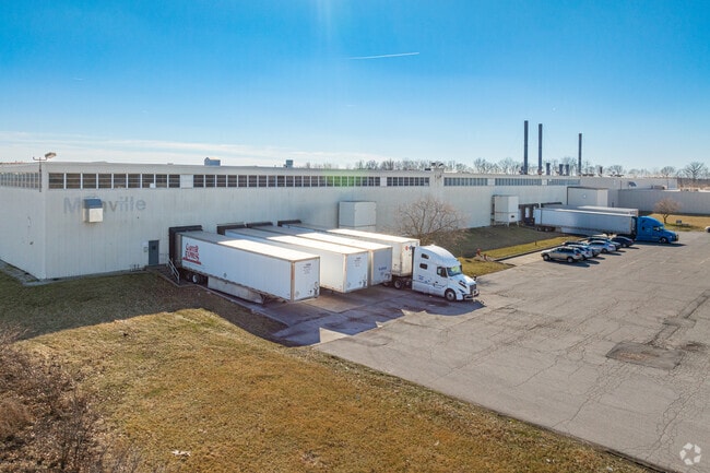
300 W 100 S
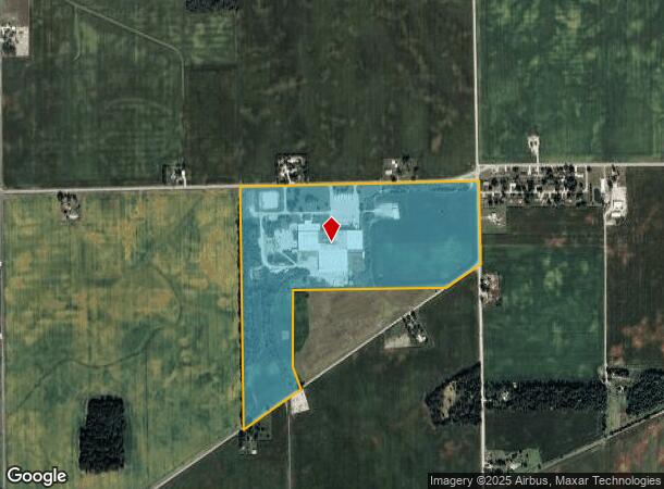
90-09-12-100-001.000-013
12-26-11 85.33 N&W PTS NE N OF MAPLE RD MANVILLE''''S PORTION
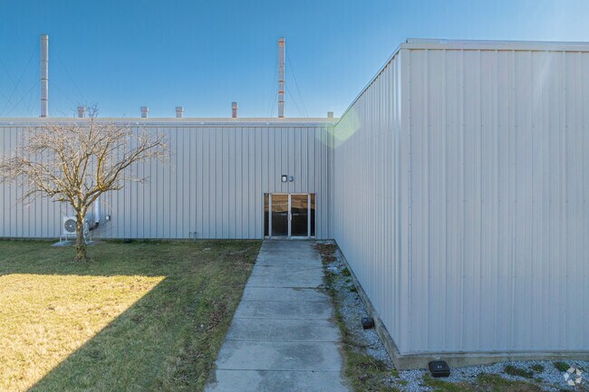
Warehouse
Wells
X
Indiana
18179C0205D
85.33 AC
2024
Wells County
2024
Fort Wayne
040700
Fort Wayne, IN
292,600 SF
DEMOGRAPHICS near 300 W 100 S
1 Mile
3 Mile
5 Mile
2024 Total Population
159
4,855
14,188
2029 Population
158
4,923
14,388
Pop Growth 2024-2029
(0.63%)
+ 1.40%
+ 1.41%
Average Age
41
39
41
2024 Total Households
59
1,960
5,769
HH Growth 2024-2029
0.00%
+ 1.38%
+ 1.40%
Median Household Inc
$80,357
$54,761
$58,771
Avg Household Size
2.70
2.40
2.40
2024 Avg HH Vehicles
3.00
2.00
2.00
Median Home Value
$176,190
$113,394
$147,417
Median Year Built
1954
1958
1970
Nearby Places
Map Layers
Map Styles
 Street
 Aerial
- Restaurants
- Banks
- Shops
- Fitness
- Groceries
PUBLIC TRANSPORTATION
AIRPORT
Fort Wayne International
DRIVE
WALK
Distance
Fort Wayne International
46 min
26.8 mi
Freight Ports
Port of Toledo
DRIVE
WALK
Distance
Port of Toledo
171 min
129.9 mi
SALE & LEASE HISTORY
LISTING DATE
SALE/LEASE

Mar 26, 2018
For Lease
Jan 24, 2020
For Lease
Nearby Properties
Address
Land Use
TOTAL SIZE
Lot Size
Zoning
Address
Land Use
TOTAL SIZE
Lot Size
Zoning
21,875 SF
378.44 AC
Address
Land Use
TOTAL SIZE
Lot Size
Zoning
737,313 SF
24.32 AC
Address
Land Use
TOTAL SIZE
Lot Size
Zoning
400,000 SF
24.64 AC
Address
Land Use
TOTAL SIZE
Lot Size
Zoning
396,510 SF
17.16 AC
Address
Land Use
TOTAL SIZE
Lot Size
Zoning
37.22 AC
Address
Land Use
TOTAL SIZE
Lot Size
Zoning
30.63 AC
Address
Land Use
TOTAL SIZE
Lot Size
Zoning
199,173 SF
12.47 AC
Address
Land Use
TOTAL SIZE
Lot Size
Zoning
277,750 SF
29.45 AC
Address
Land Use
TOTAL SIZE
Lot Size
Zoning
187,516 SF
5.67 AC
Address
Land Use
TOTAL SIZE
Lot Size
Zoning
91,363 SF
35.62 AC
Address
Land Use
TOTAL SIZE
Lot Size
Zoning
36,194 SF
3.77 AC
Address
Land Use
TOTAL SIZE
Lot Size
Zoning
85,588 SF
6.36 AC
Address
Land Use
TOTAL SIZE
Lot Size
Zoning
72,400 SF
12 AC
Address
Land Use
TOTAL SIZE
Lot Size
Zoning
50,080 SF
7.62 AC
Address
Land Use
TOTAL SIZE
Lot Size
Zoning
83,432 SF
4.07 AC
Address
Land Use
TOTAL SIZE
Lot Size
Zoning
169,932 SF
51 AC
Address
Land Use
TOTAL SIZE
Lot Size
Zoning
2,038 SF
7.97 AC
Address
Land Use
TOTAL SIZE
Lot Size
Zoning
6,276 SF
15.40 AC
Address
Land Use
TOTAL SIZE
Lot Size
Zoning
116,422 SF
4 AC
Address
Land Use
TOTAL SIZE
Lot Size
Zoning
55,853 SF
8.60 AC
Address
Land Use
TOTAL SIZE
Lot Size
Zoning
52,473 SF
15.35 AC
Address
Land Use
TOTAL SIZE
Lot Size
Zoning
36,431 SF
16.25 AC
Address
Land Use
TOTAL SIZE
Lot Size
Zoning
39,505 SF
11.51 AC
Address
Land Use
TOTAL SIZE
Lot Size
Zoning
7,908 SF
4.91 AC
Address
Land Use
TOTAL SIZE
Lot Size
Zoning
12,488 SF
0.23 AC
Address
Land Use
TOTAL SIZE
Lot Size
Zoning
13,734 SF
0.19 AC
Address
Land Use
TOTAL SIZE
Lot Size
Zoning
72,182 SF
2.34 AC
Address
Land Use
TOTAL SIZE
Lot Size
Zoning
4,712 SF
8 AC
Address
Land Use
TOTAL SIZE
Lot Size
Zoning
86,141 SF
1.33 AC
The World's #1 Commercial Real Estate Marketplace
Connect with us
© 2026 CoStar Group
The information above has been obtained from sources believed reliable. While we do not doubt its accuracy we have not verified it and make no guarantee, warranty or representation about it. It is your responsibility to independently confirm its accuracy and completeness. Any projections, opinions, assumptions, or estimates used are for example only and do not represent the current or future performance of the property. The value of this transaction to you depends on tax and other factors which should be evaluated by your tax, financial, and legal advisors. You and your advisors should conduct a careful, independent investigation of the property to determine to your satisfaction the suitability of the property for your needs.