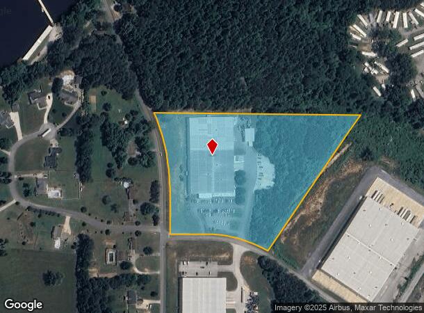
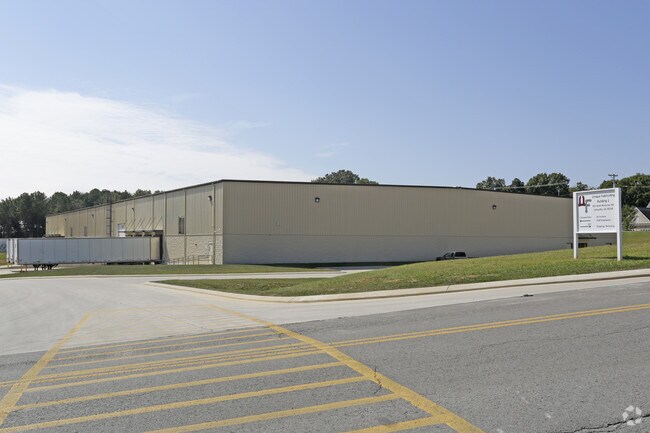
Property Record
300 W Mccarter Rd, La Fayette, GA 30728

NEARBY LISTINGS FOR SALE OR LEASE
-
-
View all La Fayette listings for sale on LoopNet.com
Property Detail
300 W Mccarter Rd
10031-028A
Battlebluff
Industrialgeneral
PTLL 279 8/4
X
Walker
13295C0182D
Georgia
2024
9.69 AC
2024
Walker County
020602
Chattanooga
71,920 SF
Chattanooga, TN-GA
DEMOGRAPHICS near 300 W Mccarter Rd
1 Mile
3 Mile
5 Mile
2024 Total Population
1,312
8,246
16,221
2029 Population
1,375
8,665
16,939
Pop Growth 2024-2029
+ 4.80%
+ 5.08%
+ 4.43%
Average Age
41
40
41
2024 Total Households
520
3,205
6,180
HH Growth 2024-2029
+ 4.81%
+ 5.09%
+ 4.43%
Median Household Inc
$35,068
$37,315
$40,926
Avg Household Size
2.40
2.40
2.50
2024 Avg HH Vehicles
2.00
2.00
2.00
Median Home Value
$160,937
$148,665
$151,058
Median Year Built
1985
1978
1978
Nearby Places
Map Layers
Map Styles
 Street
 Aerial
- Restaurants
- Banks
- Shops
- Fitness
- Groceries
PUBLIC TRANSPORTATION
AIRPORT
Lovell Field
DRIVE
WALK
Distance
Lovell Field
44 min
25.1 mi
Freight Ports
Georgia Ports - Savannah
DRIVE
WALK
Distance
Georgia Ports - Savannah
405 min
350.8 mi
Nearby Properties
Address
Land Use
TOTAL SIZE
Lot Size
Zoning
Address
Land Use
TOTAL SIZE
Lot Size
Zoning
393,974 SF
23.02 AC
I
Address
Land Use
TOTAL SIZE
Lot Size
Zoning
161,820 SF
21.25 AC
R1
Address
Land Use
TOTAL SIZE
Lot Size
Zoning
149,023 SF
18.68 AC
B2
Address
Land Use
TOTAL SIZE
Lot Size
Zoning
75,043 SF
11.48 AC
R2
Address
Land Use
TOTAL SIZE
Lot Size
Zoning
113,243 SF
13.53 AC
I2
Address
Land Use
TOTAL SIZE
Lot Size
Zoning
20,640 SF
1.27 AC
B2
Address
Land Use
TOTAL SIZE
Lot Size
Zoning
75,000 SF
13.22 AC
I2
Address
Land Use
TOTAL SIZE
Lot Size
Zoning
5,406 SF
4.32 AC
B2
Address
Land Use
TOTAL SIZE
Lot Size
Zoning
100,370 SF
4 AC
B2
Address
Land Use
TOTAL SIZE
Lot Size
Zoning
912 SF
323.16 AC
I
Address
Land Use
TOTAL SIZE
Lot Size
Zoning
18 AC
R2
Address
Land Use
TOTAL SIZE
Lot Size
Zoning
40,208 SF
3.96 AC
B2
Address
Land Use
TOTAL SIZE
Lot Size
Zoning
9,113 SF
6.57 AC
R3
Address
Land Use
TOTAL SIZE
Lot Size
Zoning
38,686 SF
6.86 AC
R2
Address
Land Use
TOTAL SIZE
Lot Size
Zoning
414.45 AC
A1
Address
Land Use
TOTAL SIZE
Lot Size
Zoning
1,768 SF
6.52 AC
B2
Address
Land Use
TOTAL SIZE
Lot Size
Zoning
73,601 SF
29 AC
R1
Address
Land Use
TOTAL SIZE
Lot Size
Zoning
12,060 SF
8.45 AC
B2
Address
Land Use
TOTAL SIZE
Lot Size
Zoning
151,784 SF
41.50 AC
I2
Address
Land Use
TOTAL SIZE
Lot Size
Zoning
46,452 SF
1.38 AC
I1
Address
Land Use
TOTAL SIZE
Lot Size
Zoning
41,176 SF
9.22 AC
B2
Address
Land Use
TOTAL SIZE
Lot Size
Zoning
41,620 SF
4.40 AC
B2
Address
Land Use
TOTAL SIZE
Lot Size
Zoning
0.66 AC
B2
Address
Land Use
TOTAL SIZE
Lot Size
Zoning
33,251 SF
8.63 AC
B2
Address
Land Use
TOTAL SIZE
Lot Size
Zoning
10.43 AC
R3
Address
Land Use
TOTAL SIZE
Lot Size
Zoning
22,034 SF
0.36 AC
B1
Address
Land Use
TOTAL SIZE
Lot Size
Zoning
6.60 AC
R2
Address
Land Use
TOTAL SIZE
Lot Size
Zoning
24,002 SF
5.96 AC
B2
Address
Land Use
TOTAL SIZE
Lot Size
Zoning
10,980 SF
34.73 AC
B2
The World's #1 Commercial Real Estate Marketplace
Connect with us
© 2026 CoStar Group
The information above has been obtained from sources believed reliable. While we do not doubt its accuracy we have not verified it and make no guarantee, warranty or representation about it. It is your responsibility to independently confirm its accuracy and completeness. Any projections, opinions, assumptions, or estimates used are for example only and do not represent the current or future performance of the property. The value of this transaction to you depends on tax and other factors which should be evaluated by your tax, financial, and legal advisors. You and your advisors should conduct a careful, independent investigation of the property to determine to your satisfaction the suitability of the property for your needs.