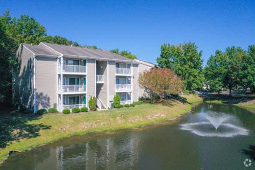
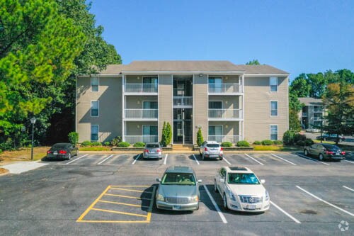
Property Record
300 Wexford Dr, Virginia Beach, VA 23462

NEARBY LISTINGS FOR SALE OR LEASE
-
-
View all Virginia Beach listings for sale on LoopNet.com
Property Detail
300 Wexford Dr
Hampton Roads
Newtown Cross Rds
Virginia Beach-Chesapeake-Norfolk, VA-NC
NEWTOWN CROSS RDS PARCEL B1 11.263 AC
1467-48-9205
Virginia Beach
Apartment
Virginia
2024
11.26 AC
2025
Northwest Virginia Beach
040600
DEMOGRAPHICS near 300 Wexford Dr
1 Mile
3 Mile
5 Mile
2024 Total Population
16,767
105,425
287,328
2029 Population
16,691
104,454
284,444
Pop Growth 2024-2029
(0.45%)
(0.92%)
(1.00%)
Average Age
36
39
39
2024 Total Households
6,595
42,565
112,495
HH Growth 2024-2029
(0.73%)
(1.09%)
(1.21%)
Median Household Inc
$62,517
$69,761
$72,413
Avg Household Size
2.40
2.40
2.50
2024 Avg HH Vehicles
2.00
2.00
2.00
Median Home Value
$218,304
$271,317
$269,429
Median Year Built
1982
1979
1977
Nearby Places
Map Layers
Map Styles
 Street
 Aerial
- Restaurants
- Banks
- Shops
- Fitness
- Groceries
PUBLIC TRANSPORTATION
COMMUTER RAIL
Norfolk (Northeast Regional - Amtrak)
DRIVE
WALK
Distance
Norfolk (Northeast Regional - Amtrak)
11 min
6.7 mi
AIRPORT
Norfolk International
DRIVE
WALK
Distance
Norfolk International
13 min
6.3 mi
Newport News/Williamsburg International
DRIVE
WALK
Distance
Newport News/Williamsburg International
48 min
31.7 mi
Freight Ports
Virginia Port Authority - Portsmouth
DRIVE
WALK
Distance
Virginia Port Authority - Portsmouth
23 min
12.2 mi
Nearby Properties
Address
Land Use
TOTAL SIZE
Lot Size
Zoning
Address
Land Use
TOTAL SIZE
Lot Size
Zoning
2,301.65 AC
Address
Land Use
TOTAL SIZE
Lot Size
Zoning
223 AC
I5
Address
Land Use
TOTAL SIZE
Lot Size
Zoning
Address
Land Use
TOTAL SIZE
Lot Size
Zoning
Address
Land Use
TOTAL SIZE
Lot Size
Zoning
52.36 AC
Address
Land Use
TOTAL SIZE
Lot Size
Zoning
281,816 SF
11.72 AC
Address
Land Use
TOTAL SIZE
Lot Size
Zoning
697,880 SF
200.35 AC
R15
Address
Land Use
TOTAL SIZE
Lot Size
Zoning
30,036 SF
50.39 AC
Address
Land Use
TOTAL SIZE
Lot Size
Zoning
1 SF
42.35 AC
A18
Address
Land Use
TOTAL SIZE
Lot Size
Zoning
23.51 AC
R13
Address
Land Use
TOTAL SIZE
Lot Size
Zoning
132 SF
71.89 AC
Address
Land Use
TOTAL SIZE
Lot Size
Zoning
197,812 SF
8.21 AC
Address
Land Use
TOTAL SIZE
Lot Size
Zoning
15.92 AC
A18
Address
Land Use
TOTAL SIZE
Lot Size
Zoning
95.32 AC
Address
Land Use
TOTAL SIZE
Lot Size
Zoning
15.12 AC
Address
Land Use
TOTAL SIZE
Lot Size
Zoning
434,920 SF
8.35 AC
A36
Address
Land Use
TOTAL SIZE
Lot Size
Zoning
9.62 AC
A36
Address
Land Use
TOTAL SIZE
Lot Size
Zoning
226,775 SF
13.14 AC
B2
Address
Land Use
TOTAL SIZE
Lot Size
Zoning
7.45 AC
B4
Address
Land Use
TOTAL SIZE
Lot Size
Zoning
340,291 SF
18.77 AC
O1
Address
Land Use
TOTAL SIZE
Lot Size
Zoning
18.61 AC
PDH2
Address
Land Use
TOTAL SIZE
Lot Size
Zoning
Address
Land Use
TOTAL SIZE
Lot Size
Zoning
Address
Land Use
TOTAL SIZE
Lot Size
Zoning
23.96 AC
IN2
Address
Land Use
TOTAL SIZE
Lot Size
Zoning
301,631 SF
31.91 AC
I1
Address
Land Use
TOTAL SIZE
Lot Size
Zoning
210,872 SF
2.13 AC
B4
Address
Land Use
TOTAL SIZE
Lot Size
Zoning
246,500 SF
B3A
Address
Land Use
TOTAL SIZE
Lot Size
Zoning
12.85 AC
A24
Address
Land Use
TOTAL SIZE
Lot Size
Zoning
86,497 SF
1.56 AC
B3A
Address
Land Use
TOTAL SIZE
Lot Size
Zoning
319,444 SF
19.02 AC
O1
The World's #1 Commercial Real Estate Marketplace
Connect with us
© 2026 CoStar Group
The information above has been obtained from sources believed reliable. While we do not doubt its accuracy we have not verified it and make no guarantee, warranty or representation about it. It is your responsibility to independently confirm its accuracy and completeness. Any projections, opinions, assumptions, or estimates used are for example only and do not represent the current or future performance of the property. The value of this transaction to you depends on tax and other factors which should be evaluated by your tax, financial, and legal advisors. You and your advisors should conduct a careful, independent investigation of the property to determine to your satisfaction the suitability of the property for your needs.