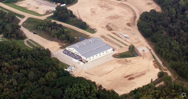
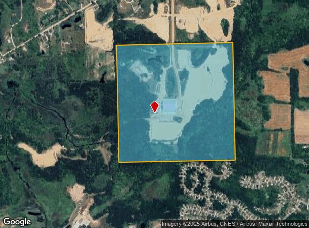
Property Record
3000 E Fisher Rd, Howell, MI 48855
NEARBY LISTINGS FOR SALE OR LEASE
Property Detail
3000 E Fisher Rd
07-19-300-001
SEC. 19 T3N, R5E, SW FRL 1/4 159.26A
Commercialnec
Livingston
AE
Michigan
26093C0193D
159.26 AC
2025
Livingston County
2025
Detroit
724003
Detroit-Warren-Dearborn, MI
75,407 SF
DEMOGRAPHICS near 3000 E Fisher Rd
1 mile
3 mile
5 mile
2024 Total Population
2,908
25,563
43,125
2029 Population
2,958
26,345
44,410
Pop Growth 2024-2029
+ 1.72%
+ 3.06%
+ 2.98%
Average Age
41
41
42
2024 Total Households
1,173
10,307
17,042
HH Growth 2024-2029
+ 1.71%
+ 3.07%
+ 2.95%
Median Household Inc
$83,161
$80,051
$85,500
Avg Household Size
2.50
2.40
2.50
2024 Avg HH Vehicles
2.00
2.00
2.00
Median Home Value
$256,781
$261,686
$276,791
Median Year Built
1997
1992
1993
Nearby Places
Map Layers
Map Styles
 Street
 Aerial
Transit
 Traffic
 Biking
Places
Listings with unknown addresses are not visible on the map
- Restaurants
- Banks
- Shops
- Fitness
- Groceries
PUBLIC TRANSPORTATION
AIRPORT
Bishop International
Drive
Walk
Distance
Bishop International
59 min
35.5 mi
Freight Ports
Port of Toledo
Drive
Walk
Distance
Port of Toledo
117 min
90.5 mi
Nearby Properties
Address
Land Use
TOTAL SIZE
Lot Size
Zoning
Address
Land Use
TOTAL SIZE
Lot Size
Zoning
767,161 SF
127.33 AC
I-1
Address
Land Use
TOTAL SIZE
Lot Size
Zoning
344,387 SF
27.72 AC
I-1
Address
Land Use
TOTAL SIZE
Lot Size
Zoning
89,443 SF
10.45 AC
R-M
Address
Land Use
TOTAL SIZE
Lot Size
Zoning
102,971 SF
11.95 AC
I-1
Address
Land Use
TOTAL SIZE
Lot Size
Zoning
171,564 SF
30.98 AC
O-1
Address
Land Use
TOTAL SIZE
Lot Size
Zoning
145,366 SF
13.60 AC
R-M
Address
Land Use
TOTAL SIZE
Lot Size
Zoning
95,252 SF
11.56 AC
R-M
Address
Land Use
TOTAL SIZE
Lot Size
Zoning
37.65 AC
MFR
Address
Land Use
TOTAL SIZE
Lot Size
Zoning
81,417 SF
13.10 AC
R-M
Address
Land Use
TOTAL SIZE
Lot Size
Zoning
15.74 AC
RM
Address
Land Use
TOTAL SIZE
Lot Size
Zoning
161,366 SF
18.67 AC
HDR
Address
Land Use
TOTAL SIZE
Lot Size
Zoning
80,330 SF
10 AC
MFR
Address
Land Use
TOTAL SIZE
Lot Size
Zoning
87,349 SF
9.68 AC
C,RM,PUD
Address
Land Use
TOTAL SIZE
Lot Size
Zoning
152,606 SF
16 AC
R-M
Address
Land Use
TOTAL SIZE
Lot Size
Zoning
35,546 SF
7.64 AC
R-M
Address
Land Use
TOTAL SIZE
Lot Size
Zoning
57,582 SF
5.32 AC
C,RM,PUD
Address
Land Use
TOTAL SIZE
Lot Size
Zoning
79,801 SF
10.60 AC
B-2
Address
Land Use
TOTAL SIZE
Lot Size
Zoning
43,959 SF
33.51 AC
IFZ
Address
Land Use
TOTAL SIZE
Lot Size
Zoning
154,040 SF
13.70 AC
I
Address
Land Use
TOTAL SIZE
Lot Size
Zoning
121,850 SF
11.85 AC
I-1
Address
Land Use
TOTAL SIZE
Lot Size
Zoning
246 SF
32.70 AC
I-1
Address
Land Use
TOTAL SIZE
Lot Size
Zoning
119,436 SF
12.20 AC
I-1
Address
Land Use
TOTAL SIZE
Lot Size
Zoning
37,892 SF
5.40 AC
R-M
Address
Land Use
TOTAL SIZE
Lot Size
Zoning
57,736 SF
4.84 AC
R-M
Address
Land Use
TOTAL SIZE
Lot Size
Zoning
39,654 SF
1.62 AC
PUD
Address
Land Use
TOTAL SIZE
Lot Size
Zoning
74,030 SF
5.33 AC
Address
Land Use
TOTAL SIZE
Lot Size
Zoning
52,744 SF
4.10 AC
R-M
Address
Land Use
TOTAL SIZE
Lot Size
Zoning
55,100 SF
5 AC
NSC
Address
Land Use
TOTAL SIZE
Lot Size
Zoning
40,005 SF
4.87 AC
RM
The World's #1 Commercial Real Estate Marketplace
Connect with us
© 2026 CoStar Group
The information above has been obtained from sources believed reliable. While we do not doubt its accuracy we have not verified it and make no guarantee, warranty or representation about it. It is your responsibility to independently confirm its accuracy and completeness. Any projections, opinions, assumptions, or estimates used are for example only and do not represent the current or future performance of the property. The value of this transaction to you depends on tax and other factors which should be evaluated by your tax, financial, and legal advisors. You and your advisors should conduct a careful, independent investigation of the property to determine to your satisfaction the suitability of the property for your needs.