Property Record
3000 E Highway 74 Blvd, Monroe, NC 28112
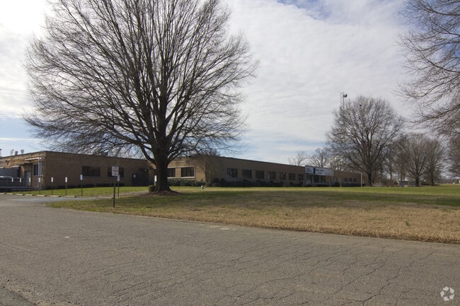

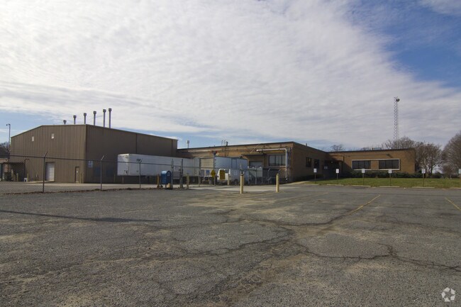
Property Detail
3000 E Highway 74 Blvd
09-087-005
HWY 74 EAST
Manufacturinglight
UNION
G-I MONROE
North Carolina
B and X Area of moderate flood hazard, usually the area between the limits of the 100-year and 500-year floods.
17.21 AC
2025
Union County
2025
Charlotte
020601
Charlotte-Concord-Gastonia, NC-SC
139,544 SF
NEARBY LISTINGS FOR SALE OR LEASE
DEMOGRAPHICS near 3000 E Highway 74 Blvd
1 mile
3 mile
5 mile
2025 Total Population
444
15,136
37,251
2030 Population
500
16,396
40,651
Pop Growth 2025-2030
+ 12.61%
+ 8.32%
+ 9.13%
Average Age
38
37
38
2025 Total Households
139
4,641
12,347
HH Growth 2025-2030
+ 12.95%
+ 8.81%
+ 9.44%
Median Household Inc
$74,999
$58,434
$57,181
Avg Household Size
3.00
2.80
2.80
2025 Avg HH Vehicles
2.00
2.00
2.00
Median Home Value
$382,142
$357,344
$324,793
Median Year Built
1992
1984
1986
Nearby Places
Map Layers
Map Styles
 Street
 Aerial
Transit
 Traffic
 Biking
Places
Listings with unknown addresses are not visible on the map
- Restaurants
- Banks
- Shops
- Fitness
- Groceries
Nearby Properties
Address
Land Use
TOTAL SIZE
Lot Size
Zoning
Address
Land Use
TOTAL SIZE
Lot Size
Zoning
138,123 SF
113.13 AC
B-1 WINGAT
Address
Land Use
TOTAL SIZE
Lot Size
Zoning
82.26 AC
G-I MONROE
Address
Land Use
TOTAL SIZE
Lot Size
Zoning
68,870 SF
33.25 AC
HC WINGATE
Address
Land Use
TOTAL SIZE
Lot Size
Zoning
134,187 SF
32.44 AC
R-10 MONRO
Address
Land Use
TOTAL SIZE
Lot Size
Zoning
68,258 SF
3.39 AC
R-20 WINGA
Address
Land Use
TOTAL SIZE
Lot Size
Zoning
5,376 SF
11.99 AC
R-MF MONRO
Address
Land Use
TOTAL SIZE
Lot Size
Zoning
104,837 SF
29.15 AC
CD MONROE
Address
Land Use
TOTAL SIZE
Lot Size
Zoning
6,672 SF
5.08 AC
OT MONROE
Address
Land Use
TOTAL SIZE
Lot Size
Zoning
2,016 SF
6.20 AC
R-MF MONRO
Address
Land Use
TOTAL SIZE
Lot Size
Zoning
121,790 SF
52.36 AC
G-I MONROE
Address
Land Use
TOTAL SIZE
Lot Size
Zoning
79,493 SF
32.65 AC
RA-20 UNIO
Address
Land Use
TOTAL SIZE
Lot Size
Zoning
2,873 SF
55.59 AC
G-I MONROE
Address
Land Use
TOTAL SIZE
Lot Size
Zoning
32,872 SF
9.35 AC
Address
Land Use
TOTAL SIZE
Lot Size
Zoning
28,468 SF
3.51 AC
B-1 WINGAT
Address
Land Use
TOTAL SIZE
Lot Size
Zoning
32,815 SF
8.28 AC
R-20 MONRO
Address
Land Use
TOTAL SIZE
Lot Size
Zoning
214,256 SF
16.68 AC
G-I MONROE
Address
Land Use
TOTAL SIZE
Lot Size
Zoning
2,712 SF
7.11 AC
R-MH MONRO
Address
Land Use
TOTAL SIZE
Lot Size
Zoning
80,000 SF
10.19 AC
G-I MONROE
Address
Land Use
TOTAL SIZE
Lot Size
Zoning
28.93 AC
Address
Land Use
TOTAL SIZE
Lot Size
Zoning
13,016 SF
15.38 AC
GB MONROE
Address
Land Use
TOTAL SIZE
Lot Size
Zoning
33,946 SF
2.48 AC
CD MONROE
Address
Land Use
TOTAL SIZE
Lot Size
Zoning
40,297 SF
7.95 AC
CD MONROE
Address
Land Use
TOTAL SIZE
Lot Size
Zoning
2,712 SF
6.78 AC
R-MF MONRO
Address
Land Use
TOTAL SIZE
Lot Size
Zoning
34,529 SF
32.09 AC
G-I MONROE
Address
Land Use
TOTAL SIZE
Lot Size
Zoning
7,177 SF
52.47 AC
G-I MONROE
Address
Land Use
TOTAL SIZE
Lot Size
Zoning
194,706 SF
20.47 AC
G-I MONROE
Address
Land Use
TOTAL SIZE
Lot Size
Zoning
15,990 SF
2.13 AC
CD MONROE
Address
Land Use
TOTAL SIZE
Lot Size
Zoning
14,100 SF
8.52 AC
R-10 MONRO
Address
Land Use
TOTAL SIZE
Lot Size
Zoning
202,800 SF
25.51 AC
G-I MONROE
Address
Land Use
TOTAL SIZE
Lot Size
Zoning
19,730 SF
2.78 AC
OT MONROE
The World's #1 Commercial Real Estate Marketplace
Connect with us
© 2026 CoStar Group
The information above has been obtained from sources believed reliable. While we do not doubt its accuracy we have not verified it and make no guarantee, warranty or representation about it. It is your responsibility to independently confirm its accuracy and completeness. Any projections, opinions, assumptions, or estimates used are for example only and do not represent the current or future performance of the property. The value of this transaction to you depends on tax and other factors which should be evaluated by your tax, financial, and legal advisors. You and your advisors should conduct a careful, independent investigation of the property to determine to your satisfaction the suitability of the property for your needs.