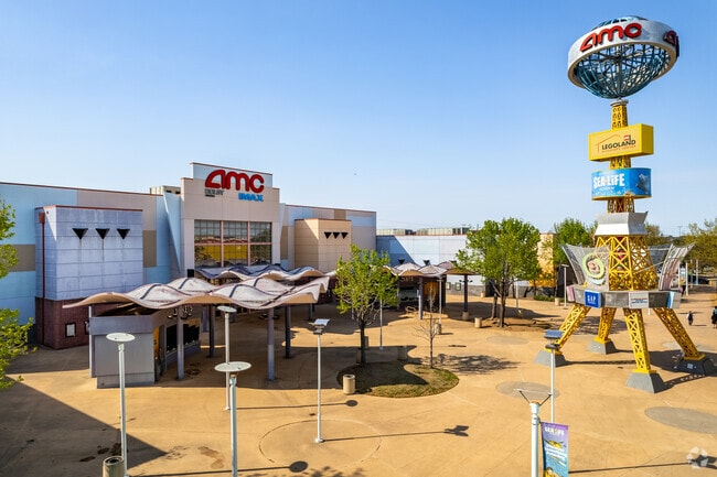
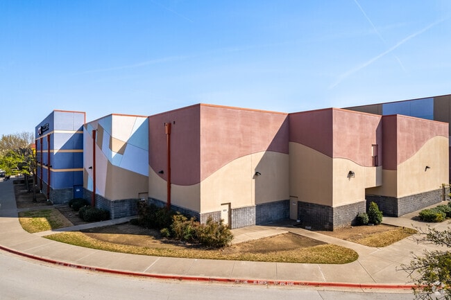
Property Record
3000 Grapevine Mills Pky, Grapevine, TX 76051

Property Detail
3000 Grapevine Mills Pky
Dallas-Fort Worth-Arlington, TX
GRAPEVINE MILLS ADDITION BLOCK 1 LOT 1R3
41307097
Tarrant
Commercialnec
Texas
B and X Area of moderate flood hazard, usually the area between the limits of the 100-year and 500-year floods.
1
2024
124.50 AC
2025
Grapevine/Colleyville
113715
Dallas/Ft Worth
1,325,709 SF
NEARBY LISTINGS FOR SALE OR LEASE
DEMOGRAPHICS near 3000 Grapevine Mills Pky
1 mile
3 mile
5 mile
2025 Total Population
5,280
43,506
179,476
2030 Population
5,878
46,642
193,851
Pop Growth 2025-2030
+ 11.33%
+ 7.21%
+ 8.01%
Average Age
35
38
38
2025 Total Households
2,926
17,573
68,812
HH Growth 2025-2030
+ 8.95%
+ 7.28%
+ 7.83%
Median Household Inc
$92,913
$114,708
$113,837
Avg Household Size
1.80
2.50
2.60
2025 Avg HH Vehicles
2.00
2.00
2.00
Median Home Value
$818,181
$612,564
$497,101
Median Year Built
2009
2001
1995
Nearby Places
Map Layers
Map Styles
 Street
 Aerial
Layers
 Traffic
 Biking
Places
Listings with unknown addresses are not visible on the map
- Restaurants
- Banks
- Shops
- Fitness
- Groceries
PUBLIC TRANSPORTATION
COMMUTER RAIL
Hebron Station (A-train - Denton County Transportation Authority)
Drive
Walk
Distance
Hebron Station (A-train - Denton County Transportation Authority)
14 min
7.2 mi
Old Town Station (A-train - Denton County Transportation Authority)
Drive
Walk
Distance
Old Town Station (A-train - Denton County Transportation Authority)
14 min
7.5 mi
AIRPORT
Dallas-Fort Worth International
Drive
Walk
Distance
Dallas-Fort Worth International
10 min
5.3 mi
Dallas Love Field
Drive
Walk
Distance
Dallas Love Field
29 min
18.8 mi
Freight Ports
Port of Shreveport
Drive
Walk
Distance
Port of Shreveport
235 min
217.1 mi
Nearby Properties
Address
Land Use
TOTAL SIZE
Lot Size
Zoning
Address
Land Use
TOTAL SIZE
Lot Size
Zoning
7,321,782 SF
0.01 AC
Z392
Address
Land Use
TOTAL SIZE
Lot Size
Zoning
3,233,905 SF
51.24 AC
Address
Land Use
TOTAL SIZE
Lot Size
Zoning
2,545,604 SF
123.01 AC
Z402
Address
Land Use
TOTAL SIZE
Lot Size
Zoning
680,063 SF
36.51 AC
Address
Land Use
TOTAL SIZE
Lot Size
Zoning
563,145 SF
Address
Land Use
TOTAL SIZE
Lot Size
Zoning
444,824 SF
19.08 AC
Address
Land Use
TOTAL SIZE
Lot Size
Zoning
527,463 SF
42.25 AC
Address
Land Use
TOTAL SIZE
Lot Size
Zoning
432,986 SF
10.57 AC
Address
Land Use
TOTAL SIZE
Lot Size
Zoning
500,000 SF
99.10 AC
Address
Land Use
TOTAL SIZE
Lot Size
Zoning
768,494 SF
10.42 AC
Address
Land Use
TOTAL SIZE
Lot Size
Zoning
1,581,742 SF
53.48 AC
Z123
Address
Land Use
TOTAL SIZE
Lot Size
Zoning
190,223 SF
0.03 AC
Z392
Address
Land Use
TOTAL SIZE
Lot Size
Zoning
531,979 SF
4.54 AC
Address
Land Use
TOTAL SIZE
Lot Size
Zoning
481,511 SF
34.76 AC
Z172
Address
Land Use
TOTAL SIZE
Lot Size
Zoning
1,065,080 SF
49.57 AC
Z123
Address
Land Use
TOTAL SIZE
Lot Size
Zoning
397,272 SF
12.35 AC
Address
Land Use
TOTAL SIZE
Lot Size
Zoning
457,738 SF
28.49 AC
Address
Land Use
TOTAL SIZE
Lot Size
Zoning
464,476 SF
5.08 AC
Address
Land Use
TOTAL SIZE
Lot Size
Zoning
313,369 SF
55.25 AC
Address
Land Use
TOTAL SIZE
Lot Size
Zoning
950,000 SF
45.32 AC
Z123
Address
Land Use
TOTAL SIZE
Lot Size
Zoning
389,286 SF
21.86 AC
Address
Land Use
TOTAL SIZE
Lot Size
Zoning
394,048 SF
16.36 AC
Address
Land Use
TOTAL SIZE
Lot Size
Zoning
379,940 SF
63.48 AC
Z31
Address
Land Use
TOTAL SIZE
Lot Size
Zoning
284,952 SF
26.18 AC
Address
Land Use
TOTAL SIZE
Lot Size
Zoning
184,186 SF
34.74 AC
Z31
Address
Land Use
TOTAL SIZE
Lot Size
Zoning
397,935 SF
10.65 AC
Address
Land Use
TOTAL SIZE
Lot Size
Zoning
329,666 SF
19.76 AC
Address
Land Use
TOTAL SIZE
Lot Size
Zoning
295,408 SF
10.33 AC
Address
Land Use
TOTAL SIZE
Lot Size
Zoning
947,236 SF
52.19 AC
The World's #1 Commercial Real Estate Marketplace
Connect with us
© 2026 CoStar Group
The information above has been obtained from sources believed reliable. While we do not doubt its accuracy we have not verified it and make no guarantee, warranty or representation about it. It is your responsibility to independently confirm its accuracy and completeness. Any projections, opinions, assumptions, or estimates used are for example only and do not represent the current or future performance of the property. The value of this transaction to you depends on tax and other factors which should be evaluated by your tax, financial, and legal advisors. You and your advisors should conduct a careful, independent investigation of the property to determine to your satisfaction the suitability of the property for your needs.