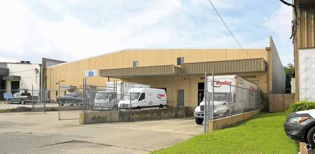
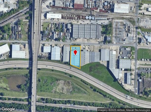
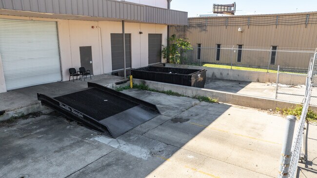
Property Record
3000 Lausat St, Metairie, LA 70001
Current Lease Availabilities
NEARBY LISTINGS FOR SALE OR LEASE
Property Detail
3000 Lausat St
New Orleans-Metairie, LA
Labarre Business Park
0810002577
LOT 4 SEC 3 LABARRE BUSINESS PARK
Realpropertynec
Jefferson
AE
Louisiana
22051C0185F
4
2024
0.85 AC
2024
Metairie
028900
New Orleans/Metairie/Kenner
DEMOGRAPHICS near 3000 Lausat St
1 Mile
3 Mile
5 Mile
2024 Total Population
13,818
129,585
321,496
2029 Population
13,352
124,618
309,404
Pop Growth 2024-2029
(3.37%)
(3.83%)
(3.76%)
Average Age
44
41
41
2024 Total Households
6,360
58,151
141,733
HH Growth 2024-2029
(3.54%)
(4.01%)
(3.89%)
Median Household Inc
$64,620
$59,856
$59,578
Avg Household Size
2.10
2.10
2.20
2024 Avg HH Vehicles
2.00
1.00
1.00
Median Home Value
$286,239
$302,457
$311,595
Median Year Built
1956
1965
1963
Nearby Places
Map Layers
Map Styles
 Street
 Aerial
- Restaurants
- Banks
- Shops
- Fitness
- Groceries
PUBLIC TRANSPORTATION
COMMUTER RAIL
DRIVE
WALK
Distance
12 min
5.8 mi
AIRPORT
Louis Armstrong New Orleans International
DRIVE
WALK
Distance
Louis Armstrong New Orleans International
19 min
10.0 mi
Freight Ports
Port of New Orleans
DRIVE
WALK
Distance
Port of New Orleans
18 min
7.8 mi
Nearby Properties
Address
Land Use
TOTAL SIZE
Lot Size
Zoning
Address
Land Use
TOTAL SIZE
Lot Size
Zoning
22.63 AC
Address
Land Use
TOTAL SIZE
Lot Size
Zoning
50.06 AC
R1A
Address
Land Use
TOTAL SIZE
Lot Size
Zoning
0.14 AC
Address
Land Use
TOTAL SIZE
Lot Size
Zoning
35.06 AC
Address
Land Use
TOTAL SIZE
Lot Size
Zoning
4.31 AC
BC2
Address
Land Use
TOTAL SIZE
Lot Size
Zoning
3.36 AC
EC
Address
Land Use
TOTAL SIZE
Lot Size
Zoning
42.34 AC
Address
Land Use
TOTAL SIZE
Lot Size
Zoning
2.20 AC
EC
Address
Land Use
TOTAL SIZE
Lot Size
Zoning
63.72 AC
OS-N
Address
Land Use
TOTAL SIZE
Lot Size
Zoning
0.08 AC
Address
Land Use
TOTAL SIZE
Lot Size
Zoning
Address
Land Use
TOTAL SIZE
Lot Size
Zoning
66.97 AC
LI
Address
Land Use
TOTAL SIZE
Lot Size
Zoning
Address
Land Use
TOTAL SIZE
Lot Size
Zoning
Address
Land Use
TOTAL SIZE
Lot Size
Zoning
7.98 AC
R1A
Address
Land Use
TOTAL SIZE
Lot Size
Zoning
Address
Land Use
TOTAL SIZE
Lot Size
Zoning
Address
Land Use
TOTAL SIZE
Lot Size
Zoning
66.02 AC
Address
Land Use
TOTAL SIZE
Lot Size
Zoning
Address
Land Use
TOTAL SIZE
Lot Size
Zoning
Address
Land Use
TOTAL SIZE
Lot Size
Zoning
39,963 SF
110.36 AC
OS-N
Address
Land Use
TOTAL SIZE
Lot Size
Zoning
4.90 AC
R2
Address
Land Use
TOTAL SIZE
Lot Size
Zoning
Address
Land Use
TOTAL SIZE
Lot Size
Zoning
0.69 AC
Address
Land Use
TOTAL SIZE
Lot Size
Zoning
0.12 AC
Address
Land Use
TOTAL SIZE
Lot Size
Zoning
92,133 SF
1.89 AC
EC
Address
Land Use
TOTAL SIZE
Lot Size
Zoning
14.56 AC
R1A
Address
Land Use
TOTAL SIZE
Lot Size
Zoning
Address
Land Use
TOTAL SIZE
Lot Size
Zoning
0.11 AC
Address
Land Use
TOTAL SIZE
Lot Size
Zoning
10.76 AC
C2
The World's #1 Commercial Real Estate Marketplace
Connect with us
© 2026 CoStar Group
The information above has been obtained from sources believed reliable. While we do not doubt its accuracy we have not verified it and make no guarantee, warranty or representation about it. It is your responsibility to independently confirm its accuracy and completeness. Any projections, opinions, assumptions, or estimates used are for example only and do not represent the current or future performance of the property. The value of this transaction to you depends on tax and other factors which should be evaluated by your tax, financial, and legal advisors. You and your advisors should conduct a careful, independent investigation of the property to determine to your satisfaction the suitability of the property for your needs.