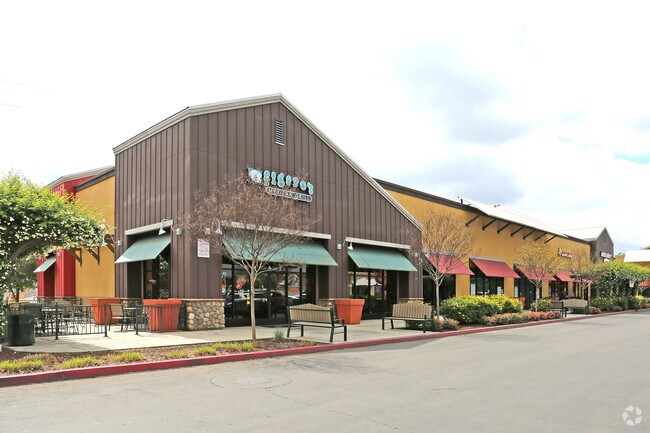
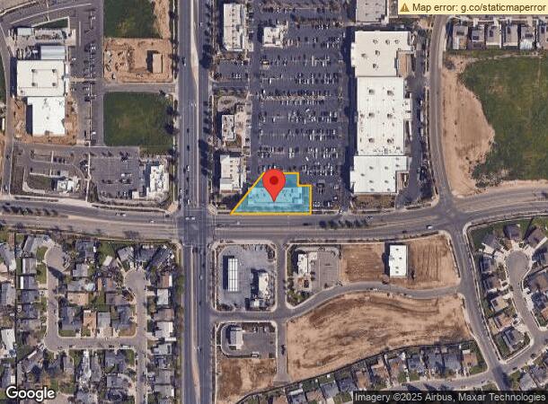
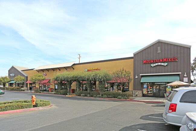
Property Record
3000 N Dinuba Blvd, Visalia, CA 93291

NEARBY LISTINGS FOR SALE OR LEASE
Property Detail
3000 N Dinuba Blvd
079-310-019-000
Parcel Map No 4989
Regionalshoppingcenterormallwithanchorstore
PARCEL 5 PARCEL MAP NO 4989 PM 50-94
X
Tulare
06107C0935E
California
2024
0.69 AC
2025
NW Outlying Tulare County
001009
Visalia/Porterville
10,120 SF
Visalia-Porterville, CA
DEMOGRAPHICS near 3000 N Dinuba Blvd
1 Mile
3 Mile
5 Mile
2024 Total Population
14,101
80,594
158,605
2029 Population
14,623
83,463
164,591
Pop Growth 2024-2029
+ 3.70%
+ 3.56%
+ 3.77%
Average Age
33
35
36
2024 Total Households
3,771
25,286
51,878
HH Growth 2024-2029
+ 3.69%
+ 3.53%
+ 3.75%
Median Household Inc
$62,289
$64,242
$69,513
Avg Household Size
3.60
3.10
3.00
2024 Avg HH Vehicles
2.00
2.00
2.00
Median Home Value
$202,473
$300,804
$295,542
Median Year Built
1989
1985
1986
Nearby Places
Map Layers
Map Styles
 Street
 Aerial
- Restaurants
- Banks
- Shops
- Fitness
- Groceries
PUBLIC TRANSPORTATION
AIRPORT
Fresno Yosemite International
DRIVE
WALK
Distance
Fresno Yosemite International
58 min
43.3 mi
SALE & LEASE HISTORY
LISTING DATE
SALE/LEASE

Mar 24, 2017
For Lease
Aug 17, 2018
For Lease
Nearby Properties
Address
Land Use
TOTAL SIZE
Lot Size
Zoning
Address
Land Use
TOTAL SIZE
Lot Size
Zoning
Address
Land Use
TOTAL SIZE
Lot Size
Zoning
123.41 AC
Address
Land Use
TOTAL SIZE
Lot Size
Zoning
82.35 AC
QP
Address
Land Use
TOTAL SIZE
Lot Size
Zoning
146,890 SF
11.73 AC
CCM
Address
Land Use
TOTAL SIZE
Lot Size
Zoning
139,410 SF
11.35 AC
CC
Address
Land Use
TOTAL SIZE
Lot Size
Zoning
61,587 SF
0.43 AC
PA
Address
Land Use
TOTAL SIZE
Lot Size
Zoning
4.24 AC
Address
Land Use
TOTAL SIZE
Lot Size
Zoning
185,883 SF
9.97 AC
CSO
Address
Land Use
TOTAL SIZE
Lot Size
Zoning
56,384 SF
9.14 AC
Address
Land Use
TOTAL SIZE
Lot Size
Zoning
47,242 SF
3.94 AC
QP-PA
Address
Land Use
TOTAL SIZE
Lot Size
Zoning
54,674 SF
1.26 AC
CDT
Address
Land Use
TOTAL SIZE
Lot Size
Zoning
134,055 SF
3.49 AC
CDT
Address
Land Use
TOTAL SIZE
Lot Size
Zoning
5.85 AC
RM2
Address
Land Use
TOTAL SIZE
Lot Size
Zoning
82,200 SF
6.29 AC
CSO
Address
Land Use
TOTAL SIZE
Lot Size
Zoning
87,160 SF
0.75 AC
PA
Address
Land Use
TOTAL SIZE
Lot Size
Zoning
83,011 SF
4.46 AC
QP
Address
Land Use
TOTAL SIZE
Lot Size
Zoning
133,910 SF
14.35 AC
CSO
Address
Land Use
TOTAL SIZE
Lot Size
Zoning
1.07 AC
CDT
Address
Land Use
TOTAL SIZE
Lot Size
Zoning
47,035 SF
3.29 AC
CCM
Address
Land Use
TOTAL SIZE
Lot Size
Zoning
6.42 AC
CN
Address
Land Use
TOTAL SIZE
Lot Size
Zoning
131,624 SF
7.44 AC
RM3
Address
Land Use
TOTAL SIZE
Lot Size
Zoning
32,741 SF
1.87 AC
Address
Land Use
TOTAL SIZE
Lot Size
Zoning
7,311 SF
2.31 AC
Address
Land Use
TOTAL SIZE
Lot Size
Zoning
27,603 SF
2.86 AC
CCM
Address
Land Use
TOTAL SIZE
Lot Size
Zoning
7,890 SF
2.18 AC
CSO
Address
Land Use
TOTAL SIZE
Lot Size
Zoning
1.65 AC
Address
Land Use
TOTAL SIZE
Lot Size
Zoning
314.02 AC
AE40
The World's #1 Commercial Real Estate Marketplace
Connect with us
© 2025 CoStar Group
The information above has been obtained from sources believed reliable. While we do not doubt its accuracy we have not verified it and make no guarantee, warranty or representation about it. It is your responsibility to independently confirm its accuracy and completeness. Any projections, opinions, assumptions, or estimates used are for example only and do not represent the current or future performance of the property. The value of this transaction to you depends on tax and other factors which should be evaluated by your tax, financial, and legal advisors. You and your advisors should conduct a careful, independent investigation of the property to determine to your satisfaction the suitability of the property for your needs.