Property Record
3000 N Park St, Brenham, TX 77833
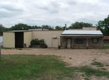

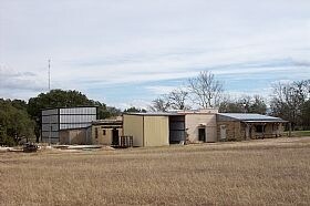
Property Detail
3000 N Park St
0055-000-09700
A0055 HARRINGTON, ARRABELLA, TRACT 97, ACRES 3.696
Taxexempt
Washington
B and X Area of moderate flood hazard, usually the area between the limits of the 100-year and 500-year floods.
Texas
2025
3.70 AC
2025
Central Texas Area
170202
Other Market Areas
4,309 SF
Brenham, TX
NEARBY LISTINGS FOR SALE OR LEASE
DEMOGRAPHICS near 3000 N Park St
1 mile
3 mile
5 mile
2024 Total Population
1,521
14,330
23,967
2029 Population
1,597
15,099
25,195
Pop Growth 2024-2029
+ 5.00%
+ 5.37%
+ 5.12%
Average Age
41
40
40
2024 Total Households
563
5,422
8,950
HH Growth 2024-2029
+ 5.86%
+ 6.12%
+ 5.81%
Median Household Inc
$69,121
$63,138
$65,978
Avg Household Size
2.60
2.40
2.40
2024 Avg HH Vehicles
2.00
2.00
2.00
Median Home Value
$311,538
$270,824
$274,807
Median Year Built
1999
1985
1988
Nearby Places
Map Layers
Map Styles
 Street
 Aerial
Transit
 Traffic
 Biking
Places
Listings with unknown addresses are not visible on the map
- Restaurants
- Banks
- Shops
- Fitness
- Groceries
PUBLIC TRANSPORTATION
AIRPORT
Easterwood Field
Drive
Walk
Distance
Easterwood Field
58 min
39.4 mi
Freight Ports
Port of Houston
Drive
Walk
Distance
Port of Houston
105 min
85.7 mi
Nearby Properties
Address
Land Use
TOTAL SIZE
Lot Size
Zoning
Address
Land Use
TOTAL SIZE
Lot Size
Zoning
172,665 SF
12.76 AC
Address
Land Use
TOTAL SIZE
Lot Size
Zoning
91,028 SF
3.94 AC
Address
Land Use
TOTAL SIZE
Lot Size
Zoning
118,557 SF
11.53 AC
Address
Land Use
TOTAL SIZE
Lot Size
Zoning
101,192 SF
3.77 AC
Address
Land Use
TOTAL SIZE
Lot Size
Zoning
92,565 SF
17.45 AC
Address
Land Use
TOTAL SIZE
Lot Size
Zoning
106,211 SF
48.30 AC
Address
Land Use
TOTAL SIZE
Lot Size
Zoning
42,642 SF
6.30 AC
Address
Land Use
TOTAL SIZE
Lot Size
Zoning
68,357 SF
6.70 AC
Address
Land Use
TOTAL SIZE
Lot Size
Zoning
140.66 AC
Address
Land Use
TOTAL SIZE
Lot Size
Zoning
35,655 SF
52.35 AC
Address
Land Use
TOTAL SIZE
Lot Size
Zoning
171,429 SF
7.08 AC
Address
Land Use
TOTAL SIZE
Lot Size
Zoning
97,848 SF
7.66 AC
Address
Land Use
TOTAL SIZE
Lot Size
Zoning
68,117 SF
7.83 AC
Address
Land Use
TOTAL SIZE
Lot Size
Zoning
38,711 SF
6.70 AC
Address
Land Use
TOTAL SIZE
Lot Size
Zoning
45,049 SF
2.33 AC
Address
Land Use
TOTAL SIZE
Lot Size
Zoning
38,711 SF
3.91 AC
Address
Land Use
TOTAL SIZE
Lot Size
Zoning
30,396 SF
6.83 AC
Address
Land Use
TOTAL SIZE
Lot Size
Zoning
10,023 SF
3.70 AC
Address
Land Use
TOTAL SIZE
Lot Size
Zoning
45.73 AC
Address
Land Use
TOTAL SIZE
Lot Size
Zoning
71,250 SF
3.99 AC
Address
Land Use
TOTAL SIZE
Lot Size
Zoning
38,944 SF
4.51 AC
Address
Land Use
TOTAL SIZE
Lot Size
Zoning
1,577 SF
259.87 AC
Address
Land Use
TOTAL SIZE
Lot Size
Zoning
44,337 SF
8.97 AC
Address
Land Use
TOTAL SIZE
Lot Size
Zoning
18,850 SF
4.48 AC
Address
Land Use
TOTAL SIZE
Lot Size
Zoning
7,094 SF
38.91 AC
Address
Land Use
TOTAL SIZE
Lot Size
Zoning
68,086 SF
2.48 AC
Address
Land Use
TOTAL SIZE
Lot Size
Zoning
61,470 SF
9.83 AC
Address
Land Use
TOTAL SIZE
Lot Size
Zoning
1,266 SF
196.92 AC
Address
Land Use
TOTAL SIZE
Lot Size
Zoning
60,951 SF
1.91 AC
Address
Land Use
TOTAL SIZE
Lot Size
Zoning
42,569 SF
2.04 AC
The World's #1 Commercial Real Estate Marketplace
Connect with us
© 2026 CoStar Group
The information above has been obtained from sources believed reliable. While we do not doubt its accuracy we have not verified it and make no guarantee, warranty or representation about it. It is your responsibility to independently confirm its accuracy and completeness. Any projections, opinions, assumptions, or estimates used are for example only and do not represent the current or future performance of the property. The value of this transaction to you depends on tax and other factors which should be evaluated by your tax, financial, and legal advisors. You and your advisors should conduct a careful, independent investigation of the property to determine to your satisfaction the suitability of the property for your needs.