Property Record
3000 Smith St, Houston, TX 77006
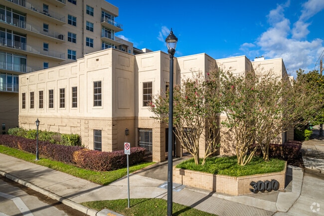

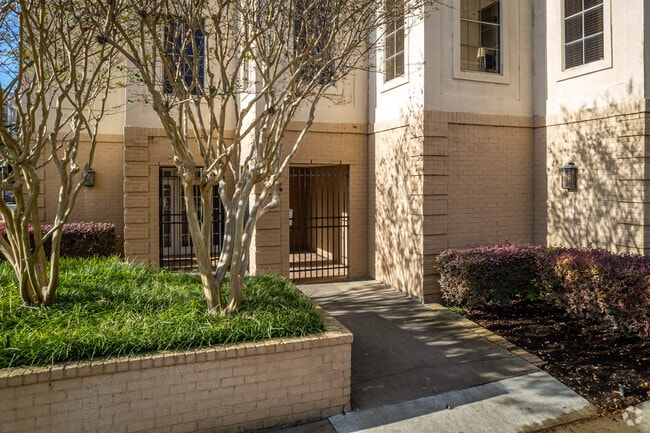
Property Detail
3000 Smith St
Houston-Pasadena-The Woodlands, TX
LTS 3 4 & 9 BLK 21 FAIRGROUNDS
0132390000003
HARRIS
Officebuilding
Texas
B and X Area of moderate flood hazard, usually the area between the limits of the 100-year and 500-year floods.
3
2024
0.34 AC
2025
Midtown
410601
Houston
23,417 SF
NEARBY LISTINGS FOR SALE OR LEASE
DEMOGRAPHICS near 3000 Smith St
1 mile
3 mile
5 mile
2025 Total Population
37,869
240,392
530,238
2030 Population
41,161
260,665
574,480
Pop Growth 2025-2030
+ 8.69%
+ 8.43%
+ 8.34%
Average Age
37
38
38
2025 Total Households
22,141
115,320
243,913
HH Growth 2025-2030
+ 8.94%
+ 9.38%
+ 8.93%
Median Household Inc
$91,830
$99,092
$88,971
Avg Household Size
1.60
1.80
2.00
2025 Avg HH Vehicles
1.00
1.00
2.00
Median Home Value
$462,558
$524,575
$488,825
Median Year Built
2004
2002
1996
Nearby Places
Map Layers
Map Styles
 Street
 Aerial
Layers
 Traffic
 Biking
Places
Listings with unknown addresses are not visible on the map
- Restaurants
- Banks
- Shops
- Fitness
- Groceries
PUBLIC TRANSPORTATION
TRANSIT/SUBWAY
McGowen (Redline - Harris County Metropolitan Transit Authority METRO Rail (METRORail))
Drive
Walk
Distance
McGowen (Redline - Harris County Metropolitan Transit Authority METRO Rail (METRORail))
1 min
9 min
0.5 mi
Ensemble/HCC (Redline - Harris County Metropolitan Transit Authority METRO Rail (METRORail))
Drive
Walk
Distance
Ensemble/HCC (Redline - Harris County Metropolitan Transit Authority METRO Rail (METRORail))
2 min
11 min
0.6 mi
Downtown Transit Center (Redline - Harris County Metropolitan Transit Authority METRO Rail (METRORail))
Drive
Walk
Distance
Downtown Transit Center (Redline - Harris County Metropolitan Transit Authority METRO Rail (METRORail))
3 min
17 min
0.9 mi
AIRPORT
William P Hobby
Drive
Walk
Distance
William P Hobby
25 min
12.1 mi
George Bush Intcntl/Houston
Drive
Walk
Distance
George Bush Intcntl/Houston
28 min
21.7 mi
SALE & LEASE HISTORY
LISTING DATE
SALE/LEASE

Sep 24, 2016
For Sale
Sep 22, 2021
For Sale
Jun 02, 2025
For Sale
Nearby Properties
Address
Land Use
TOTAL SIZE
Lot Size
Zoning
Address
Land Use
TOTAL SIZE
Lot Size
Zoning
1,383,720 SF
1.47 AC
Address
Land Use
TOTAL SIZE
Lot Size
Zoning
1,101,686 SF
1.45 AC
Address
Land Use
TOTAL SIZE
Lot Size
Zoning
973,861 SF
1.18 AC
Address
Land Use
TOTAL SIZE
Lot Size
Zoning
899,279 SF
1.18 AC
Address
Land Use
TOTAL SIZE
Lot Size
Zoning
797,208 SF
1.46 AC
Address
Land Use
TOTAL SIZE
Lot Size
Zoning
519,409 SF
1.52 AC
Address
Land Use
TOTAL SIZE
Lot Size
Zoning
1,916,394 SF
1.46 AC
Address
Land Use
TOTAL SIZE
Lot Size
Zoning
1,871,418 SF
1.44 AC
Address
Land Use
TOTAL SIZE
Lot Size
Zoning
1,252,274 SF
2.02 AC
Address
Land Use
TOTAL SIZE
Lot Size
Zoning
1,091,726 SF
2.60 AC
Address
Land Use
TOTAL SIZE
Lot Size
Zoning
1,232,364 SF
1.49 AC
Address
Land Use
TOTAL SIZE
Lot Size
Zoning
1,436,400 SF
1.44 AC
Address
Land Use
TOTAL SIZE
Lot Size
Zoning
1,321,033 SF
1.46 AC
Address
Land Use
TOTAL SIZE
Lot Size
Zoning
4,169,721 SF
31.23 AC
Address
Land Use
TOTAL SIZE
Lot Size
Zoning
2,005,097 SF
1.44 AC
Address
Land Use
TOTAL SIZE
Lot Size
Zoning
1,374,271 SF
1.44 AC
Address
Land Use
TOTAL SIZE
Lot Size
Zoning
1,150,681 SF
1.17 AC
Address
Land Use
TOTAL SIZE
Lot Size
Zoning
515,025 SF
1.50 AC
Address
Land Use
TOTAL SIZE
Lot Size
Zoning
1,657,484 SF
1.44 AC
Address
Land Use
TOTAL SIZE
Lot Size
Zoning
1,282,908 SF
2.74 AC
Address
Land Use
TOTAL SIZE
Lot Size
Zoning
1,311,133 SF
1.44 AC
Address
Land Use
TOTAL SIZE
Lot Size
Zoning
555,351 SF
1.40 AC
Address
Land Use
TOTAL SIZE
Lot Size
Zoning
1,181,384 SF
1.47 AC
Address
Land Use
TOTAL SIZE
Lot Size
Zoning
1,044,305 SF
3.16 AC
Address
Land Use
TOTAL SIZE
Lot Size
Zoning
1,162,204 SF
1.44 AC
Address
Land Use
TOTAL SIZE
Lot Size
Zoning
934,258 SF
1.45 AC
Address
Land Use
TOTAL SIZE
Lot Size
Zoning
1,103,424 SF
1.44 AC
Address
Land Use
TOTAL SIZE
Lot Size
Zoning
1,365,801 SF
1.44 AC
Address
Land Use
TOTAL SIZE
Lot Size
Zoning
565,276 SF
1.35 AC
Address
Land Use
TOTAL SIZE
Lot Size
Zoning
644,352 SF
8.05 AC
The World's #1 Commercial Real Estate Marketplace
Connect with us
© 2026 CoStar Group
The information above has been obtained from sources believed reliable. While we do not doubt its accuracy we have not verified it and make no guarantee, warranty or representation about it. It is your responsibility to independently confirm its accuracy and completeness. Any projections, opinions, assumptions, or estimates used are for example only and do not represent the current or future performance of the property. The value of this transaction to you depends on tax and other factors which should be evaluated by your tax, financial, and legal advisors. You and your advisors should conduct a careful, independent investigation of the property to determine to your satisfaction the suitability of the property for your needs.