Property Record
3020 33Rd St Ne, Minot, ND 58703
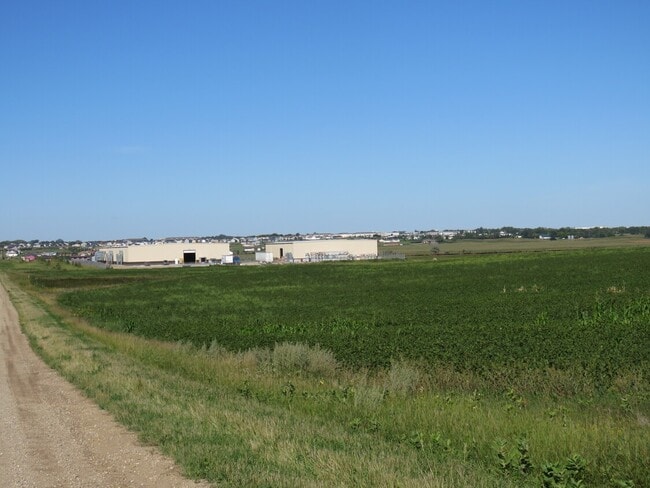
This Property Is For Sale
NEARBY LISTINGS FOR SALE OR LEASE
Property Detail
3020 33Rd St Ne
Other Market Areas
East Industrial Addition
Minot, ND
SUB: MI05E40 NORTHEAST INDUSTRIAL ADDITION LOT 3 BLOCK 3
MI05E400300030
Ward
Agriculturalland
North Dakota
2024
3
2024
10.46 AC
010302
Northeast Minot
DEMOGRAPHICS near 3020 33Rd St Ne
1 Mile
3 Mile
5 Mile
2024 Total Population
48
9,524
42,303
2029 Population
48
9,458
41,803
Pop Growth 2024-2029
0.00%
(0.69%)
(1.18%)
Average Age
34
35
37
2024 Total Households
21
4,081
17,855
HH Growth 2024-2029
(4.76%)
(0.86%)
(1.26%)
Median Household Inc
$71,249
$68,117
$70,250
Avg Household Size
2.20
2.20
2.30
2024 Avg HH Vehicles
2.00
2.00
2.00
Median Home Value
$316,667
$213,162
$233,442
Median Year Built
2008
1977
1978
Nearby Places
- Restaurants
- Banks
- Shops
- Fitness
- Groceries
PUBLIC TRANSPORTATION
COMMUTER RAIL
Minot Amtrak Station (Empire Builder - Amtrak)
DRIVE
WALK
Distance
Minot Amtrak Station (Empire Builder - Amtrak)
13 min
5.7 mi
AIRPORT
Minot International
DRIVE
WALK
Distance
Minot International
15 min
5.6 mi
Freight Ports
Port Milwaukee
DRIVE
WALK
Distance
Port Milwaukee
955 min
876.6 mi
Nearby Properties
Address
Land Use
TOTAL SIZE
Lot Size
Zoning
Address
Land Use
TOTAL SIZE
Lot Size
Zoning
4,000 SF
59.25 AC
Address
Land Use
TOTAL SIZE
Lot Size
Zoning
46,496 SF
2.41 AC
Address
Land Use
TOTAL SIZE
Lot Size
Zoning
47,150 SF
6.43 AC
Address
Land Use
TOTAL SIZE
Lot Size
Zoning
30,000 SF
8.53 AC
Address
Land Use
TOTAL SIZE
Lot Size
Zoning
31,924 SF
2.82 AC
Address
Land Use
TOTAL SIZE
Lot Size
Zoning
28,600 SF
1.41 AC
Address
Land Use
TOTAL SIZE
Lot Size
Zoning
6,120 SF
0.53 AC
Address
Land Use
TOTAL SIZE
Lot Size
Zoning
6,930 SF
0.51 AC
Address
Land Use
TOTAL SIZE
Lot Size
Zoning
12,000 SF
2 AC
Address
Land Use
TOTAL SIZE
Lot Size
Zoning
121 AC
Address
Land Use
TOTAL SIZE
Lot Size
Zoning
9,900 SF
1.39 AC
Address
Land Use
TOTAL SIZE
Lot Size
Zoning
4,244 SF
0.60 AC
Address
Land Use
TOTAL SIZE
Lot Size
Zoning
20,818 SF
1.80 AC
Address
Land Use
TOTAL SIZE
Lot Size
Zoning
40.12 AC
Address
Land Use
TOTAL SIZE
Lot Size
Zoning
12,400 SF
0.67 AC
Address
Land Use
TOTAL SIZE
Lot Size
Zoning
6,000 SF
3.17 AC
Address
Land Use
TOTAL SIZE
Lot Size
Zoning
51.50 AC
Address
Land Use
TOTAL SIZE
Lot Size
Zoning
6,500 SF
2.11 AC
Address
Land Use
TOTAL SIZE
Lot Size
Zoning
2,468 SF
0.54 AC
Address
Land Use
TOTAL SIZE
Lot Size
Zoning
6,316 SF
0.82 AC
Address
Land Use
TOTAL SIZE
Lot Size
Zoning
19,947 SF
0.81 AC
Address
Land Use
TOTAL SIZE
Lot Size
Zoning
50.21 AC
Address
Land Use
TOTAL SIZE
Lot Size
Zoning
8.28 AC
Address
Land Use
TOTAL SIZE
Lot Size
Zoning
5,888 SF
2.18 AC
Address
Land Use
TOTAL SIZE
Lot Size
Zoning
3.72 AC
Address
Land Use
TOTAL SIZE
Lot Size
Zoning
928 SF
1.53 AC
Address
Land Use
TOTAL SIZE
Lot Size
Zoning
Address
Land Use
TOTAL SIZE
Lot Size
Zoning
2.37 AC
Address
Land Use
TOTAL SIZE
Lot Size
Zoning
6,232 SF
3.58 AC
The World's #1 Commercial Real Estate Marketplace
Connect with us
© 2025 CoStar Group
The information above has been obtained from sources believed reliable. While we do not doubt its accuracy we have not verified it and make no guarantee, warranty or representation about it. It is your responsibility to independently confirm its accuracy and completeness. Any projections, opinions, assumptions, or estimates used are for example only and do not represent the current or future performance of the property. The value of this transaction to you depends on tax and other factors which should be evaluated by your tax, financial, and legal advisors. You and your advisors should conduct a careful, independent investigation of the property to determine to your satisfaction the suitability of the property for your needs.