Property Record
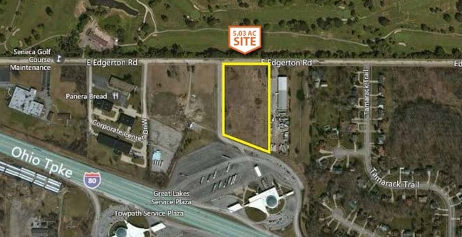
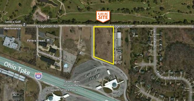
3001 E Edgerton Rd, Broadview Hts, OH 44147

Property Detail
3001 E Edgerton Rd
Cleveland-Elyria, OH
52 WP 729.40FT EP EST 670D
585-19-004
CUYAHOGA
Industrialacreage
Ohio
E-2
52
B and X Area of moderate flood hazard, usually the area between the limits of the 100-year and 500-year floods.
5.03 AC
2025
South
2025
Cleveland
136104
NEARBY LISTINGS FOR SALE OR LEASE
-
-
-
-
-
No Photo
-
View all Broadview Hts listings for sale on LoopNet.com
DEMOGRAPHICS near 3001 E Edgerton Rd
1 mile
3 mile
5 mile
2025 Total Population
2,538
26,965
66,819
2030 Population
2,518
26,772
66,084
Pop Growth 2025-2030
(0.79%)
(0.72%)
(1.10%)
Average Age
40
43
44
2025 Total Households
867
10,916
27,155
HH Growth 2025-2030
(0.92%)
(0.86%)
(1.22%)
Median Household Inc
$157,051
$110,279
$104,500
Avg Household Size
2.80
2.40
2.40
2025 Avg HH Vehicles
2.00
2.00
2.00
Median Home Value
$379,786
$359,417
$331,973
Median Year Built
2000
1985
1979
Nearby Places
Map Layers
Map Styles
 Street
 Aerial
Layers
 Traffic
 Biking
Places
Listings with unknown addresses are not visible on the map
- Restaurants
- Banks
- Shops
- Fitness
- Groceries
PUBLIC TRANSPORTATION
COMMUTER RAIL
Drive
Walk
Distance
14 min
6.1 mi
Drive
Walk
Distance
19 min
7.8 mi
AIRPORT
Cleveland-Hopkins International
Drive
Walk
Distance
Cleveland-Hopkins International
34 min
18.7 mi
Akron-Canton Regional
Drive
Walk
Distance
Akron-Canton Regional
49 min
36.6 mi
SALE & LEASE HISTORY
LISTING DATE
SALE/LEASE

Sep 24, 2016
For Sale
Nearby Properties
Address
Land Use
TOTAL SIZE
Lot Size
Zoning
Address
Land Use
TOTAL SIZE
Lot Size
Zoning
105,027 SF
14.05 AC
O-L
Address
Land Use
TOTAL SIZE
Lot Size
Zoning
154,702 SF
23.37 AC
PF
Address
Land Use
TOTAL SIZE
Lot Size
Zoning
285,065 SF
5.43 AC
D-1
Address
Land Use
TOTAL SIZE
Lot Size
Zoning
105,106 SF
20.67 AC
C-F
Address
Land Use
TOTAL SIZE
Lot Size
Zoning
166,699 SF
65.80 AC
B-5
Address
Land Use
TOTAL SIZE
Lot Size
Zoning
306,640 SF
19.15 AC
M-D
Address
Land Use
TOTAL SIZE
Lot Size
Zoning
48,682 SF
4.64 AC
C-4
Address
Land Use
TOTAL SIZE
Lot Size
Zoning
63,282 SF
20.09 AC
O-B
Address
Land Use
TOTAL SIZE
Lot Size
Zoning
28,189 SF
15.33 AC
B-1OR2
Address
Land Use
TOTAL SIZE
Lot Size
Zoning
73.13 AC
C-F
Address
Land Use
TOTAL SIZE
Lot Size
Zoning
6,395 SF
0.23 AC
O-L
Address
Land Use
TOTAL SIZE
Lot Size
Zoning
207,280 SF
18.60 AC
M-D
Address
Land Use
TOTAL SIZE
Lot Size
Zoning
337,568 SF
26.88 AC
O-L
Address
Land Use
TOTAL SIZE
Lot Size
Zoning
188,503 SF
23.72 AC
D-1
Address
Land Use
TOTAL SIZE
Lot Size
Zoning
24,900 SF
4.42 AC
B-1OR2
Address
Land Use
TOTAL SIZE
Lot Size
Zoning
55,332 SF
3.01 AC
E-2
Address
Land Use
TOTAL SIZE
Lot Size
Zoning
89,807 SF
7.29 AC
Address
Land Use
TOTAL SIZE
Lot Size
Zoning
49,470 SF
6.61 AC
E-1
Address
Land Use
TOTAL SIZE
Lot Size
Zoning
83,495 SF
9.70 AC
E-1
Address
Land Use
TOTAL SIZE
Lot Size
Zoning
131,001 SF
13.47 AC
Address
Land Use
TOTAL SIZE
Lot Size
Zoning
74,531 SF
19.01 AC
C-F
Address
Land Use
TOTAL SIZE
Lot Size
Zoning
167,857 SF
10.60 AC
M-D
Address
Land Use
TOTAL SIZE
Lot Size
Zoning
11.97 AC
R-8
Address
Land Use
TOTAL SIZE
Lot Size
Zoning
183.35 AC
Address
Land Use
TOTAL SIZE
Lot Size
Zoning
142,510 SF
13.87 AC
E-2
Address
Land Use
TOTAL SIZE
Lot Size
Zoning
6.29 AC
L-B
Address
Land Use
TOTAL SIZE
Lot Size
Zoning
25.06 AC
L-B
Address
Land Use
TOTAL SIZE
Lot Size
Zoning
59,813 SF
5.56 AC
Address
Land Use
TOTAL SIZE
Lot Size
Zoning
24.38 AC
L-B
Address
Land Use
TOTAL SIZE
Lot Size
Zoning
49,388 SF
29.19 AC
C-F
The World's #1 Commercial Real Estate Marketplace
Connect with us
© 2026 CoStar Group
The information above has been obtained from sources believed reliable. While we do not doubt its accuracy we have not verified it and make no guarantee, warranty or representation about it. It is your responsibility to independently confirm its accuracy and completeness. Any projections, opinions, assumptions, or estimates used are for example only and do not represent the current or future performance of the property. The value of this transaction to you depends on tax and other factors which should be evaluated by your tax, financial, and legal advisors. You and your advisors should conduct a careful, independent investigation of the property to determine to your satisfaction the suitability of the property for your needs.