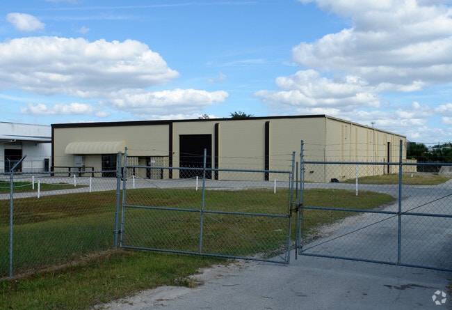
Property Record
3001 Hansrob Rd, Orlando, FL 32804


Save to a Folder
{{folder.Name}}
{{folder.ListingIds.length}} Properties
{{folder.ListingIds.length}} Property
Create a New Folder
Property Detail
3001 Hansrob Rd
09-2229-0000-00-077
S 150 FT OF SE1/4 OF SE1/4 OF SW1/4 OF SE1/4 OF SEC 09-22-29 (LESS R/W)
Warehouse
Orange
I-G/W/RP
Florida
B and X Area of moderate flood hazard, usually the area between the limits of the 100-year and 500-year floods.
77
2025
1.04 AC
2026
NW Orange County
012403
Orlando
15,311 SF
Orlando-Kissimmee-Sanford, FL
NEARBY LISTINGS FOR SALE OR LEASE
DEMOGRAPHICS near 3001 Hansrob Rd
1 mile
3 mile
5 mile
2025 Total Population
4,245
99,931
311,748
2030 Population
4,694
109,246
339,406
Pop Growth 2025-2030
+ 10.58%
+ 9.32%
+ 8.87%
Average Age
43
39
39
2025 Total Households
1,798
40,305
126,075
HH Growth 2025-2030
+ 10.90%
+ 9.96%
+ 9.48%
Median Household Inc
$87,612
$59,681
$67,092
Avg Household Size
2.30
2.40
2.40
2025 Avg HH Vehicles
2.00
2.00
2.00
Median Home Value
$538,008
$348,952
$365,381
Median Year Built
1978
1978
1982
Nearby Places
Map Layers
Map Styles
 Street
 Aerial
Layers
 Traffic
 Biking
Places
Listings with unknown addresses are not visible on the map
- Restaurants
- Banks
- Shops
- Fitness
- Groceries
PUBLIC TRANSPORTATION
COMMUTER RAIL
Drive
Walk
Distance
8 min
3.5 mi
Drive
Walk
Distance
10 min
4.0 mi
AIRPORT
Orlando International
Drive
Walk
Distance
Orlando International
28 min
16.9 mi
Orlando Sanford International
Drive
Walk
Distance
Orlando Sanford International
38 min
23.4 mi
Freight Ports
Port Canaveral
Drive
Walk
Distance
Port Canaveral
73 min
58.9 mi
SALE & LEASE HISTORY
LISTING DATE
SALE/LEASE

Apr 25, 2018
For Sale
Nearby Properties
Address
Land Use
TOTAL SIZE
Lot Size
Zoning
Address
Land Use
TOTAL SIZE
Lot Size
Zoning
2,093,075 SF
57.25 AC
PD/T
Address
Land Use
TOTAL SIZE
Lot Size
Zoning
2,113,867 SF
19.88 AC
P
Address
Land Use
TOTAL SIZE
Lot Size
Zoning
1,182,342 SF
6.90 AC
MU-2/T/SP
Address
Land Use
TOTAL SIZE
Lot Size
Zoning
855,665 SF
75.29 AC
P/T/W
Address
Land Use
TOTAL SIZE
Lot Size
Zoning
689,476 SF
2.54 AC
PD/T
Address
Land Use
TOTAL SIZE
Lot Size
Zoning
537,282 SF
99.45 AC
PD/W
Address
Land Use
TOTAL SIZE
Lot Size
Zoning
324,200 SF
1.02 AC
PD/T
Address
Land Use
TOTAL SIZE
Lot Size
Zoning
1,140,405 SF
78.07 AC
I-P/RP/W
Address
Land Use
TOTAL SIZE
Lot Size
Zoning
567,355 SF
1.41 AC
PD/T/PH
Address
Land Use
TOTAL SIZE
Lot Size
Zoning
507,541 SF
49.48 AC
I-1
Address
Land Use
TOTAL SIZE
Lot Size
Zoning
597,657 SF
2.17 AC
MU-2/T/SP
Address
Land Use
TOTAL SIZE
Lot Size
Zoning
295,128 SF
83.05 AC
PD/W
Address
Land Use
TOTAL SIZE
Lot Size
Zoning
153,319 SF
0.99 AC
PD/T
Address
Land Use
TOTAL SIZE
Lot Size
Zoning
586,427 SF
A-ORL-PD/W
Address
Land Use
TOTAL SIZE
Lot Size
Zoning
468,073 SF
PD/T
Address
Land Use
TOTAL SIZE
Lot Size
Zoning
501,267 SF
PD/T/PH
Address
Land Use
TOTAL SIZE
Lot Size
Zoning
702,450 SF
44.60 AC
R-1A
Address
Land Use
TOTAL SIZE
Lot Size
Zoning
650,065 SF
1.60 AC
PD/T/PH
Address
Land Use
TOTAL SIZE
Lot Size
Zoning
508,038 SF
5.98 AC
PD
Address
Land Use
TOTAL SIZE
Lot Size
Zoning
561,228 SF
5.70 AC
PD/T
Address
Land Use
TOTAL SIZE
Lot Size
Zoning
539,652 SF
5.82 AC
PD/W
Address
Land Use
TOTAL SIZE
Lot Size
Zoning
394,113 SF
1.81 AC
PD/T/PH
Address
Land Use
TOTAL SIZE
Lot Size
Zoning
635,525 SF
7.49 AC
P/T/PH
Address
Land Use
TOTAL SIZE
Lot Size
Zoning
334,225 SF
13.73 AC
P/T/PH
Address
Land Use
TOTAL SIZE
Lot Size
Zoning
231,458 SF
14.29 AC
AC-2
Address
Land Use
TOTAL SIZE
Lot Size
Zoning
580,860 SF
2.59 AC
AC-3A/T
Address
Land Use
TOTAL SIZE
Lot Size
Zoning
501,105 SF
4.82 AC
AC-3A/T
Address
Land Use
TOTAL SIZE
Lot Size
Zoning
838,104 SF
5.66 AC
AC-3A/T
Address
Land Use
TOTAL SIZE
Lot Size
Zoning
239,964 SF
5.45 AC
R-3B/W
Address
Land Use
TOTAL SIZE
Lot Size
Zoning
442,076 SF
3.43 AC
PD/T
The World's #1 Commercial Real Estate Marketplace
Connect with us
© 2026 CoStar Group
The information above has been obtained from sources believed reliable. While we do not doubt its accuracy we have not verified it and make no guarantee, warranty or representation about it. It is your responsibility to independently confirm its accuracy and completeness. Any projections, opinions, assumptions, or estimates used are for example only and do not represent the current or future performance of the property. The value of this transaction to you depends on tax and other factors which should be evaluated by your tax, financial, and legal advisors. You and your advisors should conduct a careful, independent investigation of the property to determine to your satisfaction the suitability of the property for your needs.