Property Record
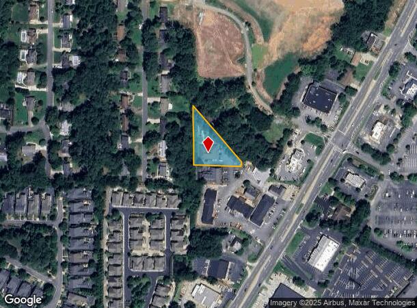
3001 Johnson Ferry Rd, Marietta, GA 30062
This Property Is For Sale
NEARBY LISTINGS FOR SALE OR LEASE
Property Detail
3001 Johnson Ferry Rd
Atlanta-Sandy Springs-Roswell, GA
David A & Sherry A Stuart Surv
16-0470-0-033-0
2973&2793 JOHNSON FERRY ROAD LL470&539
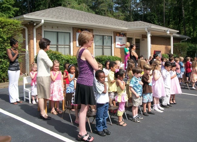
Daycare
Cobb
X
Georgia
13057C0375E
470
2025
0.77 AC
2025
Town Center/Marietta
030359
Atlanta
4,800 SF
DEMOGRAPHICS near 3001 Johnson Ferry Rd
1 Mile
3 Mile
5 Mile
2024 Total Population
8,052
64,942
170,983
2029 Population
8,106
65,427
174,224
Pop Growth 2024-2029
+ 0.67%
+ 0.75%
+ 1.90%
Average Age
43
41
42
2024 Total Households
2,801
21,756
61,482
HH Growth 2024-2029
+ 0.64%
+ 0.75%
+ 2.02%
Median Household Inc
$170,799
$161,534
$136,753
Avg Household Size
2.80
2.90
2.70
2024 Avg HH Vehicles
2.00
2.00
2.00
Median Home Value
$495,500
$494,186
$462,811
Median Year Built
1984
1984
1985
Nearby Places
- Restaurants
- Banks
- Shops
- Fitness
- Groceries
PUBLIC TRANSPORTATION
AIRPORT
Hartsfield - Jackson Atlanta International
DRIVE
WALK
Distance
Hartsfield - Jackson Atlanta International
51 min
33.9 mi
Nearby Properties
Address
Land Use
TOTAL SIZE
Lot Size
Zoning
Address
Land Use
TOTAL SIZE
Lot Size
Zoning
258,955 SF
29.70 AC
CRC/LRO
Address
Land Use
TOTAL SIZE
Lot Size
Zoning
1,198,136 SF
30.94 AC
E2
Address
Land Use
TOTAL SIZE
Lot Size
Zoning
166,048 SF
20.29 AC
GC
Address
Land Use
TOTAL SIZE
Lot Size
Zoning
194,453 SF
17.71 AC
CRC/WS
Address
Land Use
TOTAL SIZE
Lot Size
Zoning
118,464 SF
15.73 AC
CRC
Address
Land Use
TOTAL SIZE
Lot Size
Zoning
139,694 SF
16.35 AC
GC/WS
Address
Land Use
TOTAL SIZE
Lot Size
Zoning
119,776 SF
11.17 AC
NS/WS
Address
Land Use
TOTAL SIZE
Lot Size
Zoning
91,439 SF
10 AC
C3
Address
Land Use
TOTAL SIZE
Lot Size
Zoning
113,274 SF
14.30 AC
NRC
Address
Land Use
TOTAL SIZE
Lot Size
Zoning
96,575 SF
14.19 AC
CRC
Address
Land Use
TOTAL SIZE
Lot Size
Zoning
37.22 AC
RS30
Address
Land Use
TOTAL SIZE
Lot Size
Zoning
9,840 SF
9.76 AC
CRC
Address
Land Use
TOTAL SIZE
Lot Size
Zoning
239,207 SF
8.78 AC
GC/WS
Address
Land Use
TOTAL SIZE
Lot Size
Zoning
44,346 SF
4.46 AC
CRC
Address
Land Use
TOTAL SIZE
Lot Size
Zoning
128,491 SF
9.09 AC
OI
Address
Land Use
TOTAL SIZE
Lot Size
Zoning
41,268 SF
13.78 AC
Address
Land Use
TOTAL SIZE
Lot Size
Zoning
138,200 SF
17.70 AC
CRC/WS
Address
Land Use
TOTAL SIZE
Lot Size
Zoning
90,942 SF
1.33 AC
NRC/WS
Address
Land Use
TOTAL SIZE
Lot Size
Zoning
121,844 SF
17.61 AC
CRC/WS
Address
Land Use
TOTAL SIZE
Lot Size
Zoning
56,868 SF
6.41 AC
CRC
Address
Land Use
TOTAL SIZE
Lot Size
Zoning
105,216 SF
10.42 AC
GC
Address
Land Use
TOTAL SIZE
Lot Size
Zoning
109,792 SF
2.56 AC
CRC
Address
Land Use
TOTAL SIZE
Lot Size
Zoning
87,132 SF
7.10 AC
PSC
Address
Land Use
TOTAL SIZE
Lot Size
Zoning
48,189 SF
5.87 AC
PSC
Address
Land Use
TOTAL SIZE
Lot Size
Zoning
50,537 SF
3.73 AC
OI
Address
Land Use
TOTAL SIZE
Lot Size
Zoning
33,410 SF
4.54 AC
GC/WS
Address
Land Use
TOTAL SIZE
Lot Size
Zoning
12,800 SF
3.87 AC
GC
Address
Land Use
TOTAL SIZE
Lot Size
Zoning
91,264 SF
8.59 AC
CRC/WS
Address
Land Use
TOTAL SIZE
Lot Size
Zoning
79,905 SF
3.39 AC
NRC
Address
Land Use
TOTAL SIZE
Lot Size
Zoning
2.78 AC
OI
The World's #1 Commercial Real Estate Marketplace
Connect with us
© 2025 CoStar Group
The information above has been obtained from sources believed reliable. While we do not doubt its accuracy we have not verified it and make no guarantee, warranty or representation about it. It is your responsibility to independently confirm its accuracy and completeness. Any projections, opinions, assumptions, or estimates used are for example only and do not represent the current or future performance of the property. The value of this transaction to you depends on tax and other factors which should be evaluated by your tax, financial, and legal advisors. You and your advisors should conduct a careful, independent investigation of the property to determine to your satisfaction the suitability of the property for your needs.