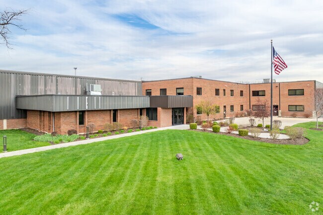
Property Record
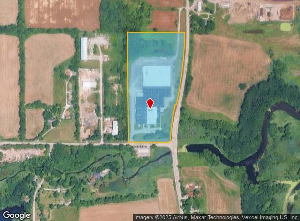
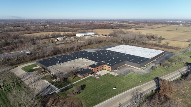
3001 Darrell Rd, Island Lake, IL 60042
Current Lease Availabilities
NEARBY LISTINGS FOR SALE OR LEASE
Property Detail
3001 Darrell Rd
Chicago-Naperville-Elgin, IL-IN-WI
School Trustees Sub
09-16-400-019
SCHOOL TRUSTEES SUB; THAT PRT LTS 21 & 22 LYG WLY OF CEN LN OF HWY ALSO E 66 OF LTS 20 & 23 (EX PRT DAFS; COM SE COR SE C 16, WLY ALG S LN 170.30 TO CL OF DARRELL RD, NLY ALG CL O
Industrialgeneral
Lake
AE
Illinois
17097C0116K
20-23
2023
20.06 AC
2024
South Lake County
864203
Chicago
212,880 SF
DEMOGRAPHICS near 3001 Darrell Rd
1 Mile
3 Mile
5 Mile
2024 Total Population
2,035
25,997
65,235
2029 Population
2,005
25,695
64,822
Pop Growth 2024-2029
(1.47%)
(1.16%)
(0.63%)
Average Age
41
40
41
2024 Total Households
753
9,813
24,359
HH Growth 2024-2029
(1.59%)
(1.19%)
(0.63%)
Median Household Inc
$88,225
$91,652
$98,785
Avg Household Size
2.70
2.60
2.60
2024 Avg HH Vehicles
2.00
2.00
2.00
Median Home Value
$259,999
$242,574
$270,663
Median Year Built
1979
1987
1991
Nearby Places
Map Layers
Map Styles
 Street
 Aerial
- Restaurants
- Banks
- Shops
- Fitness
- Groceries
PUBLIC TRANSPORTATION
COMMUTER RAIL
Cary Station (Union Pacific Northwest Line - Northeast Illinois Regional Commuter Railroad (Metra))
DRIVE
WALK
Distance
Cary Station (Union Pacific Northwest Line - Northeast Illinois Regional Commuter Railroad (Metra))
19 min
8.2 mi
AIRPORT
Chicago O'Hare International
DRIVE
WALK
Distance
Chicago O'Hare International
49 min
34.0 mi
Freight Ports
Port Milwaukee
DRIVE
WALK
Distance
Port Milwaukee
85 min
65.6 mi
Nearby Properties
Address
Land Use
TOTAL SIZE
Lot Size
Zoning
Address
Land Use
TOTAL SIZE
Lot Size
Zoning
220,060 SF
11.75 AC
Address
Land Use
TOTAL SIZE
Lot Size
Zoning
68,132 SF
1.96 AC
Address
Land Use
TOTAL SIZE
Lot Size
Zoning
241,227 SF
15.79 AC
Address
Land Use
TOTAL SIZE
Lot Size
Zoning
32.23 AC
Address
Land Use
TOTAL SIZE
Lot Size
Zoning
114,186 SF
17.14 AC
Address
Land Use
TOTAL SIZE
Lot Size
Zoning
258,252 SF
1.97 AC
Address
Land Use
TOTAL SIZE
Lot Size
Zoning
118,869 SF
5.88 AC
Address
Land Use
TOTAL SIZE
Lot Size
Zoning
448,000 SF
8.28 AC
Address
Land Use
TOTAL SIZE
Lot Size
Zoning
521,479 SF
6.20 AC
Address
Land Use
TOTAL SIZE
Lot Size
Zoning
1,525,750 SF
7.55 AC
Address
Land Use
TOTAL SIZE
Lot Size
Zoning
302,400 SF
7.37 AC
Address
Land Use
TOTAL SIZE
Lot Size
Zoning
81,478 SF
9.25 AC
Address
Land Use
TOTAL SIZE
Lot Size
Zoning
34,600 SF
2.91 AC
Address
Land Use
TOTAL SIZE
Lot Size
Zoning
54,572 SF
4.97 AC
Address
Land Use
TOTAL SIZE
Lot Size
Zoning
100,000 SF
5.13 AC
Address
Land Use
TOTAL SIZE
Lot Size
Zoning
77,881 SF
4.60 AC
Address
Land Use
TOTAL SIZE
Lot Size
Zoning
26,896 SF
4.03 AC
Address
Land Use
TOTAL SIZE
Lot Size
Zoning
18,873 SF
159.95 AC
Address
Land Use
TOTAL SIZE
Lot Size
Zoning
123,948 SF
4 AC
Address
Land Use
TOTAL SIZE
Lot Size
Zoning
56,042 SF
1.15 AC
Address
Land Use
TOTAL SIZE
Lot Size
Zoning
4,256 SF
6.62 AC
Address
Land Use
TOTAL SIZE
Lot Size
Zoning
99,256 SF
2 AC
Address
Land Use
TOTAL SIZE
Lot Size
Zoning
56,566 SF
1.86 AC
Address
Land Use
TOTAL SIZE
Lot Size
Zoning
44,952 SF
3.26 AC
Address
Land Use
TOTAL SIZE
Lot Size
Zoning
163,800 SF
5 AC
Address
Land Use
TOTAL SIZE
Lot Size
Zoning
71,007 SF
7.02 AC
Address
Land Use
TOTAL SIZE
Lot Size
Zoning
70,062 SF
12.03 AC
Address
Land Use
TOTAL SIZE
Lot Size
Zoning
129,600 SF
17.05 AC
Address
Land Use
TOTAL SIZE
Lot Size
Zoning
13,833 SF
1.54 AC
The World's #1 Commercial Real Estate Marketplace
Connect with us
© 2026 CoStar Group
The information above has been obtained from sources believed reliable. While we do not doubt its accuracy we have not verified it and make no guarantee, warranty or representation about it. It is your responsibility to independently confirm its accuracy and completeness. Any projections, opinions, assumptions, or estimates used are for example only and do not represent the current or future performance of the property. The value of this transaction to you depends on tax and other factors which should be evaluated by your tax, financial, and legal advisors. You and your advisors should conduct a careful, independent investigation of the property to determine to your satisfaction the suitability of the property for your needs.