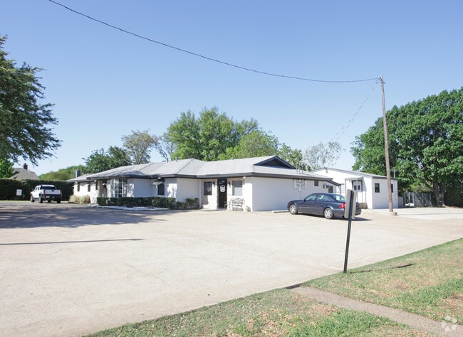
Property Record
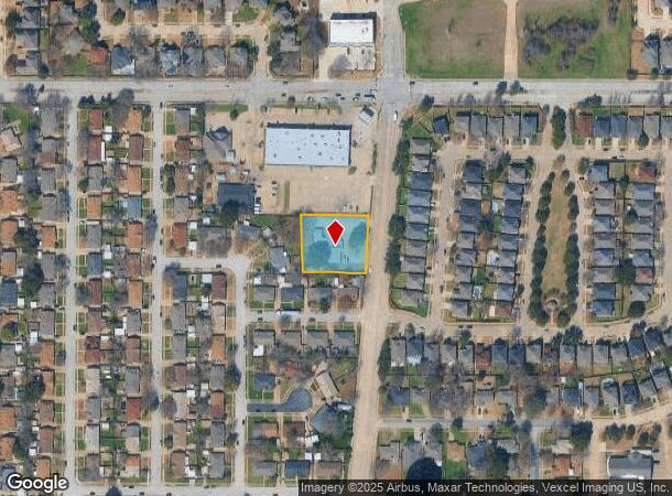
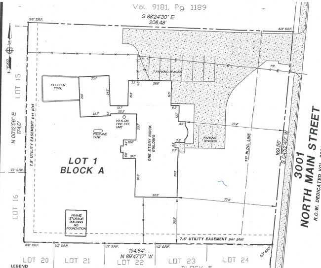
3001 N Main St, Fort Worth, TX 76106

NEARBY LISTINGS FOR SALE OR LEASE
Property Detail
3001 N Main St
Dallas-Fort Worth-Arlington, TX
Pac Addition
06475019
PAC ADDITION BLOCK A LOT 1
Commercialnec
Tarrant
X
Texas
48113C0150K
1
2024
0.79 AC
2025
HEB/Mid-Cities
100300
Dallas/Ft Worth
3,378 SF
DEMOGRAPHICS near 3001 N Main St
1 Mile
3 Mile
5 Mile
2024 Total Population
13,411
73,235
190,196
2029 Population
14,061
76,815
198,926
Pop Growth 2024-2029
+ 4.85%
+ 4.89%
+ 4.59%
Average Age
39
39
39
2024 Total Households
5,137
29,813
77,862
HH Growth 2024-2029
+ 4.75%
+ 4.95%
+ 4.55%
Median Household Inc
$102,844
$88,691
$79,159
Avg Household Size
2.60
2.40
2.40
2024 Avg HH Vehicles
2.00
2.00
2.00
Median Home Value
$347,940
$373,169
$364,959
Median Year Built
1988
1988
1987
Nearby Places
Map Layers
Map Styles
 Street
 Aerial
- Restaurants
- Banks
- Shops
- Fitness
- Groceries
PUBLIC TRANSPORTATION
COMMUTER RAIL
Centre Port/DFW (Trinity Railway Express - Dallas Area Rapid Transit (DART))
DRIVE
WALK
Distance
Centre Port/DFW (Trinity Railway Express - Dallas Area Rapid Transit (DART))
10 min
5.7 mi
DRIVE
WALK
Distance
16 min
7.4 mi
AIRPORT
Dallas-Fort Worth International
DRIVE
WALK
Distance
Dallas-Fort Worth International
13 min
6.8 mi
Dallas Love Field
DRIVE
WALK
Distance
Dallas Love Field
28 min
18.9 mi
SALE & LEASE HISTORY
LISTING DATE
SALE/LEASE

Mar 30, 2021
For Sale
Dec 08, 2017
For Sale
Nearby Properties
Address
Land Use
TOTAL SIZE
Lot Size
Zoning
Address
Land Use
TOTAL SIZE
Lot Size
Zoning
3,604,594 SF
490.43 AC
Address
Land Use
TOTAL SIZE
Lot Size
Zoning
624,642 SF
15.38 AC
Address
Land Use
TOTAL SIZE
Lot Size
Zoning
631,558 SF
15.49 AC
Address
Land Use
TOTAL SIZE
Lot Size
Zoning
394,769 SF
20.39 AC
Address
Land Use
TOTAL SIZE
Lot Size
Zoning
394,769 SF
20.36 AC
Address
Land Use
TOTAL SIZE
Lot Size
Zoning
468,250 SF
37.03 AC
Address
Land Use
TOTAL SIZE
Lot Size
Zoning
630,765 SF
321.80 AC
Address
Land Use
TOTAL SIZE
Lot Size
Zoning
401,397 SF
14.94 AC
Address
Land Use
TOTAL SIZE
Lot Size
Zoning
419,655 SF
20.44 AC
Address
Land Use
TOTAL SIZE
Lot Size
Zoning
443,420 SF
10.96 AC
Address
Land Use
TOTAL SIZE
Lot Size
Zoning
333,755 SF
19.06 AC
Address
Land Use
TOTAL SIZE
Lot Size
Zoning
321,993 SF
18.20 AC
Address
Land Use
TOTAL SIZE
Lot Size
Zoning
264,000 SF
15.06 AC
Address
Land Use
TOTAL SIZE
Lot Size
Zoning
345,961 SF
14.73 AC
Address
Land Use
TOTAL SIZE
Lot Size
Zoning
234,200 SF
274.75 AC
Address
Land Use
TOTAL SIZE
Lot Size
Zoning
344,326 SF
15.25 AC
Address
Land Use
TOTAL SIZE
Lot Size
Zoning
324.32 AC
Address
Land Use
TOTAL SIZE
Lot Size
Zoning
220,435 SF
14.97 AC
Address
Land Use
TOTAL SIZE
Lot Size
Zoning
230,666 SF
13.33 AC
Address
Land Use
TOTAL SIZE
Lot Size
Zoning
293,822 SF
18.80 AC
Address
Land Use
TOTAL SIZE
Lot Size
Zoning
300,000 SF
27.13 AC
Address
Land Use
TOTAL SIZE
Lot Size
Zoning
286,861 SF
13.38 AC
Address
Land Use
TOTAL SIZE
Lot Size
Zoning
236,016 SF
12.81 AC
Address
Land Use
TOTAL SIZE
Lot Size
Zoning
199,373 SF
12.98 AC
Address
Land Use
TOTAL SIZE
Lot Size
Zoning
214,908 SF
13.55 AC
Address
Land Use
TOTAL SIZE
Lot Size
Zoning
269,700 SF
48.40 AC
Address
Land Use
TOTAL SIZE
Lot Size
Zoning
198,800 SF
6.74 AC
Address
Land Use
TOTAL SIZE
Lot Size
Zoning
234,077 SF
12.16 AC
Address
Land Use
TOTAL SIZE
Lot Size
Zoning
921,172 SF
105 AC
Address
Land Use
TOTAL SIZE
Lot Size
Zoning
257,108 SF
14.98 AC
The World's #1 Commercial Real Estate Marketplace
Connect with us
© 2025 CoStar Group
The information above has been obtained from sources believed reliable. While we do not doubt its accuracy we have not verified it and make no guarantee, warranty or representation about it. It is your responsibility to independently confirm its accuracy and completeness. Any projections, opinions, assumptions, or estimates used are for example only and do not represent the current or future performance of the property. The value of this transaction to you depends on tax and other factors which should be evaluated by your tax, financial, and legal advisors. You and your advisors should conduct a careful, independent investigation of the property to determine to your satisfaction the suitability of the property for your needs.