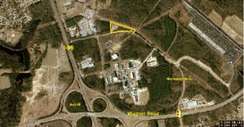
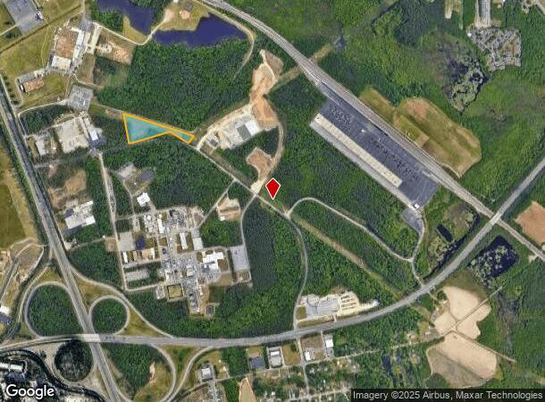
Property Record
3001 N Normandy Dr, Petersburg, VA 23805
NEARBY LISTINGS FOR SALE OR LEASE
Property Detail
3001 N Normandy Dr
Richmond, VA
Frontage Road Industrial Park
064-03-0003
INDUSTRIAL PARK PARCEL C3.50 ACRES
Industrialacreage
Petersburg
X
Virginia
51149C0155C
5.51 AC
2023
TriCities
2025
Richmond VA
811200
DEMOGRAPHICS near 3001 N Normandy Dr
1 Mile
3 Mile
5 Mile
2024 Total Population
2,146
22,510
61,850
2029 Population
2,074
22,254
62,174
Pop Growth 2024-2029
(3.36%)
(1.14%)
+ 0.52%
Average Age
41
38
37
2024 Total Households
966
8,909
23,505
HH Growth 2024-2029
(3.83%)
(1.64%)
+ 0.30%
Median Household Inc
$56,891
$58,852
$52,705
Avg Household Size
2.10
2.40
2.30
2024 Avg HH Vehicles
2.00
2.00
2.00
Median Home Value
$145,914
$164,666
$162,463
Median Year Built
1998
1976
1973
Nearby Places
Map Layers
Map Styles
 Street
 Aerial
- Restaurants
- Banks
- Shops
- Fitness
- Groceries
PUBLIC TRANSPORTATION
COMMUTER RAIL
Petersburg Amtrak Station (Carolinian - Amtrak, Northeast Regional - Amtrak, Palmetto - Amtrak, Silver Meteor - Amtrak, Silver Star - Amtrak)
DRIVE
WALK
Distance
Petersburg Amtrak Station (Carolinian - Amtrak, Northeast Regional - Amtrak, Palmetto - Amtrak, Silver Meteor - Amtrak, Silver Star - Amtrak)
12 min
7.0 mi
AIRPORT
Richmond International
DRIVE
WALK
Distance
Richmond International
41 min
31.5 mi
Freight Ports
Virginia Port Authority - Richmond
DRIVE
WALK
Distance
Virginia Port Authority - Richmond
33 min
23.2 mi
Nearby Properties
Address
Land Use
TOTAL SIZE
Lot Size
Zoning
Address
Land Use
TOTAL SIZE
Lot Size
Zoning
24.02 AC
B-2C
Address
Land Use
TOTAL SIZE
Lot Size
Zoning
28.17 AC
PUD
Address
Land Use
TOTAL SIZE
Lot Size
Zoning
359,504 SF
32.59 AC
R-4
Address
Land Use
TOTAL SIZE
Lot Size
Zoning
17.09 AC
PUD
Address
Land Use
TOTAL SIZE
Lot Size
Zoning
498.93 AC
Address
Land Use
TOTAL SIZE
Lot Size
Zoning
264,335 SF
70 AC
M-2
Address
Land Use
TOTAL SIZE
Lot Size
Zoning
11.57 AC
PUD
Address
Land Use
TOTAL SIZE
Lot Size
Zoning
205,626 SF
151.04 AC
M-2
Address
Land Use
TOTAL SIZE
Lot Size
Zoning
407,650 SF
136.67 AC
M-2
Address
Land Use
TOTAL SIZE
Lot Size
Zoning
252,133 SF
14.59 AC
Address
Land Use
TOTAL SIZE
Lot Size
Zoning
65,214 SF
8.46 AC
R-4
Address
Land Use
TOTAL SIZE
Lot Size
Zoning
51,463 SF
15.18 AC
I1
Address
Land Use
TOTAL SIZE
Lot Size
Zoning
62,104 SF
20 AC
I1
Address
Land Use
TOTAL SIZE
Lot Size
Zoning
42,561 SF
6.91 AC
B-2C
Address
Land Use
TOTAL SIZE
Lot Size
Zoning
151,980 SF
23.12 AC
PUD
Address
Land Use
TOTAL SIZE
Lot Size
Zoning
149,472 SF
14.68 AC
R-4
Address
Land Use
TOTAL SIZE
Lot Size
Zoning
8.72 AC
PUD
Address
Land Use
TOTAL SIZE
Lot Size
Zoning
1.09 AC
PUD
Address
Land Use
TOTAL SIZE
Lot Size
Zoning
182,760 SF
10.50 AC
R-4
Address
Land Use
TOTAL SIZE
Lot Size
Zoning
46,802 SF
14.50 AC
R-2
Address
Land Use
TOTAL SIZE
Lot Size
Zoning
102,424 SF
14.71 AC
PUD
Address
Land Use
TOTAL SIZE
Lot Size
Zoning
84,064 SF
15.54 AC
PUD
Address
Land Use
TOTAL SIZE
Lot Size
Zoning
128,816 SF
26.11 AC
I1
Address
Land Use
TOTAL SIZE
Lot Size
Zoning
33,360 SF
0.45 AC
B-2C
Address
Land Use
TOTAL SIZE
Lot Size
Zoning
960 SF
13.24 AC
B-1
Address
Land Use
TOTAL SIZE
Lot Size
Zoning
143,904 SF
14.44 AC
Address
Land Use
TOTAL SIZE
Lot Size
Zoning
2,880 SF
0.02 AC
A
Address
Land Use
TOTAL SIZE
Lot Size
Zoning
141,182 SF
7.62 AC
R-4
Address
Land Use
TOTAL SIZE
Lot Size
Zoning
44,311 SF
9.05 AC
R-1
Address
Land Use
TOTAL SIZE
Lot Size
Zoning
8 AC
PUD
The World's #1 Commercial Real Estate Marketplace
Connect with us
© 2025 CoStar Group
The information above has been obtained from sources believed reliable. While we do not doubt its accuracy we have not verified it and make no guarantee, warranty or representation about it. It is your responsibility to independently confirm its accuracy and completeness. Any projections, opinions, assumptions, or estimates used are for example only and do not represent the current or future performance of the property. The value of this transaction to you depends on tax and other factors which should be evaluated by your tax, financial, and legal advisors. You and your advisors should conduct a careful, independent investigation of the property to determine to your satisfaction the suitability of the property for your needs.