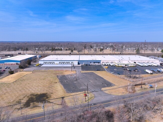
Property Record
3001 State Rd, Bensalem, PA 19020

Current Lease Availabilities
Property Detail
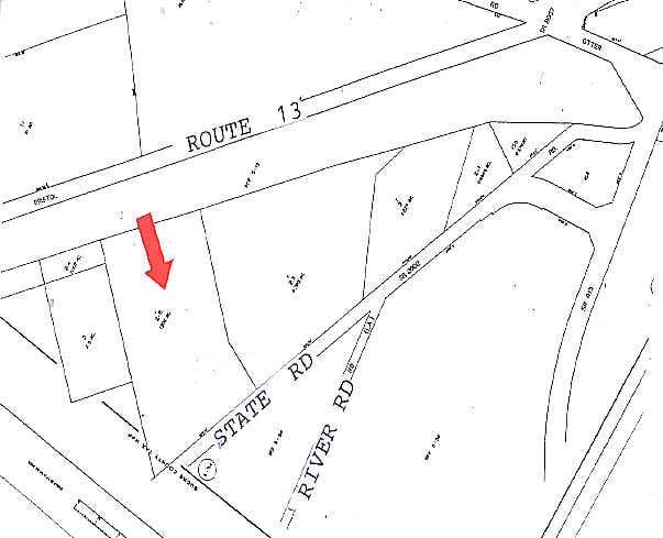
3001 State Rd
05-058-002-002
7.632A LOT #1 PLAN FOR ROHM & HAAS C O
Warehouse
BUCKS
M2
Pennsylvania
B and X Area of moderate flood hazard, usually the area between the limits of the 100-year and 500-year floods.
1
2024
7.63 AC
2025
Bucks
100102
Philadelphia
100,276 SF
Philadelphia-Camden-Wilmington, PA-NJ-DE-MD
NEARBY LISTINGS FOR SALE OR LEASE
DEMOGRAPHICS near 3001 State Rd
1 mile
3 mile
5 mile
2024 Total Population
7,557
75,709
228,050
2029 Population
7,532
76,482
230,636
Pop Growth 2024-2029
(0.33%)
+ 1.02%
+ 1.13%
Average Age
42
41
42
2024 Total Households
2,799
29,071
85,962
HH Growth 2024-2029
(0.43%)
+ 1.01%
+ 1.16%
Median Household Inc
$70,229
$76,541
$86,576
Avg Household Size
2.60
2.50
2.60
2024 Avg HH Vehicles
2.00
2.00
2.00
Median Home Value
$275,949
$297,694
$322,537
Median Year Built
1957
1961
1965
Nearby Places
Map Layers
Map Styles
 Street
 Aerial
Transit
 Traffic
 Biking
Places
Listings with unknown addresses are not visible on the map
- Restaurants
- Banks
- Shops
- Fitness
- Groceries
Nearby Properties
Address
Land Use
TOTAL SIZE
Lot Size
Zoning
Address
Land Use
TOTAL SIZE
Lot Size
Zoning
77.35 AC
I-2
Address
Land Use
TOTAL SIZE
Lot Size
Zoning
2,019 SF
28.85 AC
I-2
Address
Land Use
TOTAL SIZE
Lot Size
Zoning
22,688 SF
32.55 AC
BLI1
Address
Land Use
TOTAL SIZE
Lot Size
Zoning
19,188 SF
29.52 AC
Address
Land Use
TOTAL SIZE
Lot Size
Zoning
16.23 AC
R-3
Address
Land Use
TOTAL SIZE
Lot Size
Zoning
253,500 SF
24.28 AC
BLI1
Address
Land Use
TOTAL SIZE
Lot Size
Zoning
1,325 SF
18.73 AC
Address
Land Use
TOTAL SIZE
Lot Size
Zoning
372,324 SF
17 AC
Address
Land Use
TOTAL SIZE
Lot Size
Zoning
11 AC
TRN
Address
Land Use
TOTAL SIZE
Lot Size
Zoning
Address
Land Use
TOTAL SIZE
Lot Size
Zoning
4,313 SF
1.25 AC
HC-2
Address
Land Use
TOTAL SIZE
Lot Size
Zoning
15.09 AC
I-1
Address
Land Use
TOTAL SIZE
Lot Size
Zoning
29 AC
I-2
Address
Land Use
TOTAL SIZE
Lot Size
Zoning
24,328 SF
16.99 AC
I-2
Address
Land Use
TOTAL SIZE
Lot Size
Zoning
10.73 AC
BLI1
Address
Land Use
TOTAL SIZE
Lot Size
Zoning
148 SF
8.88 AC
B-2
Address
Land Use
TOTAL SIZE
Lot Size
Zoning
8.60 AC
R-1
Address
Land Use
TOTAL SIZE
Lot Size
Zoning
2.43 AC
W-1
Address
Land Use
TOTAL SIZE
Lot Size
Zoning
242 AC
OS-1
Address
Land Use
TOTAL SIZE
Lot Size
Zoning
18.15 AC
I-2
Address
Land Use
TOTAL SIZE
Lot Size
Zoning
32.60 AC
Address
Land Use
TOTAL SIZE
Lot Size
Zoning
8.40 AC
Address
Land Use
TOTAL SIZE
Lot Size
Zoning
63.30 AC
I-1
Address
Land Use
TOTAL SIZE
Lot Size
Zoning
9.15 AC
B2
Address
Land Use
TOTAL SIZE
Lot Size
Zoning
19,518 SF
10.81 AC
I-1
Address
Land Use
TOTAL SIZE
Lot Size
Zoning
10.68 AC
R-3
Address
Land Use
TOTAL SIZE
Lot Size
Zoning
29,251 SF
13.30 AC
B-2
Address
Land Use
TOTAL SIZE
Lot Size
Zoning
38,590 SF
1.82 AC
TRN
Address
Land Use
TOTAL SIZE
Lot Size
Zoning
43,445 SF
5.96 AC
Address
Land Use
TOTAL SIZE
Lot Size
Zoning
1.67 AC
TRN
The World's #1 Commercial Real Estate Marketplace
Connect with us
© 2026 CoStar Group
The information above has been obtained from sources believed reliable. While we do not doubt its accuracy we have not verified it and make no guarantee, warranty or representation about it. It is your responsibility to independently confirm its accuracy and completeness. Any projections, opinions, assumptions, or estimates used are for example only and do not represent the current or future performance of the property. The value of this transaction to you depends on tax and other factors which should be evaluated by your tax, financial, and legal advisors. You and your advisors should conduct a careful, independent investigation of the property to determine to your satisfaction the suitability of the property for your needs.