Property Record
3002 State Highway 20 W, Freeport, FL 32439


This Property Is For Sale
NEARBY LISTINGS FOR SALE OR LEASE
-
-
View all Freeport listings for sale on LoopNet.com
Property Detail
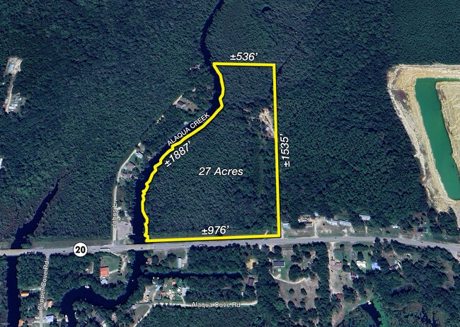
3002 State Highway 20 W
Crestview-Fort Walton Beach-Destin, FL
Alaqua Creek
07-1S-19-23000-021-0030
NW 1/4 E OF ALAQUA CREEK AND N OF HWY 20 ROW SEC 07-1S-19W, MORE PARTICULARLY DESCRIBED AS FOLLOWS: BEG AT NE/C OF THE NW 1/4 OF SAID SEC 07; S ALG E LINE OF SAID NW 1/4 1555 FT MOL TO THE N ROW OF SR 20; S 86 DEG 56'45W ALG SAID ROW, 925 FT MOL TO E
Miscellaneous
Walton
AE
Florida
12131C0420H
30
2025
23.38 AC
2025
Florida Panhandle Area
950306
Other Market Areas
DEMOGRAPHICS near 3002 State Highway 20 W
1 Mile
3 Mile
5 Mile
2024 Total Population
432
4,561
8,280
2029 Population
476
5,037
9,159
Pop Growth 2024-2029
+ 10.19%
+ 10.44%
+ 10.62%
Average Age
39
39
38
2024 Total Households
160
1,659
3,007
HH Growth 2024-2029
+ 8.75%
+ 9.52%
+ 9.78%
Median Household Inc
$75,543
$77,592
$72,368
Avg Household Size
2.60
2.70
2.70
2024 Avg HH Vehicles
2.00
2.00
2.00
Median Home Value
$334,210
$360,550
$352,463
Median Year Built
2010
2010
2010
Nearby Places
Map Layers
Map Styles
 Street
 Aerial
- Restaurants
- Banks
- Shops
- Fitness
- Groceries
PUBLIC TRANSPORTATION
AIRPORT
Eglin AFB/Destin-Ft Walton Beach
DRIVE
WALK
Distance
Eglin AFB/Destin-Ft Walton Beach
56 min
25.9 mi
Northwest Florida Beaches International
DRIVE
WALK
Distance
Northwest Florida Beaches International
50 min
35.0 mi
Freight Ports
Port of Panama City
DRIVE
WALK
Distance
Port of Panama City
67 min
45.7 mi
Nearby Properties
Address
Land Use
TOTAL SIZE
Lot Size
Zoning
Address
Land Use
TOTAL SIZE
Lot Size
Zoning
176,047 SF
29.75 AC
Address
Land Use
TOTAL SIZE
Lot Size
Zoning
334,804 SF
13.94 AC
MUNI
Address
Land Use
TOTAL SIZE
Lot Size
Zoning
311,974 SF
7.28 AC
Address
Land Use
TOTAL SIZE
Lot Size
Zoning
64,883 SF
4.88 AC
GC
Address
Land Use
TOTAL SIZE
Lot Size
Zoning
12,472 SF
10.63 AC
Address
Land Use
TOTAL SIZE
Lot Size
Zoning
16,297 SF
13.93 AC
Address
Land Use
TOTAL SIZE
Lot Size
Zoning
248.65 AC
BYALAQ
Address
Land Use
TOTAL SIZE
Lot Size
Zoning
5,040 SF
36.94 AC
Address
Land Use
TOTAL SIZE
Lot Size
Zoning
21.47 AC
Address
Land Use
TOTAL SIZE
Lot Size
Zoning
9,044 SF
4.40 AC
Address
Land Use
TOTAL SIZE
Lot Size
Zoning
17,562 SF
9.67 AC
Address
Land Use
TOTAL SIZE
Lot Size
Zoning
600 AC
EG
Address
Land Use
TOTAL SIZE
Lot Size
Zoning
18,420 SF
4.51 AC
Address
Land Use
TOTAL SIZE
Lot Size
Zoning
15,925 SF
0.92 AC
MUNI
Address
Land Use
TOTAL SIZE
Lot Size
Zoning
10,624 SF
10 AC
Address
Land Use
TOTAL SIZE
Lot Size
Zoning
15,275 SF
0.92 AC
MUNI
Address
Land Use
TOTAL SIZE
Lot Size
Zoning
8,140 SF
2.50 AC
MUNI
Address
Land Use
TOTAL SIZE
Lot Size
Zoning
10,942 SF
1.19 AC
GC
Address
Land Use
TOTAL SIZE
Lot Size
Zoning
11,464 SF
0.92 AC
MUNI
Address
Land Use
TOTAL SIZE
Lot Size
Zoning
640 AC
EG
Address
Land Use
TOTAL SIZE
Lot Size
Zoning
640 AC
EG
Address
Land Use
TOTAL SIZE
Lot Size
Zoning
924 SF
14.10 AC
BYALAQ
Address
Land Use
TOTAL SIZE
Lot Size
Zoning
Address
Land Use
TOTAL SIZE
Lot Size
Zoning
Address
Land Use
TOTAL SIZE
Lot Size
Zoning
18,154 SF
4.04 AC
Address
Land Use
TOTAL SIZE
Lot Size
Zoning
21,028 SF
3.20 AC
Address
Land Use
TOTAL SIZE
Lot Size
Zoning
Address
Land Use
TOTAL SIZE
Lot Size
Zoning
6,487 SF
0.66 AC
GC
Address
Land Use
TOTAL SIZE
Lot Size
Zoning
0.69 AC
BYALAQ
The World's #1 Commercial Real Estate Marketplace
Connect with us
© 2026 CoStar Group
The information above has been obtained from sources believed reliable. While we do not doubt its accuracy we have not verified it and make no guarantee, warranty or representation about it. It is your responsibility to independently confirm its accuracy and completeness. Any projections, opinions, assumptions, or estimates used are for example only and do not represent the current or future performance of the property. The value of this transaction to you depends on tax and other factors which should be evaluated by your tax, financial, and legal advisors. You and your advisors should conduct a careful, independent investigation of the property to determine to your satisfaction the suitability of the property for your needs.