Property Record
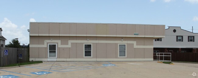
3000 Jean Lafitte Pkwy, Chalmette, LA 70043


Property Detail
3000 Jean Lafitte Pkwy
New Orleans-Metairie, LA
1) LOT A-2 OF PLOT AA-2M BEING PT. OF LOTS 7-10 BUCC. VILLA EXT. LOT A-2 CONTAINS 6847 SQ. FT. 2) LOT B-1 OF PLOT AA-2M BEING
2505000000A2
ST BERNARD
Storebuilding
Louisiana
C and X Area of minimal flood hazard, usually depicted on FIRMs as above the 500-year flood level.
7-10
2024
0.37 AC
2025
Chalmette
030800
New Orleans/Metairie/Kenner
NEARBY LISTINGS FOR SALE OR LEASE
DEMOGRAPHICS near 3000 Jean Lafitte Pkwy
1 mile
3 mile
5 mile
2025 Total Population
8,279
56,245
161,035
2030 Population
8,343
55,117
157,630
Pop Growth 2025-2030
+ 0.77%
(2.01%)
(2.11%)
Average Age
35
39
40
2025 Total Households
2,998
21,401
65,454
HH Growth 2025-2030
+ 0.57%
(2.30%)
(2.25%)
Median Household Inc
$51,864
$51,714
$48,841
Avg Household Size
2.70
2.60
2.40
2025 Avg HH Vehicles
2.00
1.00
1.00
Median Home Value
$210,260
$211,731
$229,296
Median Year Built
1975
1970
1968
Nearby Places
Map Layers
Map Styles
 Street
 Aerial
Layers
 Traffic
 Biking
Places
Listings with unknown addresses are not visible on the map
- Restaurants
- Banks
- Shops
- Fitness
- Groceries
PUBLIC TRANSPORTATION
AIRPORT
Louis Armstrong New Orleans International
Drive
Walk
Distance
Louis Armstrong New Orleans International
35 min
20.5 mi
Nearby Properties
Address
Land Use
TOTAL SIZE
Lot Size
Zoning
Address
Land Use
TOTAL SIZE
Lot Size
Zoning
1.33 AC
HI
Address
Land Use
TOTAL SIZE
Lot Size
Zoning
0.20 AC
Address
Land Use
TOTAL SIZE
Lot Size
Zoning
85,568 SF
23.74 AC
MU-1
Address
Land Use
TOTAL SIZE
Lot Size
Zoning
Address
Land Use
TOTAL SIZE
Lot Size
Zoning
Address
Land Use
TOTAL SIZE
Lot Size
Zoning
Address
Land Use
TOTAL SIZE
Lot Size
Zoning
140,772 SF
9.01 AC
S-RS
Address
Land Use
TOTAL SIZE
Lot Size
Zoning
Address
Land Use
TOTAL SIZE
Lot Size
Zoning
4.40 AC
Address
Land Use
TOTAL SIZE
Lot Size
Zoning
Address
Land Use
TOTAL SIZE
Lot Size
Zoning
Address
Land Use
TOTAL SIZE
Lot Size
Zoning
16.84 AC
EC
Address
Land Use
TOTAL SIZE
Lot Size
Zoning
8.11 AC
EC
Address
Land Use
TOTAL SIZE
Lot Size
Zoning
Address
Land Use
TOTAL SIZE
Lot Size
Zoning
0.13 AC
Address
Land Use
TOTAL SIZE
Lot Size
Zoning
82,611 SF
1.94 AC
HU-RM1
Address
Land Use
TOTAL SIZE
Lot Size
Zoning
Address
Land Use
TOTAL SIZE
Lot Size
Zoning
Address
Land Use
TOTAL SIZE
Lot Size
Zoning
11.05 AC
C-3
Address
Land Use
TOTAL SIZE
Lot Size
Zoning
2.06 AC
EC
Address
Land Use
TOTAL SIZE
Lot Size
Zoning
53,964 SF
8.06 AC
S-RS
Address
Land Use
TOTAL SIZE
Lot Size
Zoning
20.49 AC
MU-2
Address
Land Use
TOTAL SIZE
Lot Size
Zoning
13,608 SF
67.27 AC
OS-N
Address
Land Use
TOTAL SIZE
Lot Size
Zoning
Address
Land Use
TOTAL SIZE
Lot Size
Zoning
0.92 AC
Address
Land Use
TOTAL SIZE
Lot Size
Zoning
Address
Land Use
TOTAL SIZE
Lot Size
Zoning
Address
Land Use
TOTAL SIZE
Lot Size
Zoning
124,622 SF
6.15 AC
S-RS
Address
Land Use
TOTAL SIZE
Lot Size
Zoning
Address
Land Use
TOTAL SIZE
Lot Size
Zoning
The World's #1 Commercial Real Estate Marketplace
Connect with us
© 2026 CoStar Group
The information above has been obtained from sources believed reliable. While we do not doubt its accuracy we have not verified it and make no guarantee, warranty or representation about it. It is your responsibility to independently confirm its accuracy and completeness. Any projections, opinions, assumptions, or estimates used are for example only and do not represent the current or future performance of the property. The value of this transaction to you depends on tax and other factors which should be evaluated by your tax, financial, and legal advisors. You and your advisors should conduct a careful, independent investigation of the property to determine to your satisfaction the suitability of the property for your needs.