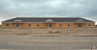
Property Record
3002 Pancheri Dr, Idaho Falls, ID 83402


NEARBY LISTINGS FOR SALE OR LEASE
Property Detail
3002 Pancheri Dr
Other Market Areas
Westridge Commercial Plaza Phase 2 Amd #
Idaho Falls, ID
UNIT 6, LOT 9, BLOCK 1, FIRST AMENDED PLAT OF WESTRIDGE COMMERCIAL PLAZA, WESTRIDGE COMMERCIAL PLAZA PHASE 2 FIRST AMENDED NE
RPA8562000006O
Bonneville
Industrialpark
Idaho
2025
9
2025
0.11 AC
971302
Idaho South Area
4,080 SF
DEMOGRAPHICS near 3002 Pancheri Dr
1 Mile
3 Mile
5 Mile
2024 Total Population
6,142
27,993
71,236
2029 Population
6,977
31,763
80,754
Pop Growth 2024-2029
+ 13.59%
+ 13.47%
+ 13.36%
Average Age
38
36
37
2024 Total Households
2,133
10,469
26,226
HH Growth 2024-2029
+ 13.50%
+ 13.27%
+ 13.19%
Median Household Inc
$84,664
$62,945
$66,895
Avg Household Size
2.80
2.60
2.60
2024 Avg HH Vehicles
2.00
2.00
2.00
Median Home Value
$324,262
$316,745
$321,831
Median Year Built
1992
1977
1978
Nearby Places
Map Layers
Map Styles
 Street
 Aerial
- Restaurants
- Banks
- Shops
- Fitness
- Groceries
PUBLIC TRANSPORTATION
AIRPORT
Idaho Falls Regional
DRIVE
WALK
Distance
Idaho Falls Regional
9 min
3.6 mi
Freight Ports
Port of Portland
DRIVE
WALK
Distance
Port of Portland
740 min
708.8 mi
SALE & LEASE HISTORY
LISTING DATE
SALE/LEASE

Sep 25, 2016
For Lease
Nearby Properties
Address
Land Use
TOTAL SIZE
Lot Size
Zoning
Address
Land Use
TOTAL SIZE
Lot Size
Zoning
57,420 SF
8.59 AC
Address
Land Use
TOTAL SIZE
Lot Size
Zoning
37,287 SF
9.46 AC
Address
Land Use
TOTAL SIZE
Lot Size
Zoning
136,343 SF
10 AC
Address
Land Use
TOTAL SIZE
Lot Size
Zoning
4,118 SF
25.18 AC
R2
Address
Land Use
TOTAL SIZE
Lot Size
Zoning
220,179 SF
22.20 AC
R2
Address
Land Use
TOTAL SIZE
Lot Size
Zoning
111,649 SF
8.60 AC
Address
Land Use
TOTAL SIZE
Lot Size
Zoning
108,128 SF
14.53 AC
Address
Land Use
TOTAL SIZE
Lot Size
Zoning
273,545 SF
15.89 AC
R2
Address
Land Use
TOTAL SIZE
Lot Size
Zoning
27,084 SF
3.69 AC
Address
Land Use
TOTAL SIZE
Lot Size
Zoning
89,263 SF
3.92 AC
Address
Land Use
TOTAL SIZE
Lot Size
Zoning
25,629 SF
14.42 AC
Address
Land Use
TOTAL SIZE
Lot Size
Zoning
61,715 SF
4.12 AC
Address
Land Use
TOTAL SIZE
Lot Size
Zoning
98,476 SF
0.66 AC
R2
Address
Land Use
TOTAL SIZE
Lot Size
Zoning
152,632 SF
7.49 AC
R2
Address
Land Use
TOTAL SIZE
Lot Size
Zoning
91,002 SF
2.70 AC
R2
Address
Land Use
TOTAL SIZE
Lot Size
Zoning
74,398 SF
1.87 AC
Address
Land Use
TOTAL SIZE
Lot Size
Zoning
33,086 SF
0.30 AC
Address
Land Use
TOTAL SIZE
Lot Size
Zoning
43,783 SF
2.20 AC
R2
Address
Land Use
TOTAL SIZE
Lot Size
Zoning
58,902 SF
2.17 AC
Address
Land Use
TOTAL SIZE
Lot Size
Zoning
37,223 SF
5.96 AC
R2
Address
Land Use
TOTAL SIZE
Lot Size
Zoning
35,235 SF
4.90 AC
Address
Land Use
TOTAL SIZE
Lot Size
Zoning
49,782 SF
1.96 AC
R2
Address
Land Use
TOTAL SIZE
Lot Size
Zoning
24,411 SF
4.87 AC
Address
Land Use
TOTAL SIZE
Lot Size
Zoning
13,826 SF
19.84 AC
Address
Land Use
TOTAL SIZE
Lot Size
Zoning
52,980 SF
2.63 AC
R2
Address
Land Use
TOTAL SIZE
Lot Size
Zoning
46,993 SF
6.18 AC
Address
Land Use
TOTAL SIZE
Lot Size
Zoning
39,776 SF
1.48 AC
Address
Land Use
TOTAL SIZE
Lot Size
Zoning
44,349 SF
2.05 AC
R2
Address
Land Use
TOTAL SIZE
Lot Size
Zoning
95,378 SF
8.39 AC
R2
Address
Land Use
TOTAL SIZE
Lot Size
Zoning
153,581 SF
6.01 AC
R2
The World's #1 Commercial Real Estate Marketplace
Connect with us
© 2026 CoStar Group
The information above has been obtained from sources believed reliable. While we do not doubt its accuracy we have not verified it and make no guarantee, warranty or representation about it. It is your responsibility to independently confirm its accuracy and completeness. Any projections, opinions, assumptions, or estimates used are for example only and do not represent the current or future performance of the property. The value of this transaction to you depends on tax and other factors which should be evaluated by your tax, financial, and legal advisors. You and your advisors should conduct a careful, independent investigation of the property to determine to your satisfaction the suitability of the property for your needs.