Property Record
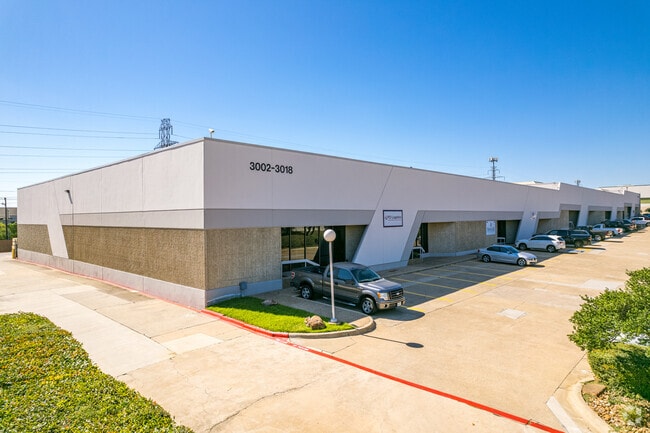
3002 Skyway Cir S, Irving, TX 75038


Current Lease Availabilities
NEARBY LISTINGS FOR SALE OR LEASE
Property Detail
3002 Skyway Cir S
32565200540000000
Walnut Hill Bus Pk Sec 9 6Th Inst
Officebuilding
WALNUT HILL BUS PK SEC 9 6TH INST 6TH INST BLK D ACS 3.9987 INT202500047448 DD03062025 CO-DC 5652005400000 1CI56520054
X
Dallas
48113C0305L
Texas
2024
4 AC
2025
E DFW Air/Las Colinas
014158
Dallas/Ft Worth
65,450 SF
Dallas-Fort Worth-Arlington, TX
DEMOGRAPHICS near 3002 Skyway Cir S
1 Mile
3 Mile
5 Mile
2024 Total Population
18,387
111,316
238,238
2029 Population
18,216
109,901
237,664
Pop Growth 2024-2029
(0.93%)
(1.27%)
(0.24%)
Average Age
33
34
35
2024 Total Households
7,461
43,023
91,859
HH Growth 2024-2029
(1.18%)
(1.42%)
(0.38%)
Median Household Inc
$59,503
$69,605
$71,337
Avg Household Size
2.40
2.50
2.50
2024 Avg HH Vehicles
2.00
2.00
2.00
Median Home Value
$309,004
$269,789
$276,002
Median Year Built
1984
1984
1987
Nearby Places
Map Layers
Map Styles
 Street
 Aerial
- Restaurants
- Banks
- Shops
- Fitness
- Groceries
PUBLIC TRANSPORTATION
COMMUTER RAIL
West Irving (TRINITY RAILWAY - Dallas Area Rapid Transit (DART), Trinity Railway Express - Dallas Area Rapid Transit (DART))
DRIVE
WALK
Distance
West Irving (TRINITY RAILWAY - Dallas Area Rapid Transit (DART), Trinity Railway Express - Dallas Area Rapid Transit (DART))
11 min
6.4 mi
East Tex Yard Limit (TRINITY RAILWAY - Dallas Area Rapid Transit (DART))
DRIVE
WALK
Distance
East Tex Yard Limit (TRINITY RAILWAY - Dallas Area Rapid Transit (DART))
12 min
7.8 mi
AIRPORT
Dallas-Fort Worth International
DRIVE
WALK
Distance
Dallas-Fort Worth International
14 min
7.2 mi
Dallas Love Field
DRIVE
WALK
Distance
Dallas Love Field
23 min
12.8 mi
Freight Ports
Port of Shreveport
DRIVE
WALK
Distance
Port of Shreveport
231 min
214.3 mi
Nearby Properties
Address
Land Use
TOTAL SIZE
Lot Size
Zoning
Address
Land Use
TOTAL SIZE
Lot Size
Zoning
12,780,691 SF
0.08 AC
Z392
Address
Land Use
TOTAL SIZE
Lot Size
Zoning
1,066,464 SF
4.10 AC
Z392
Address
Land Use
TOTAL SIZE
Lot Size
Zoning
2,496,382 SF
256.13 AC
Z392
Address
Land Use
TOTAL SIZE
Lot Size
Zoning
962,320 SF
23.81 AC
Z198
Address
Land Use
TOTAL SIZE
Lot Size
Zoning
1,520,000 SF
34.76 AC
Z243
Address
Land Use
TOTAL SIZE
Lot Size
Zoning
850,390 SF
16.12 AC
Address
Land Use
TOTAL SIZE
Lot Size
Zoning
565,728 SF
21.07 AC
Address
Land Use
TOTAL SIZE
Lot Size
Zoning
346,000 SF
15.52 AC
Z198
Address
Land Use
TOTAL SIZE
Lot Size
Zoning
1,673,367 SF
17.29 AC
Z243
Address
Land Use
TOTAL SIZE
Lot Size
Zoning
1,763,184 SF
11.25 AC
Z393
Address
Land Use
TOTAL SIZE
Lot Size
Zoning
379,000 SF
9.81 AC
Z243
Address
Land Use
TOTAL SIZE
Lot Size
Zoning
674,817 SF
15.35 AC
Z84
Address
Land Use
TOTAL SIZE
Lot Size
Zoning
631,947 SF
11.95 AC
Z393
Address
Land Use
TOTAL SIZE
Lot Size
Zoning
689,004 SF
25.23 AC
Z243
Address
Land Use
TOTAL SIZE
Lot Size
Zoning
735,258 SF
4.83 AC
Z392
Address
Land Use
TOTAL SIZE
Lot Size
Zoning
1,144,971 SF
19.43 AC
Z84
Address
Land Use
TOTAL SIZE
Lot Size
Zoning
729,870 SF
24.42 AC
Z393
Address
Land Use
TOTAL SIZE
Lot Size
Zoning
464,996 SF
18.43 AC
SP2
Address
Land Use
TOTAL SIZE
Lot Size
Zoning
671,349 SF
5.31 AC
Z243
Address
Land Use
TOTAL SIZE
Lot Size
Zoning
724,643 SF
5.15 AC
Z243
Address
Land Use
TOTAL SIZE
Lot Size
Zoning
347,008 SF
9.54 AC
Z57
Address
Land Use
TOTAL SIZE
Lot Size
Zoning
1,219,380 SF
16.01 AC
Z243
Address
Land Use
TOTAL SIZE
Lot Size
Zoning
457,322 SF
22.98 AC
Z243
Address
Land Use
TOTAL SIZE
Lot Size
Zoning
543,965 SF
8.02 AC
Z323
Address
Land Use
TOTAL SIZE
Lot Size
Zoning
717,650 SF
28.32 AC
Z243
Address
Land Use
TOTAL SIZE
Lot Size
Zoning
588,626 SF
6.55 AC
Z84
Address
Land Use
TOTAL SIZE
Lot Size
Zoning
482,696 SF
5.39 AC
Z86
Address
Land Use
TOTAL SIZE
Lot Size
Zoning
505,823 SF
29.64 AC
Z113
Address
Land Use
TOTAL SIZE
Lot Size
Zoning
616,333 SF
6.32 AC
Z393
Address
Land Use
TOTAL SIZE
Lot Size
Zoning
1,793,119 SF
85 AC
The World's #1 Commercial Real Estate Marketplace
Connect with us
© 2025 CoStar Group
The information above has been obtained from sources believed reliable. While we do not doubt its accuracy we have not verified it and make no guarantee, warranty or representation about it. It is your responsibility to independently confirm its accuracy and completeness. Any projections, opinions, assumptions, or estimates used are for example only and do not represent the current or future performance of the property. The value of this transaction to you depends on tax and other factors which should be evaluated by your tax, financial, and legal advisors. You and your advisors should conduct a careful, independent investigation of the property to determine to your satisfaction the suitability of the property for your needs.