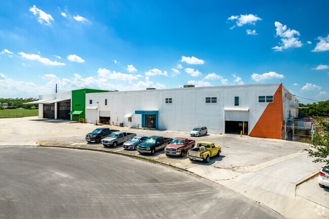
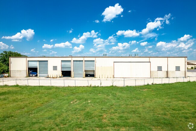
Property Record
3003 Aniol St, San Antonio, TX 78219

Current Lease Availabilities
Property Detail
3003 Aniol St
San Antonio-New Braunfels, TX
NCB 10127 (COLISEUM INDUSTRIAL PARK SUBD), BLK A, LOT 20 2020-MERGE PER CR#47048NEW ACCT FOR 2007 - PLAT 9569/12
10127-001-0200
Bexar
Warehouse
Texas
B and X Area of moderate flood hazard, usually the area between the limits of the 100-year and 500-year floods.
20
2024
7.75 AC
2025
Northeast
130800
San Antonio
87,357 SF
NEARBY LISTINGS FOR SALE OR LEASE
DEMOGRAPHICS near 3003 Aniol St
1 mile
3 mile
5 mile
2025 Total Population
7,000
91,413
278,531
2030 Population
7,449
98,038
295,623
Pop Growth 2025-2030
+ 6.41%
+ 7.25%
+ 6.14%
Average Age
35
36
38
2025 Total Households
2,468
33,071
105,626
HH Growth 2025-2030
+ 6.44%
+ 7.63%
+ 6.46%
Median Household Inc
$29,015
$50,153
$55,889
Avg Household Size
2.80
2.50
2.40
2025 Avg HH Vehicles
1.00
2.00
2.00
Median Home Value
$141,666
$211,669
$232,226
Median Year Built
1968
1968
1965
Nearby Places
Map Layers
Map Styles
 Street
 Aerial
Layers
 Traffic
 Biking
Places
Listings with unknown addresses are not visible on the map
- Restaurants
- Banks
- Shops
- Fitness
- Groceries
PUBLIC TRANSPORTATION
AIRPORT
San Antonio International
Drive
Walk
Distance
San Antonio International
13 min
10.3 mi
Freight Ports
Calhoun Port
Drive
Walk
Distance
Calhoun Port
1 min
125.2 mi
Nearby Properties
Address
Land Use
TOTAL SIZE
Lot Size
Zoning
Address
Land Use
TOTAL SIZE
Lot Size
Zoning
2,544.56 AC
Address
Land Use
TOTAL SIZE
Lot Size
Zoning
26.51 AC
Address
Land Use
TOTAL SIZE
Lot Size
Zoning
443,000 SF
4.16 AC
Address
Land Use
TOTAL SIZE
Lot Size
Zoning
738,650 SF
2.93 AC
Address
Land Use
TOTAL SIZE
Lot Size
Zoning
1,049,861 SF
1.50 AC
Address
Land Use
TOTAL SIZE
Lot Size
Zoning
339,590 SF
3.12 AC
Address
Land Use
TOTAL SIZE
Lot Size
Zoning
922,468 SF
10.78 AC
Address
Land Use
TOTAL SIZE
Lot Size
Zoning
8.10 AC
Address
Land Use
TOTAL SIZE
Lot Size
Zoning
5,106 SF
2.30 AC
Address
Land Use
TOTAL SIZE
Lot Size
Zoning
43,834 SF
3.11 AC
Address
Land Use
TOTAL SIZE
Lot Size
Zoning
178,534 SF
1.32 AC
Address
Land Use
TOTAL SIZE
Lot Size
Zoning
103,425 SF
4.76 AC
Address
Land Use
TOTAL SIZE
Lot Size
Zoning
254,908 SF
1.92 AC
Address
Land Use
TOTAL SIZE
Lot Size
Zoning
11,915 SF
4.06 AC
Address
Land Use
TOTAL SIZE
Lot Size
Zoning
173,422 SF
5.85 AC
Address
Land Use
TOTAL SIZE
Lot Size
Zoning
221,865 SF
3.12 AC
Address
Land Use
TOTAL SIZE
Lot Size
Zoning
481,589 SF
5.29 AC
Address
Land Use
TOTAL SIZE
Lot Size
Zoning
303,199 SF
9.88 AC
Address
Land Use
TOTAL SIZE
Lot Size
Zoning
161,652 SF
1.79 AC
Address
Land Use
TOTAL SIZE
Lot Size
Zoning
4,075 SF
2.80 AC
Address
Land Use
TOTAL SIZE
Lot Size
Zoning
9,390 SF
3.71 AC
Address
Land Use
TOTAL SIZE
Lot Size
Zoning
219,419 SF
2.59 AC
Address
Land Use
TOTAL SIZE
Lot Size
Zoning
352,920 SF
2.48 AC
Address
Land Use
TOTAL SIZE
Lot Size
Zoning
331,500 SF
1.82 AC
Address
Land Use
TOTAL SIZE
Lot Size
Zoning
359,459 SF
15.81 AC
Address
Land Use
TOTAL SIZE
Lot Size
Zoning
202,609 SF
3.25 AC
Address
Land Use
TOTAL SIZE
Lot Size
Zoning
71,253 SF
25.52 AC
Address
Land Use
TOTAL SIZE
Lot Size
Zoning
32,093 SF
7 AC
Address
Land Use
TOTAL SIZE
Lot Size
Zoning
2,833 SF
2.25 AC
Address
Land Use
TOTAL SIZE
Lot Size
Zoning
147,381 SF
0.92 AC
The World's #1 Commercial Real Estate Marketplace
Connect with us
© 2026 CoStar Group
The information above has been obtained from sources believed reliable. While we do not doubt its accuracy we have not verified it and make no guarantee, warranty or representation about it. It is your responsibility to independently confirm its accuracy and completeness. Any projections, opinions, assumptions, or estimates used are for example only and do not represent the current or future performance of the property. The value of this transaction to you depends on tax and other factors which should be evaluated by your tax, financial, and legal advisors. You and your advisors should conduct a careful, independent investigation of the property to determine to your satisfaction the suitability of the property for your needs.