Property Record
3003 Ne 3Rd Ave, Camas, WA 98607
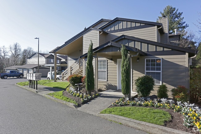

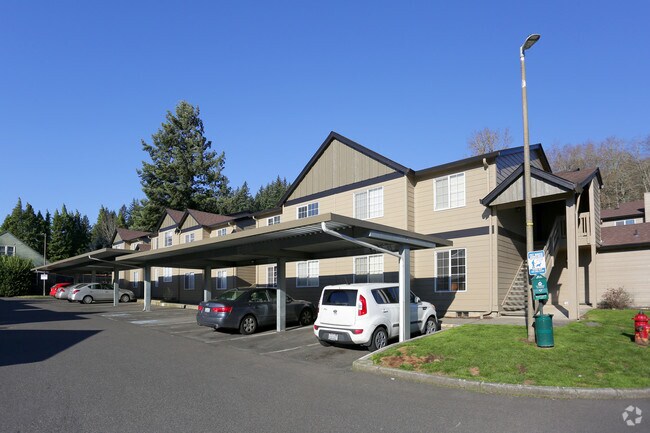
Property Detail
3003 Ne 3Rd Ave
073134-049
#49 DAVID C PARKER DLC 3.30A M/L FOR ASSESSOR USE ONLY E1/2 OF E1/2 OF FOLL BEG ON N BK OF WASHOUGAL RIVER WHERE DIV LI BET E & W1/4 OF PARKER DLC CROSSES RIVER TH N 7 DG 31 MIN E 15.50 CHS TO NW COR OF E1/2 SD DLC TH S 73DG 45 MIN E 13 CHS TH S 7 DG
Multifamilydwelling
Clark
MF-18
Washington
B and X Area of moderate flood hazard, usually the area between the limits of the 100-year and 500-year floods.
3.30 AC
2025
Outlying Vancouver
2025
Portland
040605
Portland-Vancouver-Hillsboro, OR-WA
64,400 SF
NEARBY LISTINGS FOR SALE OR LEASE
-
-
View all Camas listings for sale on LoopNet.com
DEMOGRAPHICS near 3003 Ne 3Rd Ave
1 mile
3 mile
5 mile
2025 Total Population
8,100
36,426
86,621
2030 Population
8,440
37,780
88,374
Pop Growth 2025-2030
+ 4.20%
+ 3.72%
+ 2.02%
Average Age
40
40
40
2025 Total Households
3,117
13,066
30,685
HH Growth 2025-2030
+ 4.30%
+ 3.86%
+ 2.07%
Median Household Inc
$92,017
$117,023
$104,995
Avg Household Size
2.60
2.80
2.80
2025 Avg HH Vehicles
2.00
2.00
2.00
Median Home Value
$671,137
$677,174
$592,348
Median Year Built
1997
1996
1995
Nearby Places
Map Layers
Map Styles
 Street
 Aerial
Transit
 Traffic
 Biking
Places
Listings with unknown addresses are not visible on the map
- Restaurants
- Banks
- Shops
- Fitness
- Groceries
PUBLIC TRANSPORTATION
AIRPORT
Portland International
Drive
Walk
Distance
Portland International
25 min
14.4 mi
Freight Ports
Port of Portland
Drive
Walk
Distance
Port of Portland
36 min
23.3 mi
Nearby Properties
Address
Land Use
TOTAL SIZE
Lot Size
Zoning
Address
Land Use
TOTAL SIZE
Lot Size
Zoning
1,500,000 SF
189.27 AC
HI
Address
Land Use
TOTAL SIZE
Lot Size
Zoning
Address
Land Use
TOTAL SIZE
Lot Size
Zoning
478,472 SF
77.86 AC
GI
Address
Land Use
TOTAL SIZE
Lot Size
Zoning
255,683 SF
32.06 AC
R-7.5
Address
Land Use
TOTAL SIZE
Lot Size
Zoning
857,470 SF
73.72 AC
GI
Address
Land Use
TOTAL SIZE
Lot Size
Zoning
262,320 SF
25.24 AC
IP
Address
Land Use
TOTAL SIZE
Lot Size
Zoning
14,059 SF
12.83 AC
GI
Address
Land Use
TOTAL SIZE
Lot Size
Zoning
224,500 SF
12.30 AC
R-7.5
Address
Land Use
TOTAL SIZE
Lot Size
Zoning
114,696 SF
2.29 AC
MF-18
Address
Land Use
TOTAL SIZE
Lot Size
Zoning
142,571 SF
1.73 AC
TC-C
Address
Land Use
TOTAL SIZE
Lot Size
Zoning
Address
Land Use
TOTAL SIZE
Lot Size
Zoning
349,080 SF
18.69 AC
GI
Address
Land Use
TOTAL SIZE
Lot Size
Zoning
65,604 SF
11.35 AC
R-7.5
Address
Land Use
TOTAL SIZE
Lot Size
Zoning
Address
Land Use
TOTAL SIZE
Lot Size
Zoning
4,490 SF
75.54 AC
GI
Address
Land Use
TOTAL SIZE
Lot Size
Zoning
85,150 SF
16.32 AC
R-7.5
Address
Land Use
TOTAL SIZE
Lot Size
Zoning
83,139 SF
7.36 AC
HI
Address
Land Use
TOTAL SIZE
Lot Size
Zoning
98,577 SF
7.28 AC
GI
Address
Land Use
TOTAL SIZE
Lot Size
Zoning
256,888 SF
18.91 AC
TC-C
Address
Land Use
TOTAL SIZE
Lot Size
Zoning
52,631 SF
3.04 AC
MF-10
Address
Land Use
TOTAL SIZE
Lot Size
Zoning
44.82 AC
SU
Address
Land Use
TOTAL SIZE
Lot Size
Zoning
108,108 SF
5.35 AC
IP
Address
Land Use
TOTAL SIZE
Lot Size
Zoning
10,000 SF
13.63 AC
R-7.5
Address
Land Use
TOTAL SIZE
Lot Size
Zoning
75,360 SF
4.46 AC
RC
Address
Land Use
TOTAL SIZE
Lot Size
Zoning
51,600 SF
2.35 AC
AR-16
Address
Land Use
TOTAL SIZE
Lot Size
Zoning
68,130 SF
9.19 AC
R-7.5
Address
Land Use
TOTAL SIZE
Lot Size
Zoning
44.92 AC
OS
Address
Land Use
TOTAL SIZE
Lot Size
Zoning
18,368 SF
21.40 AC
GI
The World's #1 Commercial Real Estate Marketplace
Connect with us
© 2026 CoStar Group
The information above has been obtained from sources believed reliable. While we do not doubt its accuracy we have not verified it and make no guarantee, warranty or representation about it. It is your responsibility to independently confirm its accuracy and completeness. Any projections, opinions, assumptions, or estimates used are for example only and do not represent the current or future performance of the property. The value of this transaction to you depends on tax and other factors which should be evaluated by your tax, financial, and legal advisors. You and your advisors should conduct a careful, independent investigation of the property to determine to your satisfaction the suitability of the property for your needs.