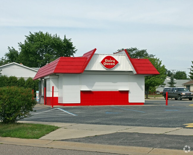
Property Record
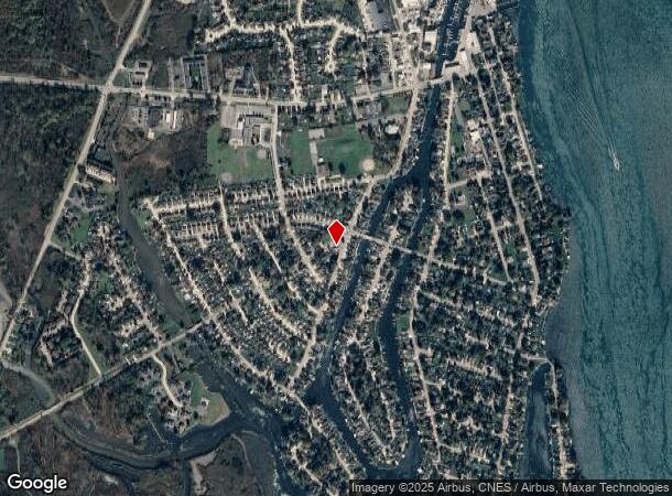
30030 S Gibraltar Rd, Gibraltar, MI 48173

NEARBY LISTINGS FOR SALE OR LEASE
Property Detail
30030 S Gibraltar Rd
Detroit-Warren-Dearborn, MI
Halls Gibraltar No 1
36-017-01-1437-301
01D1437 1438 1439 T5S LOTS 1437, 1438 AND 1439 ALSO NLY 1/2 ADJ VAC ALLEY HALLS GIBRALTAR SUB NO. 1 PC 54,355 T5S R10E L56
Restaurantdrivein
Wayne
X
Michigan
26163C0529F
1437
2023
0.27 AC
2025
Downriver South
597000
Detroit
612 SF
DEMOGRAPHICS near 30030 S Gibraltar Rd
1 Mile
3 Mile
5 Mile
2024 Total Population
3,862
24,149
68,513
2029 Population
3,712
23,139
65,826
Pop Growth 2024-2029
(3.88%)
(4.18%)
(3.92%)
Average Age
43
43
43
2024 Total Households
1,651
9,876
28,235
HH Growth 2024-2029
(3.94%)
(4.21%)
(3.95%)
Median Household Inc
$83,928
$82,479
$80,725
Avg Household Size
2.30
2.40
2.40
2024 Avg HH Vehicles
2.00
2.00
2.00
Median Home Value
$227,489
$217,395
$216,026
Median Year Built
1970
1976
1973
Nearby Places
Map Layers
Map Styles
 Street
 Aerial
- Restaurants
- Banks
- Shops
- Fitness
- Groceries
PUBLIC TRANSPORTATION
AIRPORT
Detroit Metro Wayne County
DRIVE
WALK
Distance
Detroit Metro Wayne County
27 min
17.4 mi
Windsor International
DRIVE
WALK
Distance
Windsor International
51 min
33.0 mi
Freight Ports
Port of Toledo
DRIVE
WALK
Distance
Port of Toledo
55 min
41.6 mi
Nearby Properties
Address
Land Use
TOTAL SIZE
Lot Size
Zoning
Address
Land Use
TOTAL SIZE
Lot Size
Zoning
3,189,689 SF
228.88 AC
Address
Land Use
TOTAL SIZE
Lot Size
Zoning
155,600 SF
83.84 AC
R1
Address
Land Use
TOTAL SIZE
Lot Size
Zoning
1,021,918 SF
163.58 AC
Address
Land Use
TOTAL SIZE
Lot Size
Zoning
178,682 SF
19.23 AC
Address
Land Use
TOTAL SIZE
Lot Size
Zoning
92,397 SF
12.63 AC
PUD
Address
Land Use
TOTAL SIZE
Lot Size
Zoning
169,192 SF
11.90 AC
R1
Address
Land Use
TOTAL SIZE
Lot Size
Zoning
59,427 SF
5.50 AC
Address
Land Use
TOTAL SIZE
Lot Size
Zoning
68,409 SF
64.56 AC
Address
Land Use
TOTAL SIZE
Lot Size
Zoning
95,650 SF
73.78 AC
Address
Land Use
TOTAL SIZE
Lot Size
Zoning
48,760 SF
4.86 AC
Address
Land Use
TOTAL SIZE
Lot Size
Zoning
18,678 SF
3.10 AC
R1-ONE
Address
Land Use
TOTAL SIZE
Lot Size
Zoning
2,816 SF
86.70 AC
RESIDE
Address
Land Use
TOTAL SIZE
Lot Size
Zoning
146,300 SF
25.84 AC
Address
Land Use
TOTAL SIZE
Lot Size
Zoning
101,861 SF
15.33 AC
B-2
Address
Land Use
TOTAL SIZE
Lot Size
Zoning
62,039 SF
Address
Land Use
TOTAL SIZE
Lot Size
Zoning
164,567 SF
13.78 AC
RESIDE
Address
Land Use
TOTAL SIZE
Lot Size
Zoning
551,184 SF
RESIDE
Address
Land Use
TOTAL SIZE
Lot Size
Zoning
124,602 SF
10.20 AC
Address
Land Use
TOTAL SIZE
Lot Size
Zoning
52,085 SF
5 AC
RM-1
Address
Land Use
TOTAL SIZE
Lot Size
Zoning
551,184 SF
42.34 AC
RESIDE
Address
Land Use
TOTAL SIZE
Lot Size
Zoning
40,136 SF
42.97 AC
R-1-D
Address
Land Use
TOTAL SIZE
Lot Size
Zoning
65,435 SF
24.77 AC
RESIDE
Address
Land Use
TOTAL SIZE
Lot Size
Zoning
74,095 SF
5.94 AC
Address
Land Use
TOTAL SIZE
Lot Size
Zoning
16,980 SF
6.11 AC
RESIDE
Address
Land Use
TOTAL SIZE
Lot Size
Zoning
3,500 SF
106.18 AC
R-1-D
Address
Land Use
TOTAL SIZE
Lot Size
Zoning
66,105 SF
7.76 AC
RESIDE
Address
Land Use
TOTAL SIZE
Lot Size
Zoning
6,072 SF
9.49 AC
Address
Land Use
TOTAL SIZE
Lot Size
Zoning
93,192 SF
18.72 AC
Address
Land Use
TOTAL SIZE
Lot Size
Zoning
19,908 SF
2.59 AC
RESIDE
Address
Land Use
TOTAL SIZE
Lot Size
Zoning
44,550 SF
4.23 AC
The World's #1 Commercial Real Estate Marketplace
Connect with us
© 2025 CoStar Group
The information above has been obtained from sources believed reliable. While we do not doubt its accuracy we have not verified it and make no guarantee, warranty or representation about it. It is your responsibility to independently confirm its accuracy and completeness. Any projections, opinions, assumptions, or estimates used are for example only and do not represent the current or future performance of the property. The value of this transaction to you depends on tax and other factors which should be evaluated by your tax, financial, and legal advisors. You and your advisors should conduct a careful, independent investigation of the property to determine to your satisfaction the suitability of the property for your needs.