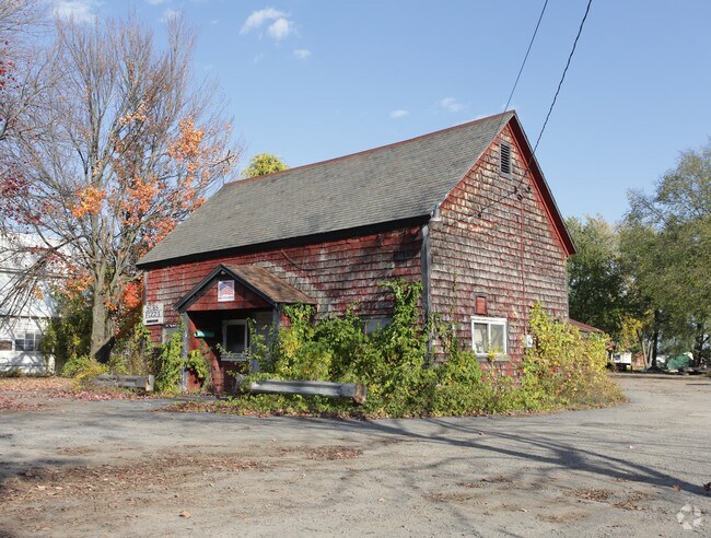
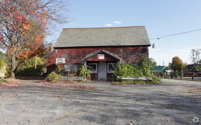
Property Record
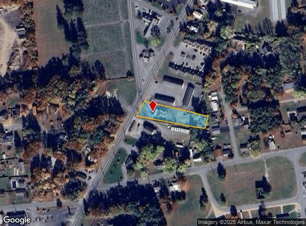
3004 State Route 4, Hudson Falls, NY 12839
NEARBY LISTINGS FOR SALE OR LEASE
-
-
View all Hudson Falls listings for sale on LoopNet.com
Property Detail
3004 State Route 4
Glens Falls, NY
Washington
534489-146-018-0009-024-000-0000
New York
Warehouse
24.000
2025
0.82 AC
2024
Washington County
080301
Albany/Schenectady/Troy
2,095 SF
DEMOGRAPHICS near 3004 State Route 4
1 Mile
3 Mile
5 Mile
2024 Total Population
5,613
16,873
47,961
2029 Population
5,530
16,681
47,642
Pop Growth 2024-2029
(1.48%)
(1.14%)
(0.67%)
Average Age
41
41
42
2024 Total Households
2,438
7,169
21,009
HH Growth 2024-2029
(1.56%)
(1.20%)
(0.73%)
Median Household Inc
$59,674
$61,107
$63,250
Avg Household Size
2.20
2.30
2.20
2024 Avg HH Vehicles
1.00
2.00
2.00
Median Home Value
$152,701
$157,564
$175,509
Median Year Built
1964
1956
1959
Nearby Places
- Restaurants
- Banks
- Shops
- Fitness
- Groceries
PUBLIC TRANSPORTATION
COMMUTER RAIL
DRIVE
WALK
Distance
10 min
3.8 mi
Freight Ports
Albany, NY Port
DRIVE
WALK
Distance
Albany, NY Port
80 min
56.9 mi
Nearby Properties
Address
Land Use
TOTAL SIZE
Lot Size
Zoning
Address
Land Use
TOTAL SIZE
Lot Size
Zoning
16.34 AC
M1
Address
Land Use
TOTAL SIZE
Lot Size
Zoning
116,696 SF
23.70 AC
04 - FARM
Address
Land Use
TOTAL SIZE
Lot Size
Zoning
35.53 AC
HI
Address
Land Use
TOTAL SIZE
Lot Size
Zoning
9,216 SF
32.20 AC
UR
Address
Land Use
TOTAL SIZE
Lot Size
Zoning
82,922 SF
8.03 AC
I
Address
Land Use
TOTAL SIZE
Lot Size
Zoning
5,680 SF
39.79 AC
UR
Address
Land Use
TOTAL SIZE
Lot Size
Zoning
113.40 AC
04 - FARM
Address
Land Use
TOTAL SIZE
Lot Size
Zoning
5,440 SF
510.06 AC
CLI
Address
Land Use
TOTAL SIZE
Lot Size
Zoning
12,337 SF
26.95 AC
HI
Address
Land Use
TOTAL SIZE
Lot Size
Zoning
7,823 SF
27.33 AC
LDR25
Address
Land Use
TOTAL SIZE
Lot Size
Zoning
6,549 SF
17.26 AC
M1
Address
Land Use
TOTAL SIZE
Lot Size
Zoning
156,550 SF
33.27 AC
CI
Address
Land Use
TOTAL SIZE
Lot Size
Zoning
7,788 SF
25.34 AC
LDR25
Address
Land Use
TOTAL SIZE
Lot Size
Zoning
20,250 SF
46.97 AC
HI
Address
Land Use
TOTAL SIZE
Lot Size
Zoning
18,133 SF
29.71 AC
LDR25
Address
Land Use
TOTAL SIZE
Lot Size
Zoning
53,216 SF
14.20 AC
CLI
Address
Land Use
TOTAL SIZE
Lot Size
Zoning
3,000 SF
14.95 AC
M1
Address
Land Use
TOTAL SIZE
Lot Size
Zoning
176,238 SF
28.98 AC
CLI
Address
Land Use
TOTAL SIZE
Lot Size
Zoning
134,998 SF
20.10 AC
05 - COMME
Address
Land Use
TOTAL SIZE
Lot Size
Zoning
150,882 SF
8 AC
LI
Address
Land Use
TOTAL SIZE
Lot Size
Zoning
119,455 SF
66.60 AC
LDR25
Address
Land Use
TOTAL SIZE
Lot Size
Zoning
42,156 SF
5.93 AC
05 - COMME
Address
Land Use
TOTAL SIZE
Lot Size
Zoning
141,480 SF
29.05 AC
RA
Address
Land Use
TOTAL SIZE
Lot Size
Zoning
56,884 SF
8.73 AC
R2
Address
Land Use
TOTAL SIZE
Lot Size
Zoning
60,000 SF
15.96 AC
CLI
Address
Land Use
TOTAL SIZE
Lot Size
Zoning
41,280 SF
50.96 AC
M1
Address
Land Use
TOTAL SIZE
Lot Size
Zoning
36,657 SF
5.12 AC
C2
Address
Land Use
TOTAL SIZE
Lot Size
Zoning
106,209 SF
6.22 AC
M1
Address
Land Use
TOTAL SIZE
Lot Size
Zoning
19,317 SF
12.97 AC
CLI
Address
Land Use
TOTAL SIZE
Lot Size
Zoning
103,300 SF
26.61 AC
LI
The World's #1 Commercial Real Estate Marketplace
Connect with us
© 2025 CoStar Group
The information above has been obtained from sources believed reliable. While we do not doubt its accuracy we have not verified it and make no guarantee, warranty or representation about it. It is your responsibility to independently confirm its accuracy and completeness. Any projections, opinions, assumptions, or estimates used are for example only and do not represent the current or future performance of the property. The value of this transaction to you depends on tax and other factors which should be evaluated by your tax, financial, and legal advisors. You and your advisors should conduct a careful, independent investigation of the property to determine to your satisfaction the suitability of the property for your needs.