Property Record
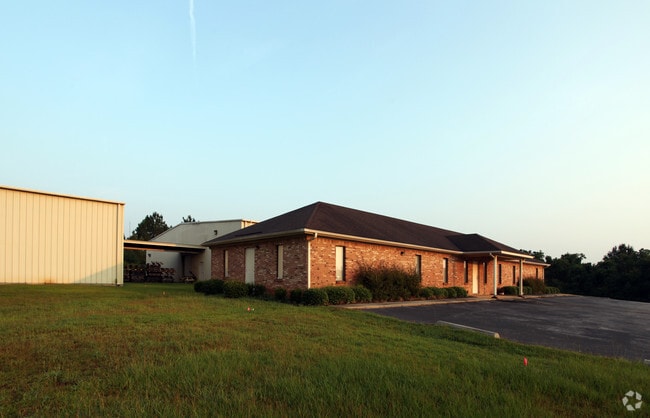
30075 County Road 49, Loxley, AL 36551


Property Detail
30075 County Road 49
33-08-27-0-000-001.006
7.1 AC(C) FM SE COR OF SW1/4 OF SEC 27 RUN W 29.9', TH N 30' TO POB CONT N ALG W/L OF HWY 49 550', TH W 594', TH SE 555.9', T
Officebuilding
BALDWIN
B and X Area of moderate flood hazard, usually the area between the limits of the 100-year and 500-year floods.
Alabama
2025
7 AC
2025
Baldwin County
010400
Mobile
3,340 SF
Daphne-Fairhope-Foley, AL
NEARBY LISTINGS FOR SALE OR LEASE
-
-
View all Loxley listings for sale on LoopNet.com
DEMOGRAPHICS near 30075 County Road 49
1 mile
3 mile
5 mile
2025 Total Population
29
3,438
15,005
2030 Population
32
3,744
16,271
Pop Growth 2025-2030
+ 10.34%
+ 8.90%
+ 8.44%
Average Age
40
38
38
2025 Total Households
12
1,270
5,381
HH Growth 2025-2030
+ 8.33%
+ 9.06%
+ 8.59%
Median Household Inc
$63,750
$62,808
$69,385
Avg Household Size
2.50
2.60
2.70
2025 Avg HH Vehicles
3.00
2.00
2.00
Median Home Value
$250,000
$272,026
$273,516
Median Year Built
1992
2002
2003
Nearby Places
Map Layers
Map Styles
 Street
 Aerial
Layers
 Traffic
 Biking
Places
Listings with unknown addresses are not visible on the map
- Restaurants
- Banks
- Shops
- Fitness
- Groceries
PUBLIC TRANSPORTATION
AIRPORT
Mobile International
Drive
Walk
Distance
Mobile International
31 min
22.8 mi
Mobile Regional
Drive
Walk
Distance
Mobile Regional
53 min
36.5 mi
Freight Ports
Port of Mobile
Drive
Walk
Distance
Port of Mobile
25 min
19.4 mi
Nearby Properties
Address
Land Use
TOTAL SIZE
Lot Size
Zoning
Address
Land Use
TOTAL SIZE
Lot Size
Zoning
583,381 SF
147 AC
Address
Land Use
TOTAL SIZE
Lot Size
Zoning
827,037 SF
106 AC
Address
Land Use
TOTAL SIZE
Lot Size
Zoning
234,545 SF
12.20 AC
Address
Land Use
TOTAL SIZE
Lot Size
Zoning
125,294 SF
7 AC
Address
Land Use
TOTAL SIZE
Lot Size
Zoning
136,943 SF
6.60 AC
Address
Land Use
TOTAL SIZE
Lot Size
Zoning
Address
Land Use
TOTAL SIZE
Lot Size
Zoning
66,448 SF
8 AC
Address
Land Use
TOTAL SIZE
Lot Size
Zoning
81,447 SF
6.30 AC
Address
Land Use
TOTAL SIZE
Lot Size
Zoning
180,333 SF
7.60 AC
Address
Land Use
TOTAL SIZE
Lot Size
Zoning
144,122 SF
7.60 AC
Address
Land Use
TOTAL SIZE
Lot Size
Zoning
146,751 SF
7.10 AC
Address
Land Use
TOTAL SIZE
Lot Size
Zoning
144,111 SF
6.90 AC
Address
Land Use
TOTAL SIZE
Lot Size
Zoning
163,200 SF
7.40 AC
Address
Land Use
TOTAL SIZE
Lot Size
Zoning
174,174 SF
7 AC
Address
Land Use
TOTAL SIZE
Lot Size
Zoning
48,343 SF
3 AC
Address
Land Use
TOTAL SIZE
Lot Size
Zoning
4,613 SF
6.40 AC
Address
Land Use
TOTAL SIZE
Lot Size
Zoning
39,082 SF
1.67 AC
Address
Land Use
TOTAL SIZE
Lot Size
Zoning
6,148 SF
1.12 AC
Address
Land Use
TOTAL SIZE
Lot Size
Zoning
8,830 SF
4.40 AC
Address
Land Use
TOTAL SIZE
Lot Size
Zoning
42,423 SF
2.95 AC
Address
Land Use
TOTAL SIZE
Lot Size
Zoning
24,920 SF
5.10 AC
Address
Land Use
TOTAL SIZE
Lot Size
Zoning
20,000 SF
4.60 AC
Address
Land Use
TOTAL SIZE
Lot Size
Zoning
17,000 SF
6.90 AC
Address
Land Use
TOTAL SIZE
Lot Size
Zoning
73,949 SF
3 AC
Address
Land Use
TOTAL SIZE
Lot Size
Zoning
17,021 SF
0.81 AC
Address
Land Use
TOTAL SIZE
Lot Size
Zoning
5,334 SF
2.51 AC
Address
Land Use
TOTAL SIZE
Lot Size
Zoning
18,053 SF
4 AC
Address
Land Use
TOTAL SIZE
Lot Size
Zoning
24,640 SF
2.20 AC
Address
Land Use
TOTAL SIZE
Lot Size
Zoning
25,025 SF
2.40 AC
Address
Land Use
TOTAL SIZE
Lot Size
Zoning
10,007 SF
1.14 AC
The World's #1 Commercial Real Estate Marketplace
Connect with us
© 2026 CoStar Group
The information above has been obtained from sources believed reliable. While we do not doubt its accuracy we have not verified it and make no guarantee, warranty or representation about it. It is your responsibility to independently confirm its accuracy and completeness. Any projections, opinions, assumptions, or estimates used are for example only and do not represent the current or future performance of the property. The value of this transaction to you depends on tax and other factors which should be evaluated by your tax, financial, and legal advisors. You and your advisors should conduct a careful, independent investigation of the property to determine to your satisfaction the suitability of the property for your needs.