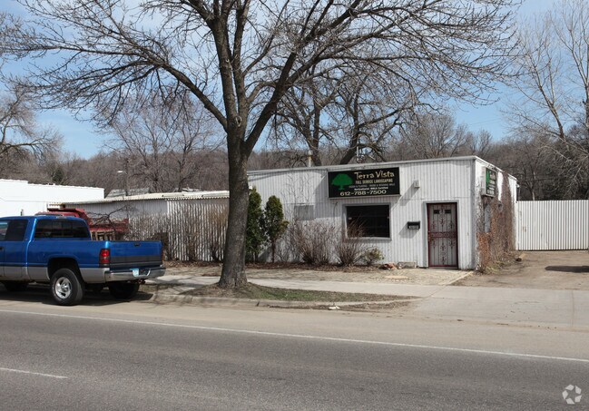
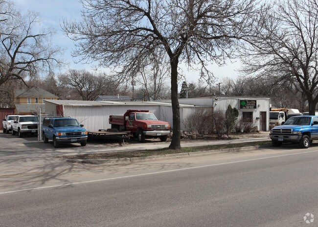
Property Record
3009 Central Ave Ne, Minneapolis, MN 55418

NEARBY LISTINGS FOR SALE OR LEASE
Property Detail
3009 Central Ave Ne
Minneapolis-St. Paul-Bloomington, MN-WI
Chute Bros 1St Addn To City Of Mpls
01-029-24-33-0088
LOT 018 BLOCK 012 A CHUTE BROS 1ST ADDN TO CITY OF MPLS 40.00 X 116.90
Commercialnec
Hennepin
X
Minnesota
27053C0240F
18
2024
0.11 AC
2024
Minneapolis
000601
Minneapolis/St Paul
1,040 SF
DEMOGRAPHICS near 3009 Central Ave Ne
1 Mile
3 Mile
5 Mile
2024 Total Population
14,880
145,532
393,211
2029 Population
14,409
144,029
388,956
Pop Growth 2024-2029
(3.17%)
(1.03%)
(1.08%)
Average Age
38
36
37
2024 Total Households
6,415
62,317
167,833
HH Growth 2024-2029
(3.41%)
(1.02%)
(1.04%)
Median Household Inc
$81,552
$69,328
$64,351
Avg Household Size
2.30
2.20
2.20
2024 Avg HH Vehicles
2.00
1.00
1.00
Median Home Value
$281,758
$274,255
$284,669
Median Year Built
1947
1964
1966
Nearby Places
Map Layers
Map Styles
 Street
 Aerial
- Restaurants
- Banks
- Shops
- Fitness
- Groceries
PUBLIC TRANSPORTATION
COMMUTER RAIL
Target Field Station (Northstar Corridor - Northstar Commuter Rail)
DRIVE
WALK
Distance
Target Field Station (Northstar Corridor - Northstar Commuter Rail)
12 min
4.4 mi
Fridley Station (Northstar Corridor - Northstar Commuter Rail)
DRIVE
WALK
Distance
Fridley Station (Northstar Corridor - Northstar Commuter Rail)
10 min
5.4 mi
AIRPORT
Minneapolis-St Paul International/Wold-Chamberlain
DRIVE
WALK
Distance
Minneapolis-St Paul International/Wold-Chamberlain
28 min
14.4 mi
Freight Ports
Port Milwaukee
DRIVE
WALK
Distance
Port Milwaukee
383 min
341.8 mi
Nearby Properties
Address
Land Use
TOTAL SIZE
Lot Size
Zoning
Address
Land Use
TOTAL SIZE
Lot Size
Zoning
495,632 SF
1.72 AC
C1
Address
Land Use
TOTAL SIZE
Lot Size
Zoning
695,624 SF
3.67 AC
C2
Address
Land Use
TOTAL SIZE
Lot Size
Zoning
2.67 AC
C3A
Address
Land Use
TOTAL SIZE
Lot Size
Zoning
615,172 SF
1.98 AC
I1
Address
Land Use
TOTAL SIZE
Lot Size
Zoning
1 SF
69.72 AC
I3
Address
Land Use
TOTAL SIZE
Lot Size
Zoning
557,654 SF
3.15 AC
C2
Address
Land Use
TOTAL SIZE
Lot Size
Zoning
478,616 SF
2.28 AC
C2
Address
Land Use
TOTAL SIZE
Lot Size
Zoning
513,403 SF
0.73 AC
C2
Address
Land Use
TOTAL SIZE
Lot Size
Zoning
323,404 SF
2.54 AC
B4S-2
Address
Land Use
TOTAL SIZE
Lot Size
Zoning
341,894 SF
2.62 AC
R6
Address
Land Use
TOTAL SIZE
Lot Size
Zoning
502,092 SF
1.16 AC
B4N
Address
Land Use
TOTAL SIZE
Lot Size
Zoning
142,933 SF
5.57 AC
Address
Land Use
TOTAL SIZE
Lot Size
Zoning
431,472 SF
7.04 AC
Address
Land Use
TOTAL SIZE
Lot Size
Zoning
399,841 SF
2.51 AC
C3A
Address
Land Use
TOTAL SIZE
Lot Size
Zoning
522,282 SF
2.88 AC
B4S-1
Address
Land Use
TOTAL SIZE
Lot Size
Zoning
295,982 SF
2.51 AC
B4S-2
Address
Land Use
TOTAL SIZE
Lot Size
Zoning
742,084 SF
2.49 AC
B4-1
Address
Land Use
TOTAL SIZE
Lot Size
Zoning
405,028 SF
B4N
Address
Land Use
TOTAL SIZE
Lot Size
Zoning
199,433 SF
0.68 AC
C2
Address
Land Use
TOTAL SIZE
Lot Size
Zoning
225,845 SF
1 AC
C3A
Address
Land Use
TOTAL SIZE
Lot Size
Zoning
661,904 SF
6.49 AC
C3A
Address
Land Use
TOTAL SIZE
Lot Size
Zoning
462,598 SF
17.20 AC
I2
Address
Land Use
TOTAL SIZE
Lot Size
Zoning
251,080 SF
1.27 AC
B4S-1
Address
Land Use
TOTAL SIZE
Lot Size
Zoning
204,825 SF
1.15 AC
B4S-1
Address
Land Use
TOTAL SIZE
Lot Size
Zoning
458,954 SF
1.73 AC
B4N
Address
Land Use
TOTAL SIZE
Lot Size
Zoning
264,872 SF
1.29 AC
C3A
Address
Land Use
TOTAL SIZE
Lot Size
Zoning
278,682 SF
1.48 AC
C3A
Address
Land Use
TOTAL SIZE
Lot Size
Zoning
265,561 SF
1.22 AC
B4N
Address
Land Use
TOTAL SIZE
Lot Size
Zoning
166.50 AC
Address
Land Use
TOTAL SIZE
Lot Size
Zoning
175,312 SF
3.34 AC
C3A
The World's #1 Commercial Real Estate Marketplace
Connect with us
© 2025 CoStar Group
The information above has been obtained from sources believed reliable. While we do not doubt its accuracy we have not verified it and make no guarantee, warranty or representation about it. It is your responsibility to independently confirm its accuracy and completeness. Any projections, opinions, assumptions, or estimates used are for example only and do not represent the current or future performance of the property. The value of this transaction to you depends on tax and other factors which should be evaluated by your tax, financial, and legal advisors. You and your advisors should conduct a careful, independent investigation of the property to determine to your satisfaction the suitability of the property for your needs.