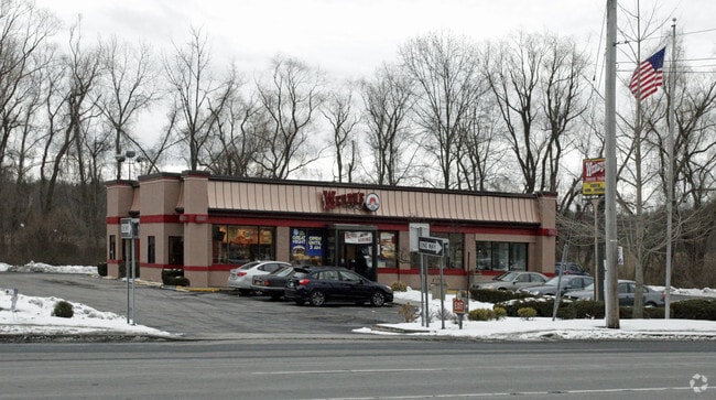
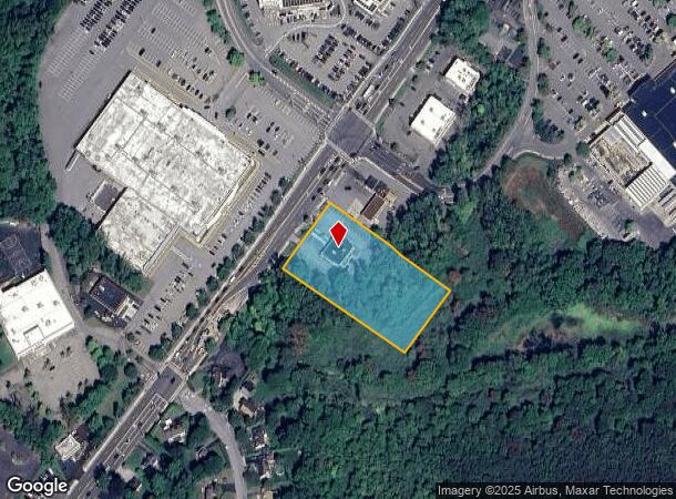
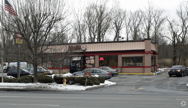
Property Record
3009 E Main St, Cortlandt Manor, NY 10567
NEARBY LISTINGS FOR SALE OR LEASE
Property Detail
3009 E Main St
2289-024-009-00004-000-0001
8.09B-000-001.05
Restaurantdrivein
Westchester
AE
New York
36119C0017F
1.000
2025
1.90 AC
2024
Northwest
014704
Westchester/So Connecticut
3,482 SF
New York-Jersey City-White Plains, NY-NJ
DEMOGRAPHICS near 3009 E Main St
1 Mile
3 Mile
5 Mile
2024 Total Population
5,516
52,787
83,588
2029 Population
5,284
51,506
81,698
Pop Growth 2024-2029
(4.21%)
(2.43%)
(2.26%)
Average Age
43
42
42
2024 Total Households
1,958
19,028
29,986
HH Growth 2024-2029
(4.49%)
(2.61%)
(2.47%)
Median Household Inc
$115,066
$107,905
$119,259
Avg Household Size
2.70
2.70
2.70
2024 Avg HH Vehicles
2.00
2.00
2.00
Median Home Value
$372,998
$403,205
$442,386
Median Year Built
1958
1962
1964
Nearby Places
- Restaurants
- Banks
- Shops
- Fitness
- Groceries
PUBLIC TRANSPORTATION
COMMUTER RAIL
Peekskill Station (Hudson Line - Metro-North Commuter Railroad Company (Metro-North))
DRIVE
WALK
Distance
Peekskill Station (Hudson Line - Metro-North Commuter Railroad Company (Metro-North))
6 min
3.7 mi
Cortlandt Station (Hudson Line - Metro-North Commuter Railroad Company (Metro-North))
DRIVE
WALK
Distance
Cortlandt Station (Hudson Line - Metro-North Commuter Railroad Company (Metro-North))
14 min
6.8 mi
AIRPORT
New York Stewart International
DRIVE
WALK
Distance
New York Stewart International
46 min
27.0 mi
Westchester County
DRIVE
WALK
Distance
Westchester County
39 min
28.4 mi
Freight Ports
NY - Red Hook Container Terminal
DRIVE
WALK
Distance
NY - Red Hook Container Terminal
81 min
55.7 mi
Nearby Properties
Address
Land Use
TOTAL SIZE
Lot Size
Zoning
Address
Land Use
TOTAL SIZE
Lot Size
Zoning
78,331 SF
37.78 AC
R2
Address
Land Use
TOTAL SIZE
Lot Size
Zoning
Address
Land Use
TOTAL SIZE
Lot Size
Zoning
Address
Land Use
TOTAL SIZE
Lot Size
Zoning
Address
Land Use
TOTAL SIZE
Lot Size
Zoning
13,520 SF
1.16 AC
CC1
Address
Land Use
TOTAL SIZE
Lot Size
Zoning
21,569 SF
61.43 AC
PD
Address
Land Use
TOTAL SIZE
Lot Size
Zoning
21,466 SF
2.87 AC
CC1
Address
Land Use
TOTAL SIZE
Lot Size
Zoning
13 AC
R1-40
Address
Land Use
TOTAL SIZE
Lot Size
Zoning
Address
Land Use
TOTAL SIZE
Lot Size
Zoning
Address
Land Use
TOTAL SIZE
Lot Size
Zoning
82.53 AC
Address
Land Use
TOTAL SIZE
Lot Size
Zoning
5,363 SF
4.82 AC
R2
Address
Land Use
TOTAL SIZE
Lot Size
Zoning
2.70 AC
Address
Land Use
TOTAL SIZE
Lot Size
Zoning
4,402 SF
5.38 AC
R2
Address
Land Use
TOTAL SIZE
Lot Size
Zoning
Address
Land Use
TOTAL SIZE
Lot Size
Zoning
Address
Land Use
TOTAL SIZE
Lot Size
Zoning
240.57 AC
CD
Address
Land Use
TOTAL SIZE
Lot Size
Zoning
22.61 AC
Address
Land Use
TOTAL SIZE
Lot Size
Zoning
8,834 SF
2.58 AC
CC1
Address
Land Use
TOTAL SIZE
Lot Size
Zoning
8.93 AC
Address
Land Use
TOTAL SIZE
Lot Size
Zoning
2.99 AC
Address
Land Use
TOTAL SIZE
Lot Size
Zoning
9,992 SF
15.01 AC
R2
Address
Land Use
TOTAL SIZE
Lot Size
Zoning
10,781 SF
9.29 AC
R2
Address
Land Use
TOTAL SIZE
Lot Size
Zoning
7,176 SF
4.86 AC
CC1
Address
Land Use
TOTAL SIZE
Lot Size
Zoning
9,454 SF
0.99 AC
LP
Address
Land Use
TOTAL SIZE
Lot Size
Zoning
Address
Land Use
TOTAL SIZE
Lot Size
Zoning
7.50 AC
Address
Land Use
TOTAL SIZE
Lot Size
Zoning
38.05 AC
Address
Land Use
TOTAL SIZE
Lot Size
Zoning
4,664 SF
0.55 AC
CC2
Address
Land Use
TOTAL SIZE
Lot Size
Zoning
3,421 SF
0.91 AC
CC1
The World's #1 Commercial Real Estate Marketplace
Connect with us
© 2025 CoStar Group
The information above has been obtained from sources believed reliable. While we do not doubt its accuracy we have not verified it and make no guarantee, warranty or representation about it. It is your responsibility to independently confirm its accuracy and completeness. Any projections, opinions, assumptions, or estimates used are for example only and do not represent the current or future performance of the property. The value of this transaction to you depends on tax and other factors which should be evaluated by your tax, financial, and legal advisors. You and your advisors should conduct a careful, independent investigation of the property to determine to your satisfaction the suitability of the property for your needs.