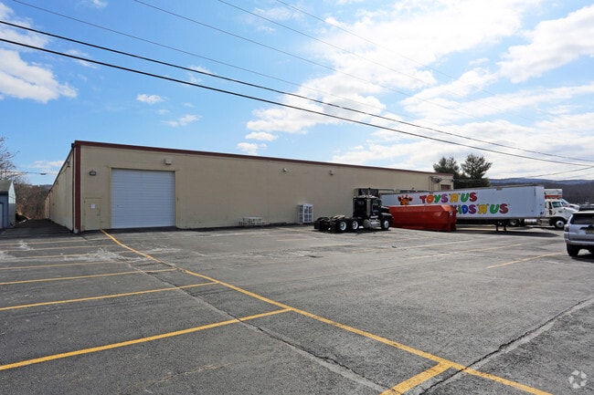
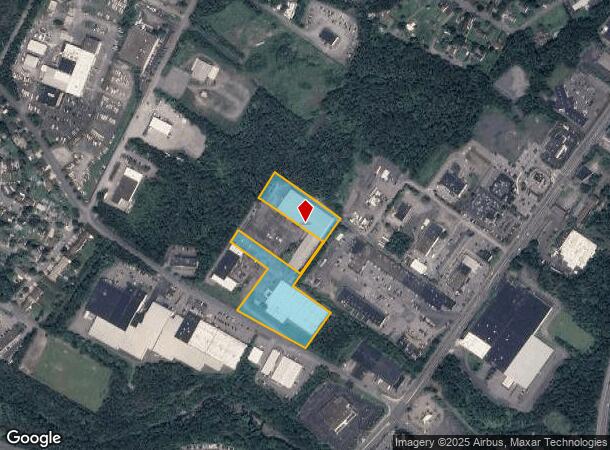
Property Record
300D East Ave, Wilkes Barre, PA 18702

Current Lease Availabilities
NEARBY LISTINGS FOR SALE OR LEASE
Property Detail
300D East Ave
Scranton--Wilkes-Barre--Hazelton, PA
LAIRD ST
50-H11S3-001-004-000
Luzerne
Lightindustrial
Pennsylvania
X
4
42079C0239E
6.36 AC
2025
I-81 Corridor
2025
Philadelphia
215200
DEMOGRAPHICS near 300D East Ave
1 Mile
3 Mile
5 Mile
2024 Total Population
4,334
37,241
119,397
2029 Population
4,292
37,115
119,278
Pop Growth 2024-2029
(0.97%)
(0.34%)
(0.10%)
Average Age
45
41
41
2024 Total Households
1,854
15,199
51,110
HH Growth 2024-2029
(1.19%)
(0.47%)
(0.15%)
Median Household Inc
$57,152
$53,272
$54,055
Avg Household Size
2.20
2.20
2.20
2024 Avg HH Vehicles
2.00
2.00
2.00
Median Home Value
$130,470
$113,792
$121,448
Median Year Built
1963
1951
1951
Nearby Places
Map Layers
Map Styles
 Street
 Aerial
- Restaurants
- Banks
- Shops
- Fitness
- Groceries
PUBLIC TRANSPORTATION
AIRPORT
Wilkes-Barre/Scranton International
DRIVE
WALK
Distance
Wilkes-Barre/Scranton International
15 min
10.0 mi
Nearby Properties
Address
Land Use
TOTAL SIZE
Lot Size
Zoning
Address
Land Use
TOTAL SIZE
Lot Size
Zoning
29.42 AC
Address
Land Use
TOTAL SIZE
Lot Size
Zoning
263.92 AC
Address
Land Use
TOTAL SIZE
Lot Size
Zoning
Address
Land Use
TOTAL SIZE
Lot Size
Zoning
50.81 AC
Address
Land Use
TOTAL SIZE
Lot Size
Zoning
132.36 AC
Address
Land Use
TOTAL SIZE
Lot Size
Zoning
46.26 AC
Address
Land Use
TOTAL SIZE
Lot Size
Zoning
44.09 AC
Address
Land Use
TOTAL SIZE
Lot Size
Zoning
80.97 AC
Address
Land Use
TOTAL SIZE
Lot Size
Zoning
Address
Land Use
TOTAL SIZE
Lot Size
Zoning
4.08 AC
Address
Land Use
TOTAL SIZE
Lot Size
Zoning
30.02 AC
Address
Land Use
TOTAL SIZE
Lot Size
Zoning
37.94 AC
Address
Land Use
TOTAL SIZE
Lot Size
Zoning
12.25 AC
Address
Land Use
TOTAL SIZE
Lot Size
Zoning
Address
Land Use
TOTAL SIZE
Lot Size
Zoning
14.33 AC
Address
Land Use
TOTAL SIZE
Lot Size
Zoning
11.69 AC
Address
Land Use
TOTAL SIZE
Lot Size
Zoning
Address
Land Use
TOTAL SIZE
Lot Size
Zoning
21.24 AC
Address
Land Use
TOTAL SIZE
Lot Size
Zoning
55.45 AC
Address
Land Use
TOTAL SIZE
Lot Size
Zoning
Address
Land Use
TOTAL SIZE
Lot Size
Zoning
77.69 AC
Address
Land Use
TOTAL SIZE
Lot Size
Zoning
1.36 AC
Address
Land Use
TOTAL SIZE
Lot Size
Zoning
7.74 AC
Address
Land Use
TOTAL SIZE
Lot Size
Zoning
43.01 AC
Address
Land Use
TOTAL SIZE
Lot Size
Zoning
12.60 AC
Address
Land Use
TOTAL SIZE
Lot Size
Zoning
16.96 AC
Address
Land Use
TOTAL SIZE
Lot Size
Zoning
9.15 AC
Address
Land Use
TOTAL SIZE
Lot Size
Zoning
Address
Land Use
TOTAL SIZE
Lot Size
Zoning
Address
Land Use
TOTAL SIZE
Lot Size
Zoning
9,437 AC
The World's #1 Commercial Real Estate Marketplace
Connect with us
© 2025 CoStar Group
The information above has been obtained from sources believed reliable. While we do not doubt its accuracy we have not verified it and make no guarantee, warranty or representation about it. It is your responsibility to independently confirm its accuracy and completeness. Any projections, opinions, assumptions, or estimates used are for example only and do not represent the current or future performance of the property. The value of this transaction to you depends on tax and other factors which should be evaluated by your tax, financial, and legal advisors. You and your advisors should conduct a careful, independent investigation of the property to determine to your satisfaction the suitability of the property for your needs.