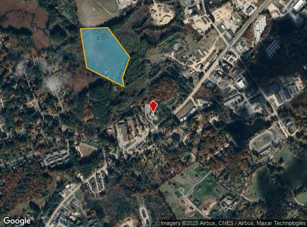
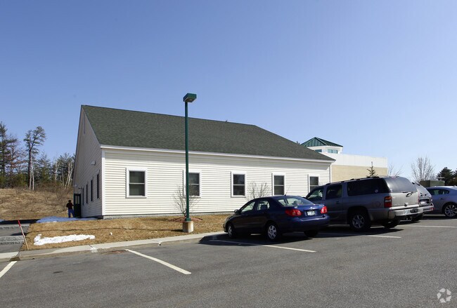
Property Record
300R Derry Rd, Hudson, NH 03051

NEARBY LISTINGS FOR SALE OR LEASE
-
-
View all Hudson listings for sale on LoopNet.com
Property Detail
300R Derry Rd
HDSO-000104-000001
Hillsborough
Minequarry
New Hampshire
X
22.26 AC
33011C0508D
Hillsborough
2024
Boston
2024
Manchester-Nashua, NH
012102
DEMOGRAPHICS near 300R Derry Rd
1 Mile
3 Mile
5 Mile
2024 Total Population
1,819
20,652
89,631
2029 Population
1,873
21,250
92,023
Pop Growth 2024-2029
+ 2.97%
+ 2.90%
+ 2.67%
Average Age
43
43
41
2024 Total Households
709
7,641
35,455
HH Growth 2024-2029
+ 2.96%
+ 2.87%
+ 2.63%
Median Household Inc
$110,539
$123,888
$98,943
Avg Household Size
2.60
2.70
2.50
2024 Avg HH Vehicles
2.00
2.00
2.00
Median Home Value
$393,301
$398,298
$383,230
Median Year Built
1985
1983
1978
Nearby Places
Map Layers
Map Styles
 Street
 Aerial
- Restaurants
- Banks
- Shops
- Fitness
- Groceries
PUBLIC TRANSPORTATION
AIRPORT
Manchester Boston Regional
DRIVE
WALK
Distance
Manchester Boston Regional
26 min
10.7 mi
Freight Ports
Port of Boston
DRIVE
WALK
Distance
Port of Boston
74 min
49.8 mi
Nearby Properties
Address
Land Use
TOTAL SIZE
Lot Size
Zoning
Address
Land Use
TOTAL SIZE
Lot Size
Zoning
26.55 AC
INDUST
Address
Land Use
TOTAL SIZE
Lot Size
Zoning
188,520 SF
111.12 AC
GD
Address
Land Use
TOTAL SIZE
Lot Size
Zoning
471,525 SF
40.78 AC
INDUST
Address
Land Use
TOTAL SIZE
Lot Size
Zoning
51,684 SF
36.58 AC
INDUST
Address
Land Use
TOTAL SIZE
Lot Size
Zoning
80,863 SF
18 AC
R1
Address
Land Use
TOTAL SIZE
Lot Size
Zoning
38 AC
RES
Address
Land Use
TOTAL SIZE
Lot Size
Zoning
17.55 AC
RES
Address
Land Use
TOTAL SIZE
Lot Size
Zoning
45,330 SF
1 AC
R3
Address
Land Use
TOTAL SIZE
Lot Size
Zoning
30.75 AC
RA
Address
Land Use
TOTAL SIZE
Lot Size
Zoning
69,900 SF
18.10 AC
BD
Address
Land Use
TOTAL SIZE
Lot Size
Zoning
44,280 SF
1 AC
R3
Address
Land Use
TOTAL SIZE
Lot Size
Zoning
2,400 SF
15.50 AC
G1
Address
Land Use
TOTAL SIZE
Lot Size
Zoning
120,684 SF
7.67 AC
INDUST
Address
Land Use
TOTAL SIZE
Lot Size
Zoning
31,091 SF
3.42 AC
BD
Address
Land Use
TOTAL SIZE
Lot Size
Zoning
115,747 SF
9.99 AC
ID
Address
Land Use
TOTAL SIZE
Lot Size
Zoning
684 SF
178.86 AC
G1
Address
Land Use
TOTAL SIZE
Lot Size
Zoning
8,596 SF
9.97 AC
GD
Address
Land Use
TOTAL SIZE
Lot Size
Zoning
5.74 AC
INDUST
Address
Land Use
TOTAL SIZE
Lot Size
Zoning
13,560 SF
27.43 AC
R2
Address
Land Use
TOTAL SIZE
Lot Size
Zoning
11.94 AC
I1/2
Address
Land Use
TOTAL SIZE
Lot Size
Zoning
9,800 SF
10.09 AC
B
Address
Land Use
TOTAL SIZE
Lot Size
Zoning
256.45 AC
TRANSI
Address
Land Use
TOTAL SIZE
Lot Size
Zoning
67.75 AC
I1/2
Address
Land Use
TOTAL SIZE
Lot Size
Zoning
24,225 SF
7 AC
AR-I
Address
Land Use
TOTAL SIZE
Lot Size
Zoning
13,231 SF
2.31 AC
ID
Address
Land Use
TOTAL SIZE
Lot Size
Zoning
600 SF
21.74 AC
ID
Address
Land Use
TOTAL SIZE
Lot Size
Zoning
9,600 SF
15.14 AC
C-II
Address
Land Use
TOTAL SIZE
Lot Size
Zoning
15.50 AC
RA
Address
Land Use
TOTAL SIZE
Lot Size
Zoning
26.38 AC
TRANSI
Address
Land Use
TOTAL SIZE
Lot Size
Zoning
15,253 SF
5.09 AC
G1
The World's #1 Commercial Real Estate Marketplace
Connect with us
© 2025 CoStar Group
The information above has been obtained from sources believed reliable. While we do not doubt its accuracy we have not verified it and make no guarantee, warranty or representation about it. It is your responsibility to independently confirm its accuracy and completeness. Any projections, opinions, assumptions, or estimates used are for example only and do not represent the current or future performance of the property. The value of this transaction to you depends on tax and other factors which should be evaluated by your tax, financial, and legal advisors. You and your advisors should conduct a careful, independent investigation of the property to determine to your satisfaction the suitability of the property for your needs.