Property Record
301 20Th St S, New Ulm, MN 56073


Property Detail
301 20Th St S
00105300102020
BRIDGE ST IND PARK 1ST ADD LOT-002 BLOCK-001 EXC SW'LY 200'
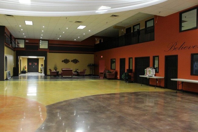
Nightclub
Brown
C2
Minnesota
B and X Area of moderate flood hazard, usually the area between the limits of the 100-year and 500-year floods.
2
2026
1.18 AC
2025
Minnesota South Area
960102
Other Market Areas
23,494 SF
New Ulm, MN
NEARBY LISTINGS FOR SALE OR LEASE
DEMOGRAPHICS near 301 20Th St S
1 mile
3 mile
5 mile
2025 Total Population
2,634
13,067
16,195
2030 Population
2,628
13,027
16,181
Pop Growth 2025-2030
(0.23%)
(0.31%)
(0.09%)
Average Age
42
42
42
2025 Total Households
1,099
5,443
6,885
HH Growth 2025-2030
(0.18%)
(0.31%)
(0.01%)
Median Household Inc
$69,760
$67,941
$68,080
Avg Household Size
2.20
2.20
2.20
2025 Avg HH Vehicles
2.00
2.00
2.00
Median Home Value
$215,397
$205,586
$218,162
Median Year Built
1975
1963
1968
Nearby Places
Map Layers
Map Styles
 Street
 Aerial
Layers
 Traffic
 Biking
Places
Listings with unknown addresses are not visible on the map
- Restaurants
- Banks
- Shops
- Fitness
- Groceries
SALE & LEASE HISTORY
LISTING DATE
SALE/LEASE

Sep 23, 2016
For Sale
Jul 20, 2017
For Sale
Jan 13, 2021
For Lease
Apr 04, 2019
For Sale
Nearby Properties
Address
Land Use
TOTAL SIZE
Lot Size
Zoning
Address
Land Use
TOTAL SIZE
Lot Size
Zoning
7,031 SF
2.27 AC
SF1
Address
Land Use
TOTAL SIZE
Lot Size
Zoning
167,000 SF
6 AC
Address
Land Use
TOTAL SIZE
Lot Size
Zoning
48,050 SF
7.97 AC
SF1
Address
Land Use
TOTAL SIZE
Lot Size
Zoning
140,108 SF
3.34 AC
MF1
Address
Land Use
TOTAL SIZE
Lot Size
Zoning
9,972 SF
2.74 AC
SF2
Address
Land Use
TOTAL SIZE
Lot Size
Zoning
28,355 SF
2.81 AC
SF2
Address
Land Use
TOTAL SIZE
Lot Size
Zoning
79,732 SF
65.25 AC
Address
Land Use
TOTAL SIZE
Lot Size
Zoning
23,584 SF
7.45 AC
MF1
Address
Land Use
TOTAL SIZE
Lot Size
Zoning
62,188 SF
7.16 AC
MF1
Address
Land Use
TOTAL SIZE
Lot Size
Zoning
4,669 SF
2.61 AC
Address
Land Use
TOTAL SIZE
Lot Size
Zoning
300 SF
14.24 AC
SF2
Address
Land Use
TOTAL SIZE
Lot Size
Zoning
59,132 SF
9.29 AC
SF1
Address
Land Use
TOTAL SIZE
Lot Size
Zoning
17.90 AC
A1
Address
Land Use
TOTAL SIZE
Lot Size
Zoning
26,381 SF
1.21 AC
SF2
Address
Land Use
TOTAL SIZE
Lot Size
Zoning
367,506 SF
15.65 AC
I2
Address
Land Use
TOTAL SIZE
Lot Size
Zoning
18,600 SF
2.13 AC
MF1
Address
Land Use
TOTAL SIZE
Lot Size
Zoning
9,565 SF
0.26 AC
SF2
Address
Land Use
TOTAL SIZE
Lot Size
Zoning
25,574 SF
2.81 AC
Address
Land Use
TOTAL SIZE
Lot Size
Zoning
Address
Land Use
TOTAL SIZE
Lot Size
Zoning
17,074 SF
0.38 AC
C3
Address
Land Use
TOTAL SIZE
Lot Size
Zoning
91,774 SF
3.13 AC
SF1
Address
Land Use
TOTAL SIZE
Lot Size
Zoning
21,080 SF
1.23 AC
SF2
Address
Land Use
TOTAL SIZE
Lot Size
Zoning
39,062 SF
0.65 AC
MF1
Address
Land Use
TOTAL SIZE
Lot Size
Zoning
9,342 SF
2.92 AC
MF1
Address
Land Use
TOTAL SIZE
Lot Size
Zoning
11,579 SF
1.33 AC
C3
Address
Land Use
TOTAL SIZE
Lot Size
Zoning
Address
Land Use
TOTAL SIZE
Lot Size
Zoning
216,900 SF
9.30 AC
I1
Address
Land Use
TOTAL SIZE
Lot Size
Zoning
0.79 AC
Address
Land Use
TOTAL SIZE
Lot Size
Zoning
21,047 SF
3.69 AC
C2
Address
Land Use
TOTAL SIZE
Lot Size
Zoning
7,848 SF
0.27 AC
C3
The World's #1 Commercial Real Estate Marketplace
Connect with us
© 2026 CoStar Group
The information above has been obtained from sources believed reliable. While we do not doubt its accuracy we have not verified it and make no guarantee, warranty or representation about it. It is your responsibility to independently confirm its accuracy and completeness. Any projections, opinions, assumptions, or estimates used are for example only and do not represent the current or future performance of the property. The value of this transaction to you depends on tax and other factors which should be evaluated by your tax, financial, and legal advisors. You and your advisors should conduct a careful, independent investigation of the property to determine to your satisfaction the suitability of the property for your needs.