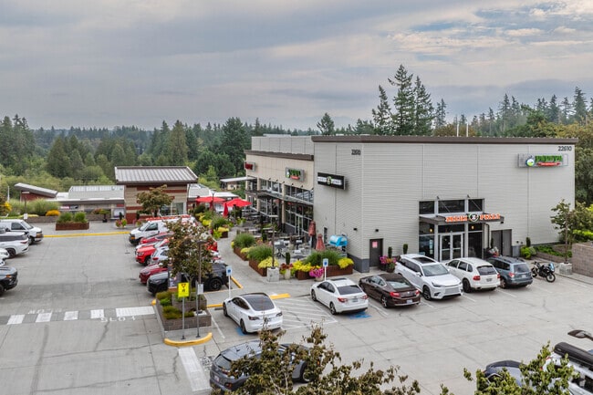
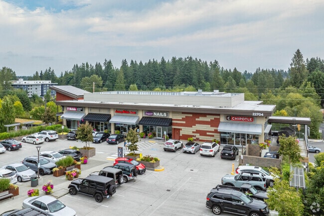
Property Record
301 228Th Ave Se, Sammamish, WA 98074

NEARBY LISTINGS FOR SALE OR LEASE
-
-
View all Sammamish listings for lease on LoopNet.com
Property Detail
301 228Th Ave Se
Seattle-Tacoma-Bellevue, WA
Sammamish Village Bsp
752705-0010
SAMMAMISH VILLAGE BSP (AKA SAMMAMISH BSP BSP2015-00314 REC 20160509900002 AND RE-REC 20160510001106)
Supermarket
King
X
Washington
53033C0685G
lot 1
2025
2.77 AC
2024
Coal Creek/Issaquah
032216
Seattle/Puget Sound
43,320 SF
DEMOGRAPHICS near 301 228Th Ave Se
1 Mile
3 Mile
5 Mile
2024 Total Population
11,457
61,607
163,472
2029 Population
11,664
61,895
164,243
Pop Growth 2024-2029
+ 1.81%
+ 0.47%
+ 0.47%
Average Age
36
39
38
2024 Total Households
3,787
20,431
58,372
HH Growth 2024-2029
+ 1.77%
+ 0.32%
+ 0.39%
Median Household Inc
$211,122
$209,944
$176,579
Avg Household Size
3.00
3.00
2.70
2024 Avg HH Vehicles
2.00
2.00
2.00
Median Home Value
$898,820
$1,029,277
$1,023,598
Median Year Built
1997
1993
1991
Nearby Places
Map Layers
Map Styles
 Street
 Aerial
- Restaurants
- Banks
- Shops
- Fitness
- Groceries
PUBLIC TRANSPORTATION
AIRPORT
Seattle-Tacoma International
DRIVE
WALK
Distance
Seattle-Tacoma International
42 min
26.1 mi
Seattle Paine Field International
DRIVE
WALK
Distance
Seattle Paine Field International
46 min
29.0 mi
Freight Ports
Port of Seattle
DRIVE
WALK
Distance
Port of Seattle
36 min
22.7 mi
SALE & LEASE HISTORY
LISTING DATE
SALE/LEASE

Oct 26, 2021
For Lease
May 23, 2018
For Lease
Nearby Properties
Address
Land Use
TOTAL SIZE
Lot Size
Zoning
Address
Land Use
TOTAL SIZE
Lot Size
Zoning
411,348 SF
11.65 AC
R18
Address
Land Use
TOTAL SIZE
Lot Size
Zoning
249,508 SF
14.79 AC
R18
Address
Land Use
TOTAL SIZE
Lot Size
Zoning
190,900 SF
15.71 AC
R12
Address
Land Use
TOTAL SIZE
Lot Size
Zoning
145,000 SF
34.09 AC
R4
Address
Land Use
TOTAL SIZE
Lot Size
Zoning
103,682 SF
39.46 AC
R1
Address
Land Use
TOTAL SIZE
Lot Size
Zoning
82,863 SF
4.23 AC
CB
Address
Land Use
TOTAL SIZE
Lot Size
Zoning
161,566 SF
20.76 AC
R6
Address
Land Use
TOTAL SIZE
Lot Size
Zoning
78,384 SF
2.34 AC
TC A2
Address
Land Use
TOTAL SIZE
Lot Size
Zoning
53,500 SF
32.68 AC
R6
Address
Land Use
TOTAL SIZE
Lot Size
Zoning
28,106 SF
28.86 AC
CF-F
Address
Land Use
TOTAL SIZE
Lot Size
Zoning
143.99 AC
CF-F
Address
Land Use
TOTAL SIZE
Lot Size
Zoning
68,000 SF
9.37 AC
TC D
Address
Land Use
TOTAL SIZE
Lot Size
Zoning
78,000 SF
16.02 AC
R4
Address
Land Use
TOTAL SIZE
Lot Size
Zoning
208,733 SF
5.17 AC
R4
Address
Land Use
TOTAL SIZE
Lot Size
Zoning
105,386 SF
19.50 AC
R6
Address
Land Use
TOTAL SIZE
Lot Size
Zoning
72,764 SF
13.50 AC
R1
Address
Land Use
TOTAL SIZE
Lot Size
Zoning
88,711 SF
4.97 AC
MF-H
Address
Land Use
TOTAL SIZE
Lot Size
Zoning
56,506 SF
7.17 AC
R6
Address
Land Use
TOTAL SIZE
Lot Size
Zoning
56,206 SF
18.69 AC
R4
Address
Land Use
TOTAL SIZE
Lot Size
Zoning
7,015 SF
4.95 AC
O
Address
Land Use
TOTAL SIZE
Lot Size
Zoning
66,000 SF
21.85 AC
RA5
Address
Land Use
TOTAL SIZE
Lot Size
Zoning
29,663 SF
129.40 AC
R4
Address
Land Use
TOTAL SIZE
Lot Size
Zoning
61,960 SF
7.95 AC
TC D
Address
Land Use
TOTAL SIZE
Lot Size
Zoning
10.08 AC
R18
Address
Land Use
TOTAL SIZE
Lot Size
Zoning
32,171 SF
4.32 AC
CB
Address
Land Use
TOTAL SIZE
Lot Size
Zoning
30,807 SF
21.54 AC
R6
Address
Land Use
TOTAL SIZE
Lot Size
Zoning
9,000 SF
4.50 AC
OP
Address
Land Use
TOTAL SIZE
Lot Size
Zoning
42,930 SF
2.79 AC
PO
The World's #1 Commercial Real Estate Marketplace
Connect with us
© 2026 CoStar Group
The information above has been obtained from sources believed reliable. While we do not doubt its accuracy we have not verified it and make no guarantee, warranty or representation about it. It is your responsibility to independently confirm its accuracy and completeness. Any projections, opinions, assumptions, or estimates used are for example only and do not represent the current or future performance of the property. The value of this transaction to you depends on tax and other factors which should be evaluated by your tax, financial, and legal advisors. You and your advisors should conduct a careful, independent investigation of the property to determine to your satisfaction the suitability of the property for your needs.