Property Record
301 27Th St Se, Ruskin, FL 33570

NEARBY LISTINGS FOR SALE OR LEASE
-
-
View all Ruskin listings for sale on LoopNet.com
Property Detail
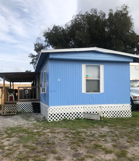
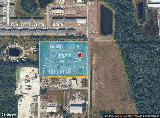
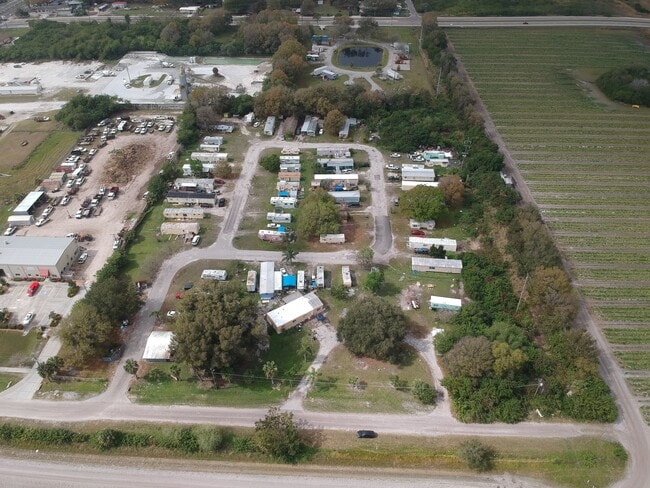
301 27Th St Se
Tampa-St. Petersburg-Clearwater, FL
Ruskin Colony Farms 1St Extension
U-10-32-19-1US-000000-00469.1
Hillsborough
Mobilemanufacturedhomeregardlessoflandownership
Florida
X
6.69 AC
12057C0659J
Southeast Tampa
890 SF
Tampa/St Petersburg
DEMOGRAPHICS near 301 27Th St Se
1 Mile
3 Mile
5 Mile
2024 Total Population
5,741
59,770
121,767
2029 Population
6,458
67,512
137,172
Pop Growth 2024-2029
+ 12.49%
+ 12.95%
+ 12.65%
Average Age
33
47
46
2024 Total Households
1,718
24,040
48,740
HH Growth 2024-2029
+ 12.63%
+ 13.25%
+ 12.69%
Median Household Inc
$73,019
$64,685
$72,256
Avg Household Size
3.20
2.40
2.40
2024 Avg HH Vehicles
2.00
2.00
2.00
Median Home Value
$196,614
$241,022
$275,232
Median Year Built
2010
2004
2005
Nearby Places
Map Layers
Map Styles
 Street
 Aerial
- Restaurants
- Banks
- Shops
- Fitness
- Groceries
PUBLIC TRANSPORTATION
AIRPORT
Sarasota/Bradenton International
DRIVE
WALK
Distance
Sarasota/Bradenton International
44 min
29.4 mi
Tampa International
DRIVE
WALK
Distance
Tampa International
46 min
34.8 mi
St Pete-Clearwater International
DRIVE
WALK
Distance
St Pete-Clearwater International
62 min
45.9 mi
Freight Ports
Port Manatee
DRIVE
WALK
Distance
Port Manatee
21 min
12.7 mi
SALE & LEASE HISTORY
LISTING DATE
SALE/LEASE

Jan 31, 2020
For Sale
Nearby Properties
Address
Land Use
TOTAL SIZE
Lot Size
Zoning
Address
Land Use
TOTAL SIZE
Lot Size
Zoning
1,026,563 SF
79.54 AC
PD
Address
Land Use
TOTAL SIZE
Lot Size
Zoning
351,758 SF
63.45 AC
PD
Address
Land Use
TOTAL SIZE
Lot Size
Zoning
334,559 SF
27.53 AC
PD
Address
Land Use
TOTAL SIZE
Lot Size
Zoning
35,855 SF
38.61 AC
PD
Address
Land Use
TOTAL SIZE
Lot Size
Zoning
365,695 SF
17.84 AC
PD-MU
Address
Land Use
TOTAL SIZE
Lot Size
Zoning
290,432 SF
45.44 AC
PD
Address
Land Use
TOTAL SIZE
Lot Size
Zoning
190,908 SF
49.11 AC
PD
Address
Land Use
TOTAL SIZE
Lot Size
Zoning
138,397 SF
36.94 AC
PD
Address
Land Use
TOTAL SIZE
Lot Size
Zoning
75,713 SF
7.40 AC
PD
Address
Land Use
TOTAL SIZE
Lot Size
Zoning
122,657 SF
17.11 AC
PD
Address
Land Use
TOTAL SIZE
Lot Size
Zoning
77,315 SF
9.71 AC
CG
Address
Land Use
TOTAL SIZE
Lot Size
Zoning
295,588 SF
10.80 AC
PD-MU
Address
Land Use
TOTAL SIZE
Lot Size
Zoning
144,868 SF
17.10 AC
PD
Address
Land Use
TOTAL SIZE
Lot Size
Zoning
94,955 SF
13.55 AC
PD
Address
Land Use
TOTAL SIZE
Lot Size
Zoning
230,880 SF
25.13 AC
AI
Address
Land Use
TOTAL SIZE
Lot Size
Zoning
58,368 SF
9.15 AC
PD
Address
Land Use
TOTAL SIZE
Lot Size
Zoning
137,465 SF
10.30 AC
PD
Address
Land Use
TOTAL SIZE
Lot Size
Zoning
131,647 SF
9.98 AC
PD
Address
Land Use
TOTAL SIZE
Lot Size
Zoning
51,900 SF
47.60 AC
PD
Address
Land Use
TOTAL SIZE
Lot Size
Zoning
61,680 SF
20.16 AC
PD
Address
Land Use
TOTAL SIZE
Lot Size
Zoning
1,325 SF
2.69 AC
PD
Address
Land Use
TOTAL SIZE
Lot Size
Zoning
89,847 SF
8.56 AC
PD
Address
Land Use
TOTAL SIZE
Lot Size
Zoning
113,683 SF
14.51 AC
PD
Address
Land Use
TOTAL SIZE
Lot Size
Zoning
131,155 SF
18.31 AC
PD
Address
Land Use
TOTAL SIZE
Lot Size
Zoning
100,134 SF
10.45 AC
PD
Address
Land Use
TOTAL SIZE
Lot Size
Zoning
60,242 SF
6.05 AC
PD
Address
Land Use
TOTAL SIZE
Lot Size
Zoning
41,031 SF
12.16 AC
CN
Address
Land Use
TOTAL SIZE
Lot Size
Zoning
119,624 SF
13.03 AC
M
Address
Land Use
TOTAL SIZE
Lot Size
Zoning
97,398 SF
12.45 AC
RDC-12
Address
Land Use
TOTAL SIZE
Lot Size
Zoning
54,228 SF
2.85 AC
PD
The World's #1 Commercial Real Estate Marketplace
Connect with us
© 2025 CoStar Group
The information above has been obtained from sources believed reliable. While we do not doubt its accuracy we have not verified it and make no guarantee, warranty or representation about it. It is your responsibility to independently confirm its accuracy and completeness. Any projections, opinions, assumptions, or estimates used are for example only and do not represent the current or future performance of the property. The value of this transaction to you depends on tax and other factors which should be evaluated by your tax, financial, and legal advisors. You and your advisors should conduct a careful, independent investigation of the property to determine to your satisfaction the suitability of the property for your needs.