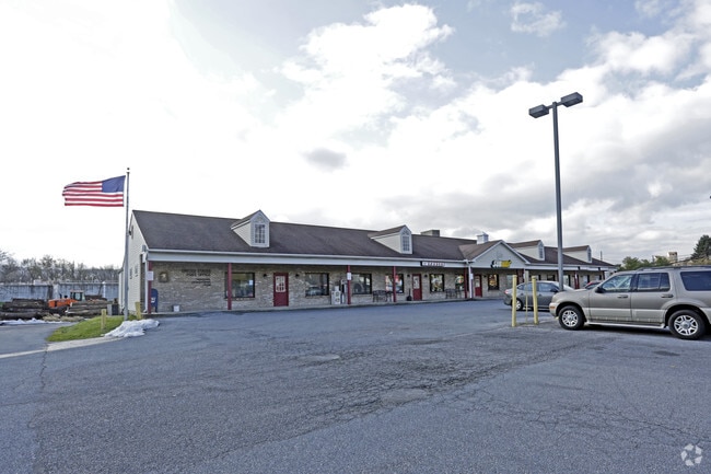
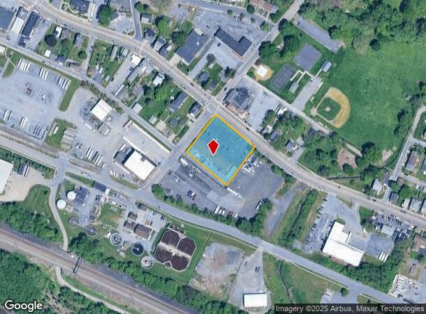
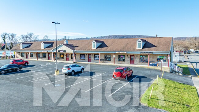
Property Record
301 2Nd St, Highspire, PA 17034
NEARBY LISTINGS FOR SALE OR LEASE
-
-
View all Highspire listings for lease on LoopNet.com
Property Detail
301 2Nd St
Commercialofficeresidentialmixeduse
Dauphin
AE
Pennsylvania
42133C0058F
0.95 AC
2025
Harrisburg Area East
2025
Philadelphia
023500
Harrisburg-Carlisle, PA
7,200 SF
30-018-013
DEMOGRAPHICS near 301 2Nd St
1 Mile
3 Mile
5 Mile
2024 Total Population
4,911
26,117
96,098
2029 Population
4,993
26,674
98,216
Pop Growth 2024-2029
+ 1.67%
+ 2.13%
+ 2.20%
Average Age
40
40
40
2024 Total Households
2,141
10,367
38,106
HH Growth 2024-2029
+ 1.73%
+ 2.22%
+ 2.31%
Median Household Inc
$59,632
$67,000
$69,105
Avg Household Size
2.30
2.40
2.40
2024 Avg HH Vehicles
2.00
2.00
2.00
Median Home Value
$138,727
$170,096
$177,052
Median Year Built
1969
1971
1970
Nearby Places
Map Layers
Map Styles
 Street
 Aerial
- Restaurants
- Banks
- Shops
- Fitness
- Groceries
PUBLIC TRANSPORTATION
COMMUTER RAIL
Middletown (Keystone Service - Amtrak)
DRIVE
WALK
Distance
Middletown (Keystone Service - Amtrak)
6 min
3.1 mi
Harrisburg (Keystone Service - Amtrak, Pennsylvanian - Amtrak)
DRIVE
WALK
Distance
Harrisburg (Keystone Service - Amtrak, Pennsylvanian - Amtrak)
14 min
7.5 mi
AIRPORT
Harrisburg International
DRIVE
WALK
Distance
Harrisburg International
6 min
2.4 mi
Freight Ports
Port of Baltimore
DRIVE
WALK
Distance
Port of Baltimore
114 min
83.3 mi
SALE & LEASE HISTORY
LISTING DATE
SALE/LEASE

Jul 28, 2017
For Sale
Feb 25, 2019
For Lease
Apr 01, 2025
For Lease
Nearby Properties
Address
Land Use
TOTAL SIZE
Lot Size
Zoning
Address
Land Use
TOTAL SIZE
Lot Size
Zoning
5,737 SF
592.08 AC
Address
Land Use
TOTAL SIZE
Lot Size
Zoning
185,784 SF
173.81 AC
Address
Land Use
TOTAL SIZE
Lot Size
Zoning
72,186 SF
117.61 AC
Address
Land Use
TOTAL SIZE
Lot Size
Zoning
240,000 SF
68.73 AC
Address
Land Use
TOTAL SIZE
Lot Size
Zoning
29,440 SF
82.92 AC
Address
Land Use
TOTAL SIZE
Lot Size
Zoning
142,010 SF
53.46 AC
Address
Land Use
TOTAL SIZE
Lot Size
Zoning
50,963 SF
46.61 AC
Address
Land Use
TOTAL SIZE
Lot Size
Zoning
651,250 SF
47.13 AC
Address
Land Use
TOTAL SIZE
Lot Size
Zoning
40,000 SF
48.30 AC
Address
Land Use
TOTAL SIZE
Lot Size
Zoning
2,068 SF
19.26 AC
Address
Land Use
TOTAL SIZE
Lot Size
Zoning
167,713 SF
11.50 AC
Address
Land Use
TOTAL SIZE
Lot Size
Zoning
348,615 SF
38.98 AC
Address
Land Use
TOTAL SIZE
Lot Size
Zoning
165,549 SF
65.10 AC
Address
Land Use
TOTAL SIZE
Lot Size
Zoning
2,400 SF
9.11 AC
Address
Land Use
TOTAL SIZE
Lot Size
Zoning
1,254 SF
25.34 AC
Address
Land Use
TOTAL SIZE
Lot Size
Zoning
320,000 SF
16.71 AC
Address
Land Use
TOTAL SIZE
Lot Size
Zoning
83,505 SF
11.50 AC
Address
Land Use
TOTAL SIZE
Lot Size
Zoning
7,655 SF
219.86 AC
Address
Land Use
TOTAL SIZE
Lot Size
Zoning
132,588 SF
18.49 AC
Address
Land Use
TOTAL SIZE
Lot Size
Zoning
137,640 SF
12.87 AC
Address
Land Use
TOTAL SIZE
Lot Size
Zoning
64,856 SF
12.04 AC
Address
Land Use
TOTAL SIZE
Lot Size
Zoning
56.58 AC
Address
Land Use
TOTAL SIZE
Lot Size
Zoning
214,400 SF
14.74 AC
Address
Land Use
TOTAL SIZE
Lot Size
Zoning
92,197 SF
9.81 AC
Address
Land Use
TOTAL SIZE
Lot Size
Zoning
131,044 SF
43.73 AC
Address
Land Use
TOTAL SIZE
Lot Size
Zoning
68,285 SF
2.77 AC
Address
Land Use
TOTAL SIZE
Lot Size
Zoning
2,224 SF
7.34 AC
Address
Land Use
TOTAL SIZE
Lot Size
Zoning
125,718 SF
20.32 AC
Address
Land Use
TOTAL SIZE
Lot Size
Zoning
189,248 SF
15.03 AC
Address
Land Use
TOTAL SIZE
Lot Size
Zoning
73,622 SF
13.90 AC
The World's #1 Commercial Real Estate Marketplace
Connect with us
© 2025 CoStar Group
The information above has been obtained from sources believed reliable. While we do not doubt its accuracy we have not verified it and make no guarantee, warranty or representation about it. It is your responsibility to independently confirm its accuracy and completeness. Any projections, opinions, assumptions, or estimates used are for example only and do not represent the current or future performance of the property. The value of this transaction to you depends on tax and other factors which should be evaluated by your tax, financial, and legal advisors. You and your advisors should conduct a careful, independent investigation of the property to determine to your satisfaction the suitability of the property for your needs.