Property Record
301 2Nd St, Liverpool, NY 13088
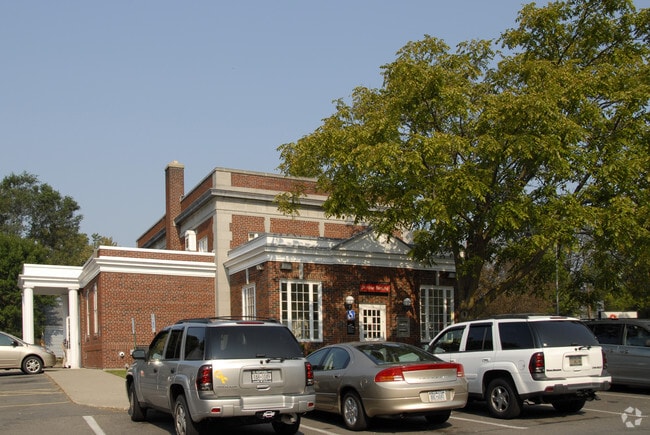

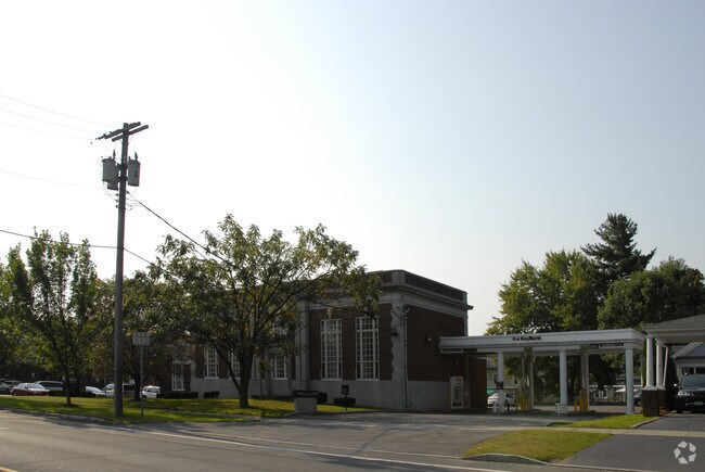
Property Detail
301 2Nd St
314801-005-000-0008-006-000-0000
BLK 25 LT 39
Financialbuilding
Onondaga
05 - COMME
New York
B and X Area of moderate flood hazard, usually the area between the limits of the 100-year and 500-year floods.
6.000
2025
0.50 AC
2025
NE Outer Onondaga County
013300
Syracuse
3,120 SF
Syracuse, NY
NEARBY LISTINGS FOR SALE OR LEASE
DEMOGRAPHICS near 301 2Nd St
1 mile
3 mile
5 mile
2025 Total Population
5,198
43,094
157,399
2030 Population
5,152
42,424
155,415
Pop Growth 2025-2030
(0.88%)
(1.55%)
(1.26%)
Average Age
43
42
41
2025 Total Households
2,546
19,243
68,137
HH Growth 2025-2030
(1.10%)
(1.65%)
(1.24%)
Median Household Inc
$75,448
$75,954
$66,486
Avg Household Size
2.00
2.10
2.20
2025 Avg HH Vehicles
2.00
2.00
1.00
Median Home Value
$169,843
$179,799
$170,611
Median Year Built
1958
1968
1958
Nearby Places
Map Layers
Map Styles
 Street
 Aerial
Layers
 Traffic
 Biking
Places
Listings with unknown addresses are not visible on the map
- Restaurants
- Banks
- Shops
- Fitness
- Groceries
PUBLIC TRANSPORTATION
COMMUTER RAIL
Syracuse Regional Transportation Center (Empire Service - Amtrak, Lake Shore Limited - Amtrak, Maple Leaf - Amtrak)
Drive
Walk
Distance
Syracuse Regional Transportation Center (Empire Service - Amtrak, Lake Shore Limited - Amtrak, Maple Leaf - Amtrak)
6 min
3.1 mi
AIRPORT
Syracuse Hancock International
Drive
Walk
Distance
Syracuse Hancock International
13 min
6.8 mi
Freight Ports
Albany, NY Port
Drive
Walk
Distance
Albany, NY Port
174 min
146.2 mi
Nearby Properties
Address
Land Use
TOTAL SIZE
Lot Size
Zoning
Address
Land Use
TOTAL SIZE
Lot Size
Zoning
847,042 SF
42.78 AC
23
Address
Land Use
TOTAL SIZE
Lot Size
Zoning
7,392 SF
14.86 AC
03 - MULTI
Address
Land Use
TOTAL SIZE
Lot Size
Zoning
11,484 SF
16.36 AC
03 - MULTI
Address
Land Use
TOTAL SIZE
Lot Size
Zoning
408,000 SF
17.57 AC
06 - INDUS
Address
Land Use
TOTAL SIZE
Lot Size
Zoning
77,150 SF
159.25 AC
06 - INDUS
Address
Land Use
TOTAL SIZE
Lot Size
Zoning
3,968 SF
14.31 AC
03 - MULTI
Address
Land Use
TOTAL SIZE
Lot Size
Zoning
7,229 SF
111.29 AC
05 - COMME
Address
Land Use
TOTAL SIZE
Lot Size
Zoning
11,952 SF
9.14 AC
03 - MULTI
Address
Land Use
TOTAL SIZE
Lot Size
Zoning
38,000 SF
9.90 AC
22
Address
Land Use
TOTAL SIZE
Lot Size
Zoning
3.59 AC
04 - FARM
Address
Land Use
TOTAL SIZE
Lot Size
Zoning
65,027 SF
262.57 AC
06 - INDUS
Address
Land Use
TOTAL SIZE
Lot Size
Zoning
71,074 SF
27.78 AC
02 - SINGL
Address
Land Use
TOTAL SIZE
Lot Size
Zoning
78,656 SF
9.14 AC
06 - INDUS
Address
Land Use
TOTAL SIZE
Lot Size
Zoning
32,586 SF
6.87 AC
06 - INDUS
Address
Land Use
TOTAL SIZE
Lot Size
Zoning
57,993 SF
18.43 AC
02 - SINGL
Address
Land Use
TOTAL SIZE
Lot Size
Zoning
118,651 SF
12.27 AC
02 - SINGL
Address
Land Use
TOTAL SIZE
Lot Size
Zoning
17,240 SF
6.49 AC
03 - MULTI
Address
Land Use
TOTAL SIZE
Lot Size
Zoning
3,744 SF
10.60 AC
03 - MULTI
Address
Land Use
TOTAL SIZE
Lot Size
Zoning
3,696 SF
10.12 AC
03 - MULTI
Address
Land Use
TOTAL SIZE
Lot Size
Zoning
2,624 SF
252.09 AC
06 - INDUS
Address
Land Use
TOTAL SIZE
Lot Size
Zoning
71,194 SF
10.76 AC
02 - SINGL
Address
Land Use
TOTAL SIZE
Lot Size
Zoning
109,642 SF
22.17 AC
06 - INDUS
Address
Land Use
TOTAL SIZE
Lot Size
Zoning
96,084 SF
8.74 AC
06 - INDUS
Address
Land Use
TOTAL SIZE
Lot Size
Zoning
66,476 SF
7.68 AC
03 - MULTI
Address
Land Use
TOTAL SIZE
Lot Size
Zoning
11,059 SF
8.23 AC
06 - INDUS
Address
Land Use
TOTAL SIZE
Lot Size
Zoning
120,000 SF
2.21 AC
22
Address
Land Use
TOTAL SIZE
Lot Size
Zoning
64,833 SF
3.25 AC
05 - COMME
Address
Land Use
TOTAL SIZE
Lot Size
Zoning
57,993 SF
16.80 AC
02 - SINGL
Address
Land Use
TOTAL SIZE
Lot Size
Zoning
21,309 SF
31.51 AC
22
Address
Land Use
TOTAL SIZE
Lot Size
Zoning
14,508 SF
8.74 AC
03 - MULTI
The World's #1 Commercial Real Estate Marketplace
Connect with us
© 2026 CoStar Group
The information above has been obtained from sources believed reliable. While we do not doubt its accuracy we have not verified it and make no guarantee, warranty or representation about it. It is your responsibility to independently confirm its accuracy and completeness. Any projections, opinions, assumptions, or estimates used are for example only and do not represent the current or future performance of the property. The value of this transaction to you depends on tax and other factors which should be evaluated by your tax, financial, and legal advisors. You and your advisors should conduct a careful, independent investigation of the property to determine to your satisfaction the suitability of the property for your needs.