Property Record
301 Aloha Way, Hampstead, NC 28443
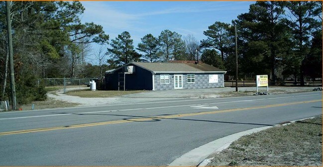

Property Detail
301 Aloha Way
4225-08-2988-0000
LT 2 PB 39/117 LOWES HOME CENTER SURVEY
Medicalbuilding
Pender
SEEMAP
North Carolina
B and X Area of moderate flood hazard, usually the area between the limits of the 100-year and 500-year floods.
2
2025
2.65 AC
2025
East Pender County
920104
Wilmington
9,021 SF
Wilmington, NC
NEARBY LISTINGS FOR SALE OR LEASE
DEMOGRAPHICS near 301 Aloha Way
1 mile
3 mile
5 mile
2025 Total Population
1,683
10,316
23,063
2030 Population
1,916
11,810
26,307
Pop Growth 2025-2030
+ 13.84%
+ 14.48%
+ 14.07%
Average Age
41
40
41
2025 Total Households
627
3,937
9,079
HH Growth 2025-2030
+ 14.19%
+ 14.88%
+ 14.63%
Median Household Inc
$95,959
$82,323
$85,995
Avg Household Size
2.70
2.60
2.50
2025 Avg HH Vehicles
2.00
2.00
2.00
Median Home Value
$437,956
$375,261
$410,121
Median Year Built
2007
2002
2001
Nearby Places
Map Layers
Map Styles
 Street
 Aerial
Layers
 Traffic
 Biking
Places
Listings with unknown addresses are not visible on the map
- Restaurants
- Banks
- Shops
- Fitness
- Groceries
PUBLIC TRANSPORTATION
AIRPORT
Wilmington International
Drive
Walk
Distance
Wilmington International
42 min
27.3 mi
Albert J Ellis
Drive
Walk
Distance
Albert J Ellis
59 min
36.8 mi
Freight Ports
Port of Wilmington
Drive
Walk
Distance
Port of Wilmington
50 min
29.2 mi
SALE & LEASE HISTORY
LISTING DATE
SALE/LEASE

Jan 06, 2017
For Sale
Apr 13, 2017
For Lease
Nearby Properties
Address
Land Use
TOTAL SIZE
Lot Size
Zoning
Address
Land Use
TOTAL SIZE
Lot Size
Zoning
333,789 SF
1 AC
RP
Address
Land Use
TOTAL SIZE
Lot Size
Zoning
151,776 SF
32.21 AC
SEEMAP
Address
Land Use
TOTAL SIZE
Lot Size
Zoning
104,760 SF
20 AC
Address
Land Use
TOTAL SIZE
Lot Size
Zoning
60,562 SF
9.34 AC
SEEMAP
Address
Land Use
TOTAL SIZE
Lot Size
Zoning
138,492 SF
32.99 AC
SEEMAP
Address
Land Use
TOTAL SIZE
Lot Size
Zoning
42,232 SF
6.23 AC
SEEMAP
Address
Land Use
TOTAL SIZE
Lot Size
Zoning
46,080 SF
7.41 AC
Address
Land Use
TOTAL SIZE
Lot Size
Zoning
22,068 SF
3.13 AC
B2
Address
Land Use
TOTAL SIZE
Lot Size
Zoning
35,205 SF
5.86 AC
SEEMAP
Address
Land Use
TOTAL SIZE
Lot Size
Zoning
23,444 SF
5.17 AC
SEEMAP
Address
Land Use
TOTAL SIZE
Lot Size
Zoning
13,836 SF
1 AC
SEEMAP
Address
Land Use
TOTAL SIZE
Lot Size
Zoning
8,331 SF
2.17 AC
SEEMAP
Address
Land Use
TOTAL SIZE
Lot Size
Zoning
11,534 SF
1 AC
SEEMAP
Address
Land Use
TOTAL SIZE
Lot Size
Zoning
11,500 SF
1.59 AC
C1
Address
Land Use
TOTAL SIZE
Lot Size
Zoning
13,606 SF
1.52 AC
SEEMAP
Address
Land Use
TOTAL SIZE
Lot Size
Zoning
7,828 SF
2.89 AC
SEEMAP
Address
Land Use
TOTAL SIZE
Lot Size
Zoning
9,190 SF
1.20 AC
FA
Address
Land Use
TOTAL SIZE
Lot Size
Zoning
22,584 SF
3.35 AC
SEEMAP
Address
Land Use
TOTAL SIZE
Lot Size
Zoning
6,500 SF
34.41 AC
SEEMAP
Address
Land Use
TOTAL SIZE
Lot Size
Zoning
16,072 SF
3.18 AC
PD
Address
Land Use
TOTAL SIZE
Lot Size
Zoning
11,280 SF
0.95 AC
B2
Address
Land Use
TOTAL SIZE
Lot Size
Zoning
18,000 SF
4.64 AC
B2RA
Address
Land Use
TOTAL SIZE
Lot Size
Zoning
1,538 SF
15.58 AC
RA
Address
Land Use
TOTAL SIZE
Lot Size
Zoning
17,500 SF
5.94 AC
RT
Address
Land Use
TOTAL SIZE
Lot Size
Zoning
47,790 SF
18.50 AC
SEEMAP
Address
Land Use
TOTAL SIZE
Lot Size
Zoning
10,585 SF
1.16 AC
SEEMAP
Address
Land Use
TOTAL SIZE
Lot Size
Zoning
4,700 SF
13 AC
FA
Address
Land Use
TOTAL SIZE
Lot Size
Zoning
4,498 SF
1.21 AC
SEEMAP
Address
Land Use
TOTAL SIZE
Lot Size
Zoning
12.21 AC
SEEMAP
The World's #1 Commercial Real Estate Marketplace
Connect with us
© 2026 CoStar Group
The information above has been obtained from sources believed reliable. While we do not doubt its accuracy we have not verified it and make no guarantee, warranty or representation about it. It is your responsibility to independently confirm its accuracy and completeness. Any projections, opinions, assumptions, or estimates used are for example only and do not represent the current or future performance of the property. The value of this transaction to you depends on tax and other factors which should be evaluated by your tax, financial, and legal advisors. You and your advisors should conduct a careful, independent investigation of the property to determine to your satisfaction the suitability of the property for your needs.