Property Record
301 Altezza Dr, Pharr, TX 78577
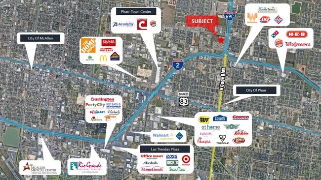


NEARBY LISTINGS FOR SALE OR LEASE
Property Detail
301 Altezza Dr
McAllen/Edinburg/Pharr
Altezza - Spa
McAllen-Edinburg-Mission, TX
ALTEZZA LOT 1
A3487-00-000-0001-00
Hidalgo
Vacantlandnec
Texas
2024
1
2025
4.32 AC
021407
Pharr
DEMOGRAPHICS near 301 Altezza Dr
1 Mile
3 Mile
5 Mile
2024 Total Population
12,780
112,086
242,705
2029 Population
13,506
119,582
257,128
Pop Growth 2024-2029
+ 5.68%
+ 6.69%
+ 5.94%
Average Age
34
36
36
2024 Total Households
3,895
37,137
79,640
HH Growth 2024-2029
+ 5.52%
+ 6.88%
+ 6.01%
Median Household Inc
$31,654
$45,687
$47,029
Avg Household Size
3.10
2.90
2.90
2024 Avg HH Vehicles
2.00
2.00
2.00
Median Home Value
$76,101
$110,819
$129,708
Median Year Built
1997
1997
1996
Nearby Places
Map Layers
Map Styles
 Street
 Aerial
- Restaurants
- Banks
- Shops
- Fitness
- Groceries
PUBLIC TRANSPORTATION
AIRPORT
McAllen International
DRIVE
WALK
Distance
McAllen International
9 min
5.1 mi
Freight Ports
Port of Brownsville
DRIVE
WALK
Distance
Port of Brownsville
64 min
56.3 mi
SALE & LEASE HISTORY
LISTING DATE
SALE/LEASE

Feb 18, 2022
For Sale
Nearby Properties
Address
Land Use
TOTAL SIZE
Lot Size
Zoning
Address
Land Use
TOTAL SIZE
Lot Size
Zoning
347,628 SF
13.03 AC
CO
Address
Land Use
TOTAL SIZE
Lot Size
Zoning
390,048 SF
30.30 AC
Address
Land Use
TOTAL SIZE
Lot Size
Zoning
2 SF
38 AC
RS
Address
Land Use
TOTAL SIZE
Lot Size
Zoning
1 SF
9.36 AC
Address
Land Use
TOTAL SIZE
Lot Size
Zoning
252,435 SF
9.09 AC
Address
Land Use
TOTAL SIZE
Lot Size
Zoning
175,594 SF
24.77 AC
Address
Land Use
TOTAL SIZE
Lot Size
Zoning
1 SF
39.94 AC
CO
Address
Land Use
TOTAL SIZE
Lot Size
Zoning
7.50 AC
Address
Land Use
TOTAL SIZE
Lot Size
Zoning
202,204 SF
19.43 AC
Address
Land Use
TOTAL SIZE
Lot Size
Zoning
15,542 SF
34.23 AC
Address
Land Use
TOTAL SIZE
Lot Size
Zoning
115,998 SF
6.73 AC
Address
Land Use
TOTAL SIZE
Lot Size
Zoning
140,904 SF
33.98 AC
Address
Land Use
TOTAL SIZE
Lot Size
Zoning
254,477 SF
51.88 AC
Address
Land Use
TOTAL SIZE
Lot Size
Zoning
79,150 SF
10.24 AC
Address
Land Use
TOTAL SIZE
Lot Size
Zoning
123,548 SF
10.70 AC
Address
Land Use
TOTAL SIZE
Lot Size
Zoning
135,948 SF
2.87 AC
Address
Land Use
TOTAL SIZE
Lot Size
Zoning
84,335 SF
5.79 AC
CO
Address
Land Use
TOTAL SIZE
Lot Size
Zoning
112,792 SF
29 AC
Address
Land Use
TOTAL SIZE
Lot Size
Zoning
2 SF
92.29 AC
CO
Address
Land Use
TOTAL SIZE
Lot Size
Zoning
121,353 SF
4.59 AC
Address
Land Use
TOTAL SIZE
Lot Size
Zoning
13,632 SF
17 AC
Address
Land Use
TOTAL SIZE
Lot Size
Zoning
66,605 SF
10.05 AC
Address
Land Use
TOTAL SIZE
Lot Size
Zoning
16.83 AC
CO
Address
Land Use
TOTAL SIZE
Lot Size
Zoning
208,104 SF
15.65 AC
Address
Land Use
TOTAL SIZE
Lot Size
Zoning
100,318 SF
3.65 AC
Address
Land Use
TOTAL SIZE
Lot Size
Zoning
67,995 SF
21.10 AC
Address
Land Use
TOTAL SIZE
Lot Size
Zoning
143,400 SF
9.36 AC
Address
Land Use
TOTAL SIZE
Lot Size
Zoning
82,448 SF
4.36 AC
Address
Land Use
TOTAL SIZE
Lot Size
Zoning
170,694 SF
27.21 AC
Address
Land Use
TOTAL SIZE
Lot Size
Zoning
78,524 SF
3.83 AC
The World's #1 Commercial Real Estate Marketplace
Connect with us
© 2025 CoStar Group
The information above has been obtained from sources believed reliable. While we do not doubt its accuracy we have not verified it and make no guarantee, warranty or representation about it. It is your responsibility to independently confirm its accuracy and completeness. Any projections, opinions, assumptions, or estimates used are for example only and do not represent the current or future performance of the property. The value of this transaction to you depends on tax and other factors which should be evaluated by your tax, financial, and legal advisors. You and your advisors should conduct a careful, independent investigation of the property to determine to your satisfaction the suitability of the property for your needs.