Property Record
301 Dannys Dr, Streator, IL 61364
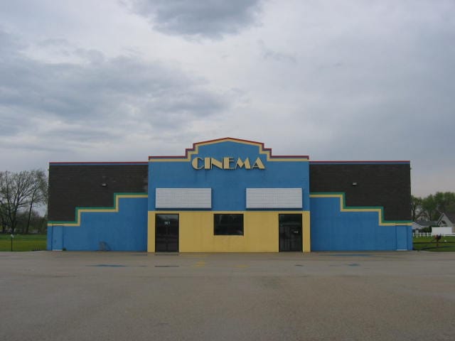

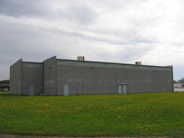
Property Detail
301 Dannys Dr
Ottawa, IL
J M FIALKOS RESUB, LT 8 SEC 23-31-3
33-23-222001
La Salle
Commercialnec
Illinois
B and X Area of moderate flood hazard, usually the area between the limits of the 100-year and 500-year floods.
8
2024
1.62 AC
2025
I-39 Corr/LaSalle County
963900
Chicago
12,060 SF
NEARBY LISTINGS FOR SALE OR LEASE
DEMOGRAPHICS near 301 Dannys Dr
1 mile
3 mile
5 mile
2025 Total Population
3,755
16,637
18,329
2030 Population
3,748
16,711
18,387
Pop Growth 2025-2030
(0.19%)
+ 0.44%
+ 0.32%
Average Age
44
42
42
2025 Total Households
1,666
7,063
7,820
HH Growth 2025-2030
(0.30%)
+ 0.31%
+ 0.19%
Median Household Inc
$53,938
$56,584
$57,121
Avg Household Size
2.20
2.30
2.30
2025 Avg HH Vehicles
2.00
2.00
2.00
Median Home Value
$131,129
$105,197
$106,045
Median Year Built
1966
1956
1956
Nearby Places
Map Layers
Map Styles
 Street
 Aerial
Layers
 Traffic
 Biking
Places
Listings with unknown addresses are not visible on the map
- Restaurants
- Banks
- Shops
- Fitness
- Groceries
Nearby Properties
Address
Land Use
TOTAL SIZE
Lot Size
Zoning
Address
Land Use
TOTAL SIZE
Lot Size
Zoning
119,815 SF
12.22 AC
Address
Land Use
TOTAL SIZE
Lot Size
Zoning
24,406 SF
12.15 AC
Address
Land Use
TOTAL SIZE
Lot Size
Zoning
102,400 SF
6.96 AC
Address
Land Use
TOTAL SIZE
Lot Size
Zoning
135,660 SF
35.14 AC
Address
Land Use
TOTAL SIZE
Lot Size
Zoning
81,848 SF
1.80 AC
Address
Land Use
TOTAL SIZE
Lot Size
Zoning
49,896 SF
4.20 AC
Address
Land Use
TOTAL SIZE
Lot Size
Zoning
65,220 SF
13.14 AC
Address
Land Use
TOTAL SIZE
Lot Size
Zoning
11.80 AC
Address
Land Use
TOTAL SIZE
Lot Size
Zoning
39,428 SF
2.97 AC
Address
Land Use
TOTAL SIZE
Lot Size
Zoning
35,660 SF
2.50 AC
Address
Land Use
TOTAL SIZE
Lot Size
Zoning
63,648 SF
2.24 AC
Address
Land Use
TOTAL SIZE
Lot Size
Zoning
3,500 SF
1.17 AC
Address
Land Use
TOTAL SIZE
Lot Size
Zoning
1,070,495 SF
41.04 AC
Address
Land Use
TOTAL SIZE
Lot Size
Zoning
154,004 SF
3.73 AC
Address
Land Use
TOTAL SIZE
Lot Size
Zoning
231,526 SF
17.63 AC
Address
Land Use
TOTAL SIZE
Lot Size
Zoning
14,780 SF
2.04 AC
Address
Land Use
TOTAL SIZE
Lot Size
Zoning
2,510 SF
19.08 AC
Address
Land Use
TOTAL SIZE
Lot Size
Zoning
124,714 SF
3.21 AC
Address
Land Use
TOTAL SIZE
Lot Size
Zoning
10,488 SF
2 AC
Address
Land Use
TOTAL SIZE
Lot Size
Zoning
160 SF
6.15 AC
Address
Land Use
TOTAL SIZE
Lot Size
Zoning
1,836 SF
395.68 AC
Address
Land Use
TOTAL SIZE
Lot Size
Zoning
213,958 SF
5 AC
Address
Land Use
TOTAL SIZE
Lot Size
Zoning
10,950 SF
1.40 AC
Address
Land Use
TOTAL SIZE
Lot Size
Zoning
11,748 SF
1.43 AC
Address
Land Use
TOTAL SIZE
Lot Size
Zoning
2,944 SF
0.60 AC
Address
Land Use
TOTAL SIZE
Lot Size
Zoning
13,000 SF
1.51 AC
Address
Land Use
TOTAL SIZE
Lot Size
Zoning
6,224 SF
1.75 AC
Address
Land Use
TOTAL SIZE
Lot Size
Zoning
11,089 SF
0.94 AC
Address
Land Use
TOTAL SIZE
Lot Size
Zoning
41,421 SF
4.01 AC
Address
Land Use
TOTAL SIZE
Lot Size
Zoning
73,792 SF
4.02 AC
The World's #1 Commercial Real Estate Marketplace
Connect with us
© 2026 CoStar Group
The information above has been obtained from sources believed reliable. While we do not doubt its accuracy we have not verified it and make no guarantee, warranty or representation about it. It is your responsibility to independently confirm its accuracy and completeness. Any projections, opinions, assumptions, or estimates used are for example only and do not represent the current or future performance of the property. The value of this transaction to you depends on tax and other factors which should be evaluated by your tax, financial, and legal advisors. You and your advisors should conduct a careful, independent investigation of the property to determine to your satisfaction the suitability of the property for your needs.