Property Record
301 E 12Th St, Mendota, IL 61342

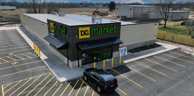
Property Detail
301 E 12Th St
Ottawa, IL
PHALEN'S INDUSTRIAL PARK SUB, LTS 4 & 5 SEC 34-36-1
01-34-107009
LA SALLE
Commercialnec
Illinois
2024
4-5
2025
2.36 AC
962000
I-39 Corr/LaSalle County
12,784 SF
Chicago
NEARBY LISTINGS FOR SALE OR LEASE
DEMOGRAPHICS near 301 E 12Th St
1 mile
3 mile
5 mile
2025 Total Population
3,298
7,313
7,927
2030 Population
3,257
7,210
7,812
Pop Growth 2025-2030
(1.24%)
(1.41%)
(1.45%)
Average Age
40
41
41
2025 Total Households
1,245
2,895
3,154
HH Growth 2025-2030
(1.37%)
(1.49%)
(1.55%)
Median Household Inc
$67,445
$64,282
$65,930
Avg Household Size
2.50
2.40
2.40
2025 Avg HH Vehicles
2.00
2.00
2.00
Median Home Value
$142,742
$145,524
$147,874
Median Year Built
1956
1958
1958
Nearby Places
Map Layers
Map Styles
 Street
 Aerial
Layers
 Traffic
 Biking
Places
Listings with unknown addresses are not visible on the map
- Restaurants
- Banks
- Shops
- Fitness
- Groceries
PUBLIC TRANSPORTATION
COMMUTER RAIL
Mendota Amtrak Station (Carl Sandburg - Amtrak, Illinois Zephyr - Amtrak, Southwest Chief - Amtrak)
Drive
Walk
Distance
Mendota Amtrak Station (Carl Sandburg - Amtrak, Illinois Zephyr - Amtrak, Southwest Chief - Amtrak)
1 min
10 min
0.6 mi
Freight Ports
Port Milwaukee
Drive
Walk
Distance
Port Milwaukee
164 min
143.9 mi
SALE & LEASE HISTORY
LISTING DATE
SALE/LEASE

Apr 18, 2023
For Sale
Nearby Properties
Address
Land Use
TOTAL SIZE
Lot Size
Zoning
Address
Land Use
TOTAL SIZE
Lot Size
Zoning
1,155 SF
30 AC
Address
Land Use
TOTAL SIZE
Lot Size
Zoning
37.10 AC
Address
Land Use
TOTAL SIZE
Lot Size
Zoning
245,030 SF
14.36 AC
Address
Land Use
TOTAL SIZE
Lot Size
Zoning
202,418 SF
15.50 AC
Address
Land Use
TOTAL SIZE
Lot Size
Zoning
27,741 SF
5.98 AC
Address
Land Use
TOTAL SIZE
Lot Size
Zoning
62,128 SF
27.06 AC
Address
Land Use
TOTAL SIZE
Lot Size
Zoning
149,296 SF
19.53 AC
Address
Land Use
TOTAL SIZE
Lot Size
Zoning
90,000 SF
19.30 AC
Address
Land Use
TOTAL SIZE
Lot Size
Zoning
9,000 SF
12.82 AC
Address
Land Use
TOTAL SIZE
Lot Size
Zoning
6,512 SF
11.25 AC
Address
Land Use
TOTAL SIZE
Lot Size
Zoning
92,574 SF
14.32 AC
Address
Land Use
TOTAL SIZE
Lot Size
Zoning
1.70 AC
Address
Land Use
TOTAL SIZE
Lot Size
Zoning
12,073 SF
5.07 AC
Address
Land Use
TOTAL SIZE
Lot Size
Zoning
60,473 SF
16.58 AC
Address
Land Use
TOTAL SIZE
Lot Size
Zoning
50,650 SF
8.44 AC
Address
Land Use
TOTAL SIZE
Lot Size
Zoning
25,637 SF
9.09 AC
Address
Land Use
TOTAL SIZE
Lot Size
Zoning
35,100 SF
1.79 AC
Address
Land Use
TOTAL SIZE
Lot Size
Zoning
2.03 AC
Address
Land Use
TOTAL SIZE
Lot Size
Zoning
1.75 AC
Address
Land Use
TOTAL SIZE
Lot Size
Zoning
0.58 AC
Address
Land Use
TOTAL SIZE
Lot Size
Zoning
0.38 AC
Address
Land Use
TOTAL SIZE
Lot Size
Zoning
3,432 SF
3.32 AC
Address
Land Use
TOTAL SIZE
Lot Size
Zoning
36,500 SF
15.03 AC
Address
Land Use
TOTAL SIZE
Lot Size
Zoning
11,628 SF
0.32 AC
Address
Land Use
TOTAL SIZE
Lot Size
Zoning
24,894 SF
8.34 AC
Address
Land Use
TOTAL SIZE
Lot Size
Zoning
13,575 SF
1.68 AC
Address
Land Use
TOTAL SIZE
Lot Size
Zoning
16,872 SF
2.92 AC
Address
Land Use
TOTAL SIZE
Lot Size
Zoning
4,200 SF
1.26 AC
Address
Land Use
TOTAL SIZE
Lot Size
Zoning
32,000 SF
1.83 AC
The World's #1 Commercial Real Estate Marketplace
Connect with us
© 2026 CoStar Group
The information above has been obtained from sources believed reliable. While we do not doubt its accuracy we have not verified it and make no guarantee, warranty or representation about it. It is your responsibility to independently confirm its accuracy and completeness. Any projections, opinions, assumptions, or estimates used are for example only and do not represent the current or future performance of the property. The value of this transaction to you depends on tax and other factors which should be evaluated by your tax, financial, and legal advisors. You and your advisors should conduct a careful, independent investigation of the property to determine to your satisfaction the suitability of the property for your needs.