Property Record
301 E 4Th St, Junction City, KS 66441
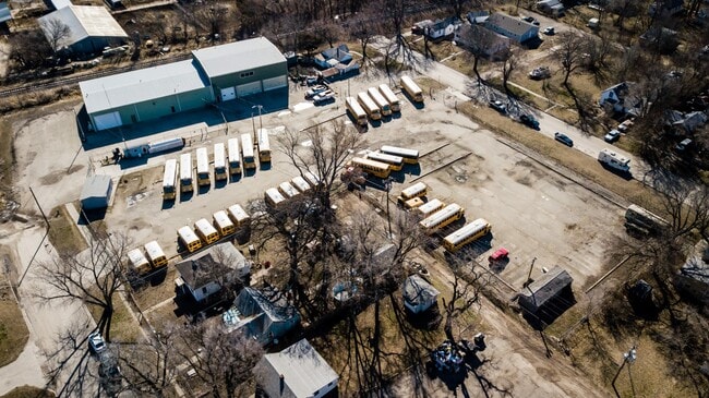

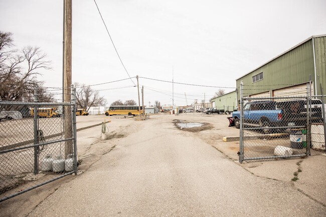
Property Detail
301 E 4Th St
111-12-0-10-08-005.00-0
ADD C, TRACT 3 LESS S 120 SECTION 12 TOWNSHIP 12 RANGE 05
Officebuilding
Geary
IL
Kansas
C and X Area of minimal flood hazard, usually depicted on FIRMs as above the 500-year flood level.
0.60 AC
2024
I-70 Corridor
2025
Other Market Areas
000500
Manhattan, KS
10,320 SF
NEARBY LISTINGS FOR SALE OR LEASE
-
-
View all Junction City listings for sale on LoopNet.com
DEMOGRAPHICS near 301 E 4Th St
1 mile
3 mile
5 mile
2025 Total Population
6,008
24,774
36,786
2030 Population
6,015
24,478
36,170
Pop Growth 2025-2030
+ 0.12%
(1.19%)
(1.67%)
Average Age
36
34
31
2025 Total Households
2,497
9,815
12,592
HH Growth 2025-2030
(0.28%)
(1.34%)
(1.84%)
Median Household Inc
$56,661
$55,420
$55,968
Avg Household Size
2.20
2.40
2.60
2025 Avg HH Vehicles
2.00
2.00
2.00
Median Home Value
$142,347
$157,249
$164,248
Median Year Built
1958
1982
1988
Nearby Places
Map Layers
Map Styles
 Street
 Aerial
Layers
 Traffic
 Biking
Places
Listings with unknown addresses are not visible on the map
- Restaurants
- Banks
- Shops
- Fitness
- Groceries
PUBLIC TRANSPORTATION
AIRPORT
Manhattan Regional
Drive
Walk
Distance
Manhattan Regional
22 min
13.8 mi
SALE & LEASE HISTORY
LISTING DATE
SALE/LEASE

Mar 30, 2023
For Sale
Nearby Properties
Address
Land Use
TOTAL SIZE
Lot Size
Zoning
Address
Land Use
TOTAL SIZE
Lot Size
Zoning
67,133 SF
15.71 AC
RG
Address
Land Use
TOTAL SIZE
Lot Size
Zoning
177,550 SF
68.20 AC
A
Address
Land Use
TOTAL SIZE
Lot Size
Zoning
228,233 SF
19.18 AC
Address
Land Use
TOTAL SIZE
Lot Size
Zoning
126,667 SF
3.17 AC
RM
Address
Land Use
TOTAL SIZE
Lot Size
Zoning
28,589 SF
85 AC
IL
Address
Land Use
TOTAL SIZE
Lot Size
Zoning
78,174 SF
35.10 AC
RM
Address
Land Use
TOTAL SIZE
Lot Size
Zoning
18,321 SF
0.67 AC
Address
Land Use
TOTAL SIZE
Lot Size
Zoning
16,850 SF
0.59 AC
CCS
Address
Land Use
TOTAL SIZE
Lot Size
Zoning
11,679 SF
49.73 AC
Address
Land Use
TOTAL SIZE
Lot Size
Zoning
62,043 SF
3.17 AC
CS
Address
Land Use
TOTAL SIZE
Lot Size
Zoning
34,700 SF
1.51 AC
RM
Address
Land Use
TOTAL SIZE
Lot Size
Zoning
17,388 SF
0.44 AC
Address
Land Use
TOTAL SIZE
Lot Size
Zoning
16,320 SF
6.78 AC
Address
Land Use
TOTAL SIZE
Lot Size
Zoning
8,828 SF
6.30 AC
RS
Address
Land Use
TOTAL SIZE
Lot Size
Zoning
56,611 SF
9.20 AC
CR
Address
Land Use
TOTAL SIZE
Lot Size
Zoning
56,546 SF
7.39 AC
RG
Address
Land Use
TOTAL SIZE
Lot Size
Zoning
20,898 SF
5.87 AC
CR
Address
Land Use
TOTAL SIZE
Lot Size
Zoning
29,248 SF
6.20 AC
RS
Address
Land Use
TOTAL SIZE
Lot Size
Zoning
15,452 SF
0.42 AC
Address
Land Use
TOTAL SIZE
Lot Size
Zoning
184,351 SF
29.28 AC
IL
Address
Land Use
TOTAL SIZE
Lot Size
Zoning
58,662 SF
3.34 AC
Address
Land Use
TOTAL SIZE
Lot Size
Zoning
16,235 SF
5.90 AC
Address
Land Use
TOTAL SIZE
Lot Size
Zoning
36,456 SF
2.72 AC
CS
Address
Land Use
TOTAL SIZE
Lot Size
Zoning
93,469 SF
12.98 AC
Address
Land Use
TOTAL SIZE
Lot Size
Zoning
35,825 SF
6.14 AC
RS
Address
Land Use
TOTAL SIZE
Lot Size
Zoning
43,404 SF
2.80 AC
Address
Land Use
TOTAL SIZE
Lot Size
Zoning
35,160 SF
2.30 AC
RS
Address
Land Use
TOTAL SIZE
Lot Size
Zoning
13,920 SF
1.47 AC
CCS
Address
Land Use
TOTAL SIZE
Lot Size
Zoning
41,330 SF
3.22 AC
RD
Address
Land Use
TOTAL SIZE
Lot Size
Zoning
832 SF
189 AC
AP
The World's #1 Commercial Real Estate Marketplace
Connect with us
© 2026 CoStar Group
The information above has been obtained from sources believed reliable. While we do not doubt its accuracy we have not verified it and make no guarantee, warranty or representation about it. It is your responsibility to independently confirm its accuracy and completeness. Any projections, opinions, assumptions, or estimates used are for example only and do not represent the current or future performance of the property. The value of this transaction to you depends on tax and other factors which should be evaluated by your tax, financial, and legal advisors. You and your advisors should conduct a careful, independent investigation of the property to determine to your satisfaction the suitability of the property for your needs.