Property Record
301 E Bay St, Savannah, GA 31401
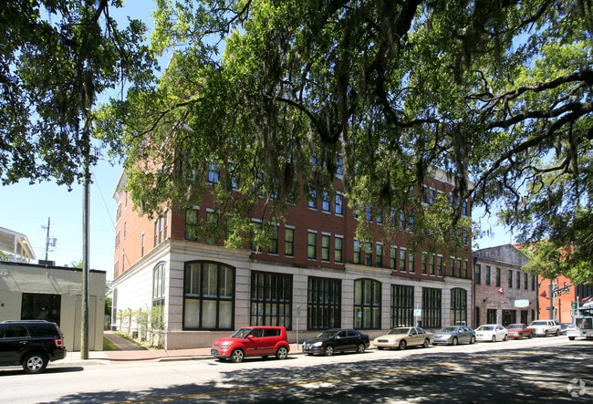

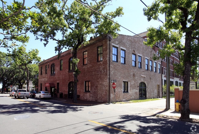

Property Detail
301 E Bay St
2000418009
PARECEL 1 WARREN WARD, 2ND GMD, SAVANNAH
Hotel
CHATHAM
RBC
Georgia
B and X Area of moderate flood hazard, usually the area between the limits of the 100-year and 500-year floods.
2-3
2024
0.38 AC
2025
Savannah Historic District
011700
Savannah
37,400 SF
Savannah, GA
NEARBY LISTINGS FOR SALE OR LEASE
DEMOGRAPHICS near 301 E Bay St
1 mile
3 mile
5 mile
2025 Total Population
13,172
69,473
116,891
2030 Population
14,153
73,469
123,034
Pop Growth 2025-2030
+ 7.45%
+ 5.75%
+ 5.26%
Average Age
35
38
38
2025 Total Households
5,635
29,368
47,219
HH Growth 2025-2030
+ 8.91%
+ 6.22%
+ 5.65%
Median Household Inc
$61,511
$50,803
$51,742
Avg Household Size
1.80
2.20
2.20
2025 Avg HH Vehicles
1.00
1.00
1.00
Median Home Value
$814,213
$304,540
$287,834
Median Year Built
1950
1953
1961
Nearby Places
Map Layers
Map Styles
 Street
 Aerial
Layers
 Traffic
 Biking
Places
Listings with unknown addresses are not visible on the map
- Restaurants
- Banks
- Shops
- Fitness
- Groceries
PUBLIC TRANSPORTATION
COMMUTER RAIL
Savannah (Palmetto - Amtrak, Silver Meteor - Amtrak, Silver Star - Amtrak)
Drive
Walk
Distance
Savannah (Palmetto - Amtrak, Silver Meteor - Amtrak, Silver Star - Amtrak)
9 min
4.4 mi
AIRPORT
Savannah/Hilton Head International
Drive
Walk
Distance
Savannah/Hilton Head International
19 min
9.9 mi
Hilton Head
Drive
Walk
Distance
Hilton Head
59 min
37.5 mi
Freight Ports
Georgia Ports - Savannah
Drive
Walk
Distance
Georgia Ports - Savannah
11 min
5.8 mi
Nearby Properties
Address
Land Use
TOTAL SIZE
Lot Size
Zoning
Address
Land Use
TOTAL SIZE
Lot Size
Zoning
1,400 SF
6.97 AC
D-X
Address
Land Use
TOTAL SIZE
Lot Size
Zoning
7,500 SF
382.12 AC
I-H
Address
Land Use
TOTAL SIZE
Lot Size
Zoning
22.34 AC
PUDBW
Address
Land Use
TOTAL SIZE
Lot Size
Zoning
453,984 SF
10.42 AC
Address
Land Use
TOTAL SIZE
Lot Size
Zoning
31,396 SF
1.69 AC
BG
Address
Land Use
TOTAL SIZE
Lot Size
Zoning
86,336 SF
1.08 AC
BB
Address
Land Use
TOTAL SIZE
Lot Size
Zoning
354,322 SF
6.30 AC
IH
Address
Land Use
TOTAL SIZE
Lot Size
Zoning
4,930 SF
1.18 AC
I-L
Address
Land Use
TOTAL SIZE
Lot Size
Zoning
421 SF
6.82 AC
PUDBW
Address
Land Use
TOTAL SIZE
Lot Size
Zoning
351,297 SF
2.08 AC
BC1
Address
Land Use
TOTAL SIZE
Lot Size
Zoning
124,080 SF
1.66 AC
BB
Address
Land Use
TOTAL SIZE
Lot Size
Zoning
173,554 SF
0.72 AC
BB
Address
Land Use
TOTAL SIZE
Lot Size
Zoning
108,273 SF
18.20 AC
PUDBC
Address
Land Use
TOTAL SIZE
Lot Size
Zoning
33,000 SF
1.92 AC
I-L
Address
Land Use
TOTAL SIZE
Lot Size
Zoning
199,424 SF
2.49 AC
BN
Address
Land Use
TOTAL SIZE
Lot Size
Zoning
116,928 SF
1.10 AC
BB
Address
Land Use
TOTAL SIZE
Lot Size
Zoning
84,560 SF
0.31 AC
BC1
Address
Land Use
TOTAL SIZE
Lot Size
Zoning
77,610 SF
0.33 AC
BC1
Address
Land Use
TOTAL SIZE
Lot Size
Zoning
245,610 SF
1.10 AC
RIPC
Address
Land Use
TOTAL SIZE
Lot Size
Zoning
92,132 SF
4.92 AC
PUDBW
Address
Land Use
TOTAL SIZE
Lot Size
Zoning
115,069 SF
1.14 AC
BC1
Address
Land Use
TOTAL SIZE
Lot Size
Zoning
9,303 SF
9.84 AC
PUDM
Address
Land Use
TOTAL SIZE
Lot Size
Zoning
120,084 SF
0.48 AC
BC1
Address
Land Use
TOTAL SIZE
Lot Size
Zoning
3.15 AC
Address
Land Use
TOTAL SIZE
Lot Size
Zoning
116,000 SF
0.53 AC
BB
Address
Land Use
TOTAL SIZE
Lot Size
Zoning
400,000 SF
1.12 AC
I-L
Address
Land Use
TOTAL SIZE
Lot Size
Zoning
0.49 AC
BC1
Address
Land Use
TOTAL SIZE
Lot Size
Zoning
9 AC
RMF-2-35
Address
Land Use
TOTAL SIZE
Lot Size
Zoning
7,900 SF
1.98 AC
RIPB1
Address
Land Use
TOTAL SIZE
Lot Size
Zoning
60,911 SF
0.17 AC
BB
The World's #1 Commercial Real Estate Marketplace
Connect with us
© 2026 CoStar Group
The information above has been obtained from sources believed reliable. While we do not doubt its accuracy we have not verified it and make no guarantee, warranty or representation about it. It is your responsibility to independently confirm its accuracy and completeness. Any projections, opinions, assumptions, or estimates used are for example only and do not represent the current or future performance of the property. The value of this transaction to you depends on tax and other factors which should be evaluated by your tax, financial, and legal advisors. You and your advisors should conduct a careful, independent investigation of the property to determine to your satisfaction the suitability of the property for your needs.